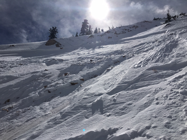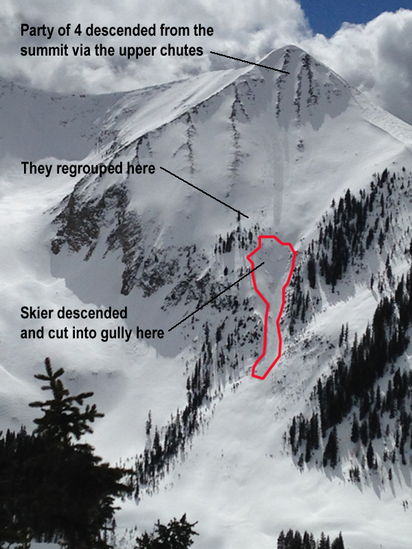
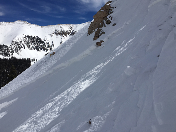
Around 2:00 p.m. a group of four skiers descended the the NE face of Tukno, a 1700 foot run with steep chutes at the top, a lower angle bowl in the middle, and a very steep convex roll into a gully near the bottom. Conscious of wind slabs that had formed three days prior, the group dug in the snow and performed a ski cut at the top of the chutes which produced a loose, long running sluff.
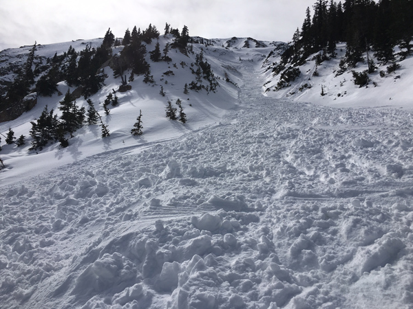
The party skied the upper chutes and bowl, and then regrouped on top of the steep, complicated convexity that fell into the gully. The first member of the party worked down the the steep NE flank of the gully before dropping in through some rocks. He made a couple turns before the slab fractured and he was swept over rocks and carried 200' through the gully. The debris fanned out and stopped on a lower angle apron.
About 2:30 p.m. I received a text from the injured skier who said he had been swept over a cliff, had a broken patella, and needed to be evacuated. He was a local skier who had sent in observations over the winter. I had met him about a month prior and gotten his phone number.
I notified GCSAR and we assembled a hasty team of 4 members including myself. We mobilized to the Geyser Pass trailhead, and the hasty team snowmobiled to the end of the road in Gold Basin and then began skinning in. Within a quarter mile we encountered the party coming out in what turns out to be an amazing self rescue with the assistance of another group.
The Moab Winter Search and Rescue team maintains a sled just above treeline on Laurel Ridge which is across the basin from where the accident occurred. In a stroke of luck, a party from Winter Park, CO saw the avalanche occur and they happened to be standing right next to the sled. A snowboarder in the party grabbed the sled, descended a 1400' run known as the Funnel, and then he and his group dragged it up to the accident site.
Meanwhile, the accident party had performed first aid and fashioned a sled from skis to get the victim down to lower angle terrain. The group then hauled the victim out in the sled until we encountered them. We hauled the sled about a quarter mile to the end of the Gold Basin Road, where GCSAR had staged a UHV with tracks to haul the victim the rest of the way out to the parking lot at the trailhead. The patient was transferred to a 4wd ambulance and ultimately transported to a hospital in Grand Junction.
The NE face of Tukno is a 1700' run with steep chutes at the top, a lower angle bowl of around 30 degrees in the middle, followed by a steep gully that terminates on a low angle apron. Complicated convexities surround the entrance into the gully and the area is rocky and steep with slope angles varying between 40 and 45 degrees where the slide was initiated.
On the day of the accident, skies were clear and temperatures were in the mid 30's at 10,000'. Winds were light from the NE. 6-8" of medium density snow, accompanied by moderate SW winds had fallen two days prior.
By the end of January, the La Sals had seen an exceptional winter with regular storms and a snowpack at around 175% of normal. Average base depth was 70" and the snowpack was generally very strong. A significant storm over Christmas produced a wide spread avalanche cycle. The NE face of Tukno fractured 6' deep to the ground and ran full track. January storms continued to pile on snow and on February 1, a 16" storm again caused an avalanche on the NE face of Tukno.
February saw dry and unseasonably warm temperatures, as well as a fair amount of wind that scoured much of the highest exposed terrain. Other than the storm on Feb 1, the rest of the month was dry but for 6" that fell on Feb 22. Spring conditions were in full effect with stout melt freeze crusts and corn snow on SE-S-W aspects. The snowpack was mostly stable and people were getting everywhere; climbing peaks, skiing and high marking on steep, upper elevation northerly facing terrain without incident.
High pressure and unseasonably warm temperatures continued to dominate the region until a storm on March 6-7 produced 6-8" of medium density snow accompanied by moderate southwest winds. Natural loose snow sluffing occurred during the storm on northerly aspects over about 40 degrees. During field work on March 7, I observed wind slabs up to 18" deep along the lee sides of upper elevation ridge crests and terrain features. They weren't very reactive but I felt they were worth mentioning in the next day's advisory.
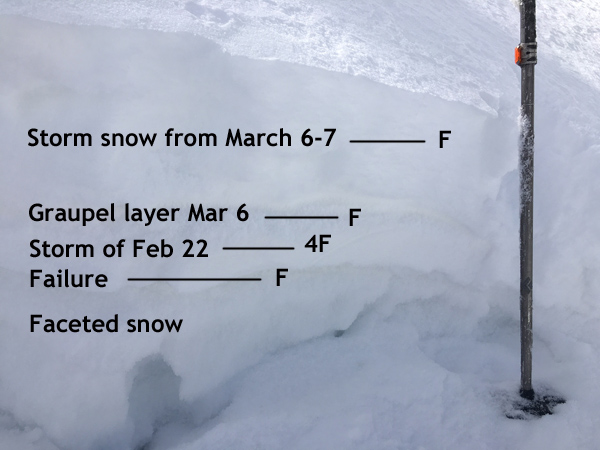
Storm snow on top was dense loose, fist hardness. The underlying slab from Feb 22 was also very soft, 4 finger hardness. Failure was on underlying facets near the ground.
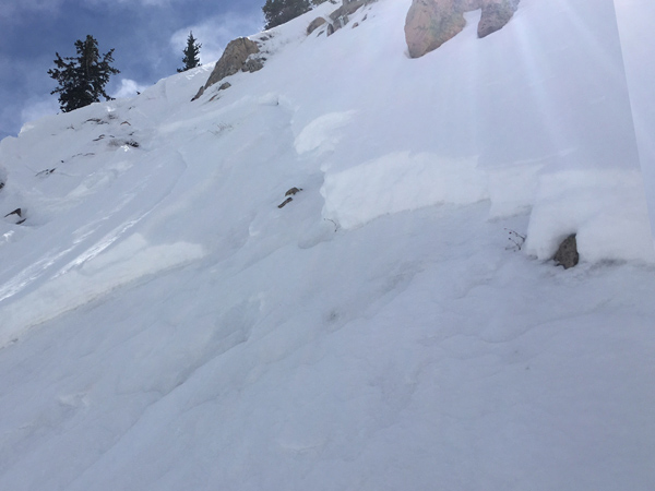
The snow in this steep and rocky area is very shallow due to the repeat running nature of the slide path this season. This isolated pocket seems to be very much the exception, rather than the rule for the overall snowpack. Rocks, complex terrain features, and the terrain trap nature of the gully all contributed to the severity of this accident.