| Please join us at the 23rd annual Black Diamond Fall Fundraiser Party Thursday Sept 15. Tickets are on sale now here, at the Black Diamond store & at REI. Special bonus raffle for online ticket purchasers! |
| Please join us at the 23rd annual Black Diamond Fall Fundraiser Party Thursday Sept 15. Tickets are on sale now here, at the Black Diamond store & at REI. Special bonus raffle for online ticket purchasers! |
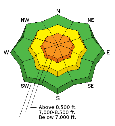
| Advisory: Ogden Area Mountains | Issued by Mark Staples for Thursday - February 4, 2016 - 5:51am |
|---|

|
bottom line Today the avalanche danger is CONSIDERABLE on any upper elevation slope with recently formed wind slabs or on any upper elevation slope facing NW through NE where a slide could break at the ground. Otherwise, a MODERATE danger exists on mid elevation slopes due to the possible presence of a few different weak faceted layers buried 1-2 feet deep.
|
 |
special announcement TONIGHT, Thursday at 6:00pm - The Utah Adventure Journal Speaker Series presents professional skier Brody Leven, who will share the story of his incredible adventure to climb and ski the northernmost active volcano in a 36-hour push from his sailboat base camp. More info HERE. Tuesday, February 9th - Companion Rescue at Weller Recreation from 6:30-9pm. For more info HERE. Wednesday February 10th - Avalanche Clinic for Ice Climbers. For more info click HERE. There are still a few spaces in the Women’s Backcountry 101 avalanche classes at Brighton this weekend and Snowbasin in 2 weeks. For more info on those classes and other education offerings through out the state, check out our Education Page. |
 |
current conditions Yesterday 1-2 inches of snow fell in the Ogden area. Winds increased since yesterday and this morning were blowing 10-15 mph gusting to 30 mph from the SW. Above 9000 feet winds were gusting up to 45 mph. Temperatures are in the single digits to low teens F. Cold temperatures, new snow, and limited sunshine have made great riding conditions on wind sheltered slopes. |
 |
recent activity We are saddened by the avalanche death of a backcountry skier who was killed Sunday, along the Park City ridge line. A preliminary report is HERE. We visited the site yesterday and will have more information posted in coming days. On Tuesday, avalanche reduction work with explosives released hard wind slabs in upper elevation terrain on a variety of aspects including southerly. Some slides were large enough to bury a person. Yesterday (Wednesday), another hard wind slab about 8 inches thick resting on faceted crystals was triggered during avalanche reduction work. |
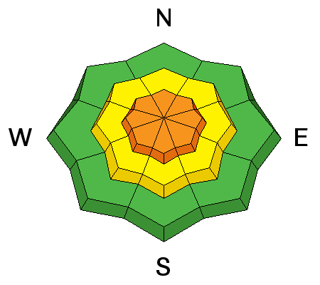
| type | aspect/elevation | characteristics |
|---|

|
|
LIKELIHOOD
 LIKELY
UNLIKELY
SIZE
 LARGE
SMALL
TREND
 INCREASING DANGER
SAME
DECREASING DANGER
|
|
description
Drew and his partner's put it best while skiing yesterday: "We waned from Moderate to Considerable avalanche danger on all upper elevation aspects. Our only concerns were wind slabs that still could be reactive from Feb 1st East wind event and maybe repeater slides in the Snowbasin periphery." Increased winds this morning make it hard for me to drop the danger rating. I'm unsure how much snow they are transporting and how many new wind slabs have been formed. Either way, wind slabs from either early this week or from this morning's winds are the primary concern. |
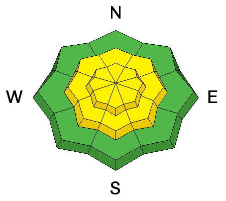
| type | aspect/elevation | characteristics |
|---|

|
|
LIKELIHOOD
 LIKELY
UNLIKELY
SIZE
LARGE
SMALL
TREND
INCREASING DANGER
SAME
DECREASING DANGER
|
|
description
There are a couple of potential weak layers within about the top 2 feet of the snowpack worth looking for and assessing. A layer of surface hoar was buried a last Thursday. Additionally, there was rain last Friday below 7000 feet and snow above 8000 feet. Somewhere in between this elevation band, a mix of rain and snow created a weak layer under the new snow. Drew and his partners yesterday didn't feel as though it had enough of a load on top of it to be an major avalanche concern. Fortunately these layers are not buried deeply. Looking for them and assessing them with stability tests is quick and easy to do. |
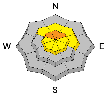
| type | aspect/elevation | characteristics |
|---|

|
|
LIKELIHOOD
LIKELY
UNLIKELY
SIZE
 LARGE
SMALL
TREND
INCREASING DANGER
SAME
DECREASING DANGER
|
|
description
As mentioned above, a few places may have lingering weak layers near the ground where avalanches previously occurred during the avalanche cycle just before Christmas. These places have a thinner than average snowpack. A good example and a place I would avoid is the backcountry area called Hell's Canyon area which is adjacent to Snowbasin. Other places near Salt Lake City with thin snowpacks where avalanches released in December have produced a few avalanches this week including the fatal one on Sunday. I have no idea what the odds are of triggering one of these slides, but I do know that the consequences would be severe. |
 |
weather It’s going to be another cold day with out much warming – ridge line temperatures will stay in the single digits and 8000’ temperatures warm to near 15. The northwesterly winds will increase today, especially along the higher ridge lines, where averages to 35 mph, with gusts to 50 mph are possible. Mid elevation winds speeds will average 15 mph by this afternoon. Clouds and winds will continue to increase tonight through Thursday, as a small disturbance brings a few inches of snow on Thursday. |
general announcements
|


