| Please join us at the 23rd annual Black Diamond Fall Fundraiser Party Thursday Sept 15. Tickets are on sale now here, at the Black Diamond store & at REI. Special bonus raffle for online ticket purchasers! |
| Please join us at the 23rd annual Black Diamond Fall Fundraiser Party Thursday Sept 15. Tickets are on sale now here, at the Black Diamond store & at REI. Special bonus raffle for online ticket purchasers! |
| Advisory: Ogden Area Mountains | Issued by Mark Staples for Friday - January 29, 2016 - 6:11am |
|---|

|
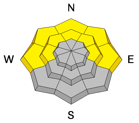
bottom line The avalanche danger will be rising today with an approaching storm bringing heavy snowfall and strong winds. We have issued an Avalanche Watch because we expect very dangerous avalanche conditions to develop within the next 24 hours. For this morning however, the danger is mostly MODERATE due to buried weak layers, shallow wind slabs, and potentially loose wet snow at low elevations. At the highest elevations on NW though N through E aspects, a CONSIDERABLE avalanche danger exists because many slopes in these places avalanched around the Solstice, have weak snow at the ground, and will likely slide again.
|
 |
avalanche watch THE FOREST SERVICE UTAH AVALANCHE CENTER IN SALT LAKE CITY HAS ISSUED A BACKCOUNTRY AVALANCHE WATCH. TIMING...IN EFFECT FROM 6 AM THIS MORNING UNTIL 6 AM SATURDAY. AFFECTED AREA...FOR THE MOUNTAINS OF NORTHERN AND CENTRAL UTAH AND SOUTHEASTERN IDAHO INCLUDING THE WASATCH RANGE...BEAR RIVER RANGE...WESTERN UINTA RANGE...AND MANTI SKYLINE PLATEAU. AVALANCHE DANGER...THE AVALANCHE DANGER IS EXPECTED TO RISE TO HIGH WITHIN THE NEXT 24 HOURS. IMPACTS...BY SATURDAY MORNING EXPECTED HEAVY SNOWFALL AND STRONG WINDS WILL CREATE WIDESPREAD AREAS OF UNSTABLE SNOW. BOTH HUMAN TRIGGERED AND NATURAL AVALANCHES WILL BE LIKELY. THIS WATCH DOES NOT APPLY TO SKI AREAS WHERE AVALANCHE HAZARD REDUCTION MEASURES ARE PERFORMED. |
 |
special announcement TONIGHT 5:30pm- Spots are still available for tonight's Companion Rescue course. Come learn from the pros how to quickly save your buried partners life. The course is designed for every backcountry user. Whether you're a novice or seasoned veteran, this is a great way to refine your rescue skills, learn more about your avalanche equipment and become more confident in your rescue abilities. For all details or to register click here: https://goo.gl/LJKGSQ Saturday 4:30pm - Brighton Resort hosts UAC Forecaster Craig Gordon for a special Know Before You Go awareness talk focused on the current backcountry conditions. Presentation will be held on 3rd floor of Alpine Rose Lodge and as always is free to attend. |
 |
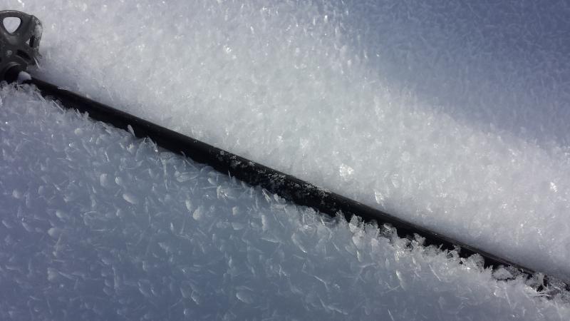
current conditions This morning the mountains near Ogden received 1-3 inches of snow. Temperatures at 7500 feet are at freezing while at 9500 feet they are near 20 degrees F. Westerly winds increased overnight and were blowing 15-20 mph gusting to 35 mph. Northerly aspects have great snow which is a mix of dense powder at lower elevations and some recycled powder at higher elevations. After the last two days of warm, sunny weather, most south aspects should have a solid ice crust this morning. Many areas on slopes shaded from the sun have weak snow at the surface. In some places it is surface hoar (frozen dew) and in other places it is faceted snow (aka - recycled powder). I don't think this will be long lasting problem and strong winds should destroy most of the surface hoar, but new snow this weekend may not bond well to the current snow surface. Photo below of surface hoar crystals near north Ogden Canyon.
|
 |
recent activity No avalanche activity was reported yesterday; however, there are a few avalanches from this week worth our attention. One is a slide triggered by a person heli skiing in Cardiff Fork near SLC. Drew added more information about this slide yesterday including a great summary of the weather and snowpack. Read more here. A third avalanche occurred on a South aspect on Gobbler's Knob probably on Jan 26/27 in between the fatal one (Jan 21) and a natural one (Jan 24, video). These avalanches on south aspects are notable because they tell us that south aspects contain weak facets unlike previous winters when we only need to worry about new snow avalanche problems on these aspects.
|
| type | aspect/elevation | characteristics |
|---|

|
|
LIKELIHOOD
 LIKELY
UNLIKELY
SIZE
 LARGE
SMALL
TREND
 INCREASING DANGER
SAME
DECREASING DANGER
|
|
description
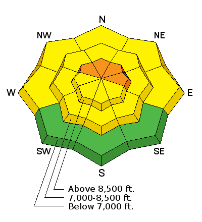
Faceted layers of snow that can produce a persistent slab avalanche exist mostly on NW through N through E facing slopes at upper elevations.The good news is that there has been minimal avalanche activity in the Ogden are mountains. The other good news is that weak facets under an ice crust on south aspects does not appear to be a problem in Ogden area compared to the SLC area. The most likely place to trigger an avalanche is on slopes that previously avalanched near the ground. We call these slopes "repeaters" because they either have or will produce more avalanches this season. Mid elevation slopes in the Ogden area mountains and slopes at other elevations that haven't avalanched are developing a deep, stronger snowpack. |
| type | aspect/elevation | characteristics |
|---|

|
|
LIKELIHOOD
LIKELY
UNLIKELY
SIZE
 LARGE
SMALL
TREND
INCREASING DANGER
SAME
DECREASING DANGER
|
|
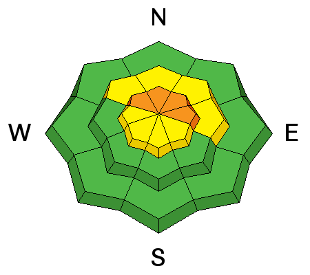
description
Increased winds this morning combined with a a few inches of snow and more coming will create some fresh wind slabs later today. They shouldn't be a problem this morning, but could be by late this afternoon. |
| type | aspect/elevation | characteristics |
|---|

|
|
LIKELIHOOD
LIKELY
UNLIKELY
SIZE
LARGE
SMALL
TREND
INCREASING DANGER
SAME
DECREASING DANGER
|
|
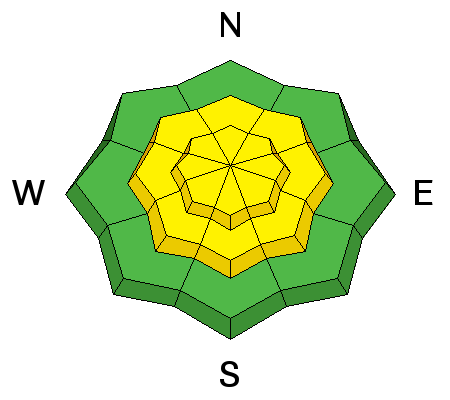
description
With some rain forecasted this afternoon and evening below 7500 feet, watch for loose, wet snow slides. These slides are possible at low elevations where rain falls on dry snow. |
 |
weather Snowfall will increase this afternoon as abundant moisture spreads into the area ahead of a cold front. Temperatures today will be in the 30's F and wont' be dropping much until tomorrow morning when the cold front crosses the area. Winds will remain westerly and blow 15-25 mph and gust to 35 mph with winds approaching 50 mph at 11,000 feet. Today 1-3 inches of dense snow should fall followed by another 3-6 inches tonight. Total water content of this snow should be about an inch by tomorrow morning. |
| general announcements Remember your information can save lives. If you see anything we should know about, please participate in the creation of our own community avalanche advisory by submitting snow and avalanche conditions. You can also call us at 801-524-5304, email by clicking HERE, or include #utavy in your tweet or Instagram. To get help in an emergency (to launch a rescue) in the Wasatch, call 911. Be prepared to give your GPS coordinates or the run name. Dispatchers have a copy of the Wasatch Backcountry Ski map. Backcountry Emergencies. It outlines your step-by-step method in the event of a winter backcountry incident. If you trigger an avalanche in the backcountry, but no one is hurt and you do not need assistance, please notify the nearest ski area dispatch to avoid a needless response by rescue teams. Thanks. Salt Lake and Park City – Alta Central (801-742-2033), Canyons Resort/PCMR Dispatch (435)615-1911 Snowbasin Resort Dispatch (801-620-1017), Powder Mountain Dispatch (801-745-3772 x 123). Sundance Dispatch (801-223-4150) EMAIL ADVISORY If you would like to get the daily advisory by email you will need to subscribe here. DAWN PATROL Hotline updated daily by 5-530am - 888-999-4019 option 8. Twitter Updates for your mobile phone - DETAILS UDOT canyon closures: LINK TO UDOT, or on Twitter, follow @UDOTavy, @CanyonAlerts or @AltaCentral Utah Avalanche Center mobile app - Get your advisory on your iPhone along with great navigation and rescue tools. Powderbird Helicopter Skiing - Blog/itinerary for the day Lost or Found something in the backcountry? - http://nolofo.com/ To those skinning uphill at resorts: it is your responsibility to know the resort policy on uphill travel. You can see the uphill travel policy for each resort here. IMPORTANT: Before skinning or hiking at a resort under new snow conditions, check in with Ski Patrol. Resorts can restrict or cut off access if incompatible with control and grooming operations. Benefit the Utah Avalanche Center when you shop from Backcountry.com or REI: Click this link for Backcountry.com or this link to REI, shop, and they will donate a percent of your purchase price to the UAC. Both offer free shipping (with some conditions) so this costs you nothing! Benefit the Utah Avalanche Center when you buy or sell on ebay - set the Utah Avalanche Center as a favorite non-profit in your ebay account here and click on ebay gives when you buy or sell. You can choose to have your seller fees donated to the UAC, which doesn't cost you a penny. This information does not apply to developed ski areas or highways where avalanche control is normally done. This advisory is from the U.S.D.A. Forest Service, which is solely responsible for its content. This advisory describes general avalanche conditions and local variations always exist. |