| Please join us at the 23rd annual Black Diamond Fall Fundraiser Party Thursday Sept 15. Tickets are on sale now here, at the Black Diamond store & at REI. Special bonus raffle for online ticket purchasers! |
| Please join us at the 23rd annual Black Diamond Fall Fundraiser Party Thursday Sept 15. Tickets are on sale now here, at the Black Diamond store & at REI. Special bonus raffle for online ticket purchasers! |
| Advisory: Ogden Area Mountains | Issued by Mark Staples for Sunday - January 10, 2016 - 7:19am |
|---|

|
bottom line Today the avalanche danger is MODERATE on all upper elevation slopes and on mid elevation slopes facing NW->N->E where avalanches in the new snow are possible.
|
 |
current conditions It’s another cold morning with temperatures in the upper teens F. Winds remain very calm and are only blowing 5-10 mph this morning from the WNW. The Ogden area received 1-2 inches of new snow since yesterday. With roughly a foot of new snow in most areas from the middle of last week, skiing and riding conditions are fantastic. Winds have been surprisingly calm, even in areas that typically received a lot of strong wind. Yesterday’s sun warmed the snow on south aspects just enough that you should find a thin crust on these slopes this morning. |
 |
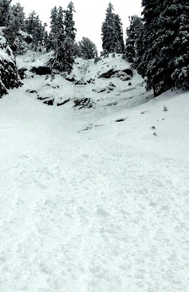
recent activity Most observers noted easy sluffing of the new snow especially on slopes with a crust under it or on slopes that slid around Christmas that have weak, faceted snow under the new snow. A rider was caught in a sluff yesterday in Argenta on a N aspect of Kessler Peak and carried over a rock band. See photo below and read about it here. Also, a skier triggered a soft slab avalanche on a NE facing slope at the head of Day’s Fork called Two Dogs. It produced a debris pile large enough to bury a person. Photo of a dry loose avalanche (aka a sluff or slough) that carried a rider over the rock band.
|
| type | aspect/elevation | characteristics |
|---|

|

|
LIKELIHOOD
 LIKELY
UNLIKELY
SIZE
 LARGE
SMALL
TREND
 INCREASING DANGER
SAME
DECREASING DANGER
|
|
description
Avalanche problems today will be confined to the new snow. Rather than list several different ones, I’ll lump them together under the storm slab avalanche problem.
The good news is that all of these issues should be predictable and easily observable while traveling in the mountains today. Photo of the snowpack on a a slope that avalanched on Dec 23. It had very thin snow during cold weather; consequently, the snowpack became weak and faceted. New snow from this week rest on these facets snow.
|
| type | aspect/elevation | characteristics |
|---|

|
|
LIKELIHOOD
 LIKELY
UNLIKELY
SIZE
 LARGE
SMALL
TREND
 INCREASING DANGER
SAME
DECREASING DANGER
|
|
description
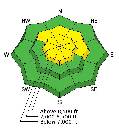
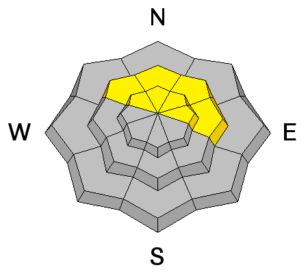
Where snowpack is about 5 ft (1.5m) deep, facets near the ground have gained strength and triggering a deep slab avalanche is unlikely. Triggering one remains possible in shallower areas where the snowpack is closer to 3 ft (1m) deep. How possible is it? That’s a good question and the answer is: we don’t know exactly. Avalanche professionals give themselves a wide margin of safety with this avalanche problem because of this uncertainty. What we do know is that this problem exists primarily on slopes facing NW through N through E at elevations above 8000 feet. Steep rocky slopes in these areas contain lots of potential trigger points around buried rocks. We also know that the snowpack received a load of new snow generally containing 1 inch of water. Not a huge load but enough that it’s worth being patient. Personally, I’d wait for a long period of high pressure without much wind before tackling my most ambitious objectives on these slopes. There's a long season ahead of us, don't be pressured by what others are doing. |
 |
weather This morning will have mostly cloudy skies and a few snow flurries. Skies should clear by this afternoon, and it should be a beautiful sunny day.
A ridge of high pressure will start building over the area this week and bring warmer temperatures, some inversions, and plenty of sunshine. Fortunately, this ridge will breakdown by Thursday and open the possibility for more snow. |
| general announcements Remember your information can save lives. If you see anything we should know about, please participate in the creation of our own community avalanche advisory by submitting snow and avalanche conditions. You can also call us at 801-524-5304, email by clicking HERE, or include #utavy in your tweet or Instagram. To get help in an emergency (to launch a rescue) in the Wasatch, call 911. Be prepared to give your GPS coordinates or the run name. Dispatchers have a copy of the Wasatch Backcountry Ski map. Backcountry Emergencies. It outlines your step-by-step method in the event of a winter backcountry incident. If you trigger an avalanche in the backcountry, but no one is hurt and you do not need assistance, please notify the nearest ski area dispatch to avoid a needless response by rescue teams. Thanks. Salt Lake and Park City – Alta Central (801-742-2033), Canyons Resort/PCMR Dispatch (435)615-1911 Snowbasin Resort Dispatch (801-620-1017), Powder Mountain Dispatch (801-745-3772 x 123). Sundance Dispatch (801-223-4150) EMAIL ADVISORY If you would like to get the daily advisory by email you will need to subscribe here. DAWN PATROL Hotline updated daily by 5-530am - 888-999-4019 option 8. Twitter Updates for your mobile phone - DETAILS UDOT canyon closures: LINK TO UDOT, or on Twitter, follow @UDOTavy, @CanyonAlerts or @AltaCentral Utah Avalanche Center mobile app - Get your advisory on your iPhone along with great navigation and rescue tools. Powderbird Helicopter Skiing - Blog/itinerary for the day Lost or Found something in the backcountry? - http://nolofo.com/ To those skinning uphill at resorts: it is your responsibility to know the resort policy on uphill travel. You can see the uphill travel policy for each resort here. IMPORTANT: Before skinning or hiking at a resort under new snow conditions, check in with Ski Patrol. Resorts can restrict or cut off access if incompatible with control and grooming operations. Benefit the Utah Avalanche Center wh |