| Please join us at the 23rd annual Black Diamond Fall Fundraiser Party Thursday Sept 15. Tickets are on sale now here, at the Black Diamond store & at REI. Special bonus raffle for online ticket purchasers! |
| Please join us at the 23rd annual Black Diamond Fall Fundraiser Party Thursday Sept 15. Tickets are on sale now here, at the Black Diamond store & at REI. Special bonus raffle for online ticket purchasers! |
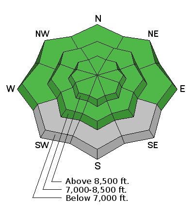
| Advisory: Ogden Area Mountains | Issued by Mark Staples for Wednesday - December 9, 2015 - 6:56am |
|---|

|
bottom line Avalanche conditions are generally safe but you could trigger small wind slabs in isolated locations.
|
 |
special announcement Today, those of you with an interest in snow science might want to attend a seminar that will be given at the U by Jordy Hendrikx titled “Snow Science: Taking a Multi-Faceted Approach to Understand Avalanches.” Consider attending an avalanche awareness class or beacon clinic. Classes this week are full, but there are several next week with space available that are worth attending. Go HERE for a list of classes. |
 |
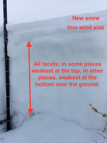
current conditions Both rain and snow fell Monday evening with rain falling to nearly 9000 feet. Near Salt Lake City and Provo 1-2 inches of snow fell with 0.1-0.2 inches of water. Near Ogden 3-4 inches of snow fell with about 0.5 inches of water. Since then winds have been blowing about 15 mph gusting in the 30's generally from the W with some SW winds. Temperatures have been warm. This morning temperatures range from the low to high 30's F. The main story is that the snowpack experienced some dramatic changes with recent rain and warm temperatures. The good news is that the snowpack is wet in many low elevation areas. It will refreeze and become strong when cold weather returns. The bad news is that the snowpack remains weak in many other places. We don't have a good map of the various snowpack conditions yet and will be watching very closely over the next few days as it continues to change. With several storms on the way between now and Monday, the state of the snowpack will have a strong effect on stability as we move into the weekend. Photo below from Evelyn from a NE aspect at 9800 feet in Big Cottonwood Canyon. "Seemed the snow near the ground was warming and becoming moist in places. While another 24 hours of warm temperatures is better than cold, it still won't be able to solve our weak facet problem."
Similar conditions were found by an observer above Park City on a N aspect at 9700 feet (video) |
 |
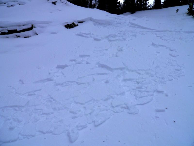
recent activity Skiers triggered some small wind slabs were triggered yesterday on North aspects around 10,000 feet at the head of Cardiff fork in Big Cottonwood Canyon. These wind slabs broke on facets near the ground. Additionally a skier near Snowbasin Ski Area on an East aspect at 8400 feet experienced some collapsing of the snowpack. These are clear signs of unstable snow, but generally isolated and mainly give us a warning of things to come once we add a load and a slab to the snowpack.
Photo: M. White |
| type | aspect/elevation | characteristics |
|---|

|
|
LIKELIHOOD
 LIKELY
UNLIKELY
SIZE
 LARGE
SMALL
TREND
 INCREASING DANGER
SAME
DECREASING DANGER
|
|
description
The only avalanche problem today is isolated, small wind slabs which should be easy to identify. Some may be stubborn while some may be easy to trigger. Overall avalanche conditions are generally safe because most slopes lack a slab. With snow coming tonight, Thursday night and Sunday expect the danger to rise. |
 |
weather Mountain temperatures should be warm again today with high temperatures near 40 degrees F. Winds will blow 15-20 mph gusting 30-40 mph from the W and SW. A weak disturbance will pass overhead tonight bringing about 2 inches of snow. A stronger but fast moving storm will come from the SW on Thursday evening and bring colder temperatures for Friday. Another storm should arrive Sunday from the NW. |
| general announcements Remember your information can save lives. If you see anything we should know about, please participate in the creation of our own community avalanche advisory by submitting snow and avalanche conditions. You can also call us at 801-524-5304, email by clicking HERE, or include #utavy in your tweet or Instagram. To get help in an emergency (to launch a rescue) in the Wasatch, call 911. Be prepared to give your GPS coordinates or the run name. Dispatchers have a copy of the Wasatch Backcountry Ski map. If you trigger an avalanche in the backcountry, but no one is hurt and you do not need assistance, please notify the nearest ski area dispatch to avoid a needless response by rescue teams. Thanks. Salt Lake and Park City – Alta Central (801-742-2033), Canyons Resort/PCMR Dispatch (435)615-1911 Snowbasin Resort Dispatch (801-620-1017), Powder Mountain Dispatch (801-745-3772 x 123). Sundance Dispatch (801-223-4150) EMAIL ADVISORY If you would like to get the daily advisory by email you will need to subscribe here. DAWN PATROL Hotline updated daily by 5-530am - 888-999-4019 option 8. Twitter Updates for your mobile phone - DETAILS UDOT canyon closures: LINK TO UDOT, or on Twitter, follow @UDOTavy, @CanyonAlerts or @AltaCentral Utah Avalanche Center mobile app - Get your advisory on your iPhone along with great navigation and rescue tools. Wasatch Powderbird Guides Blog/Itinerary for the Day. Lost or Found something in the backcountry? - http://nolofo.com/ To those skinning uphill at resorts: it is your responsibility to know the resort policy on uphill travel. You can see the uphill travel policy for each resort here. IMPORTANT: Before skinning or hiking at a resort under new snow conditions, check in with Ski Patrol. Resorts can restrict or cut off access if incompatible with control and grooming operations. Benefit the Utah Avalanche Center when you shop from Backcountry.com or REI: Click this link for Backcountry.com or this link to REI, shop, and they will donate a percent of your purchase price to the UAC. Both offer free shipping (with some conditions) so this costs you nothing! Benefit the Utah Avalanche Center when you buy or sell on ebay - set the Utah Avalanche Center as a favorite non-profit in your ebay account here and click on ebay gives when you buy or sell. You can choose to have your seller fees donated to the UAC, which doesn't cost you a penny. This information does not apply to developed ski areas or highways where avalanche control is normally done. This advisory is from the U.S.D.A. Forest Service, which is solely responsible for its content. This advisory describes general avalanche conditions and local variations always exist. |