| During the month of April, Mark Miller will donate $75 to the charity of your choice (5 to chose from, including the Utah Avalanche Center!) Mark Miller Subaru has raised over $300k in the previous 6 Do Good Feel Good events. More Info here |  |
| During the month of April, Mark Miller will donate $75 to the charity of your choice (5 to chose from, including the Utah Avalanche Center!) Mark Miller Subaru has raised over $300k in the previous 6 Do Good Feel Good events. More Info here | |
| Advisory: Ogden Area Mountains | Issued by Evelyn Lees for Wednesday - March 25, 2015 - 7:18am |
|---|

|
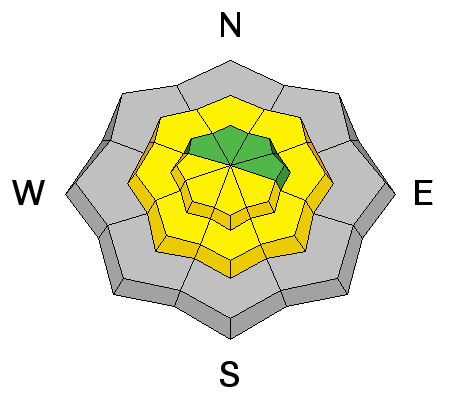
bottom line The avalanche danger is MODERATE for triggering wind slabs and cornices on steep, mid and upper elevation, wind drifted slopes, with Pockets of CONSIDERABLE danger in the highest elevation wind zones. The danger of wet, loose sluffs will increase to MODERATE as the day becomes warm and sunny and the winds decrease.
|
 |
special announcement Drew will update this forecast by 7:30 am tomorrow morning.
On Thursday, March 26, Annelise Loevlie will be the final speaker in the Utah Adventure Journal Speaker Series, sharing tales of adventures in far away lands balanced with the pressures of running a company and building a brand with meaning, all held together with a bilingual thread of passion - skiing. 6pm in the Wildflower Lounge, raffle to benefit the Utah Avalanche Center, 21+
Want to make a difference? On Thursday, March 26, join thousands of other Utahans in celebrating Love Utah Give Utah, supporting the non-profit organizations that form the framework of the quality of life in Utah. The Utah Avalanche Center has $1,700 in challenge pledges, just waiting to be matched. When you make an online donation on Thursday, or schedule a donation now for Thursday, your donation will instantly double and make the UAC eligible for other award donations, providing funding to produce advisories like this one. Last year Love UT Give UT raised over $1,000,000 in just 24 hours. For 2015, we hope to raise $2 million for 500 charities and schools across Utah. |
 |
current conditions The cold front finally sauntered through yesterday afternoon, leaving behind another couple inches of snow. Two-day totals are now in the 6 to 9” range in the Ogden area mountains, with about an inch of water. Skies have cleared above the Ogden mountains, and temperatures colder than they’ve been in a long time – in the low to mid teens and twenties. The spoiler were the northwesterly winds – at their peak speeds overnight, they were averaging to 35 to 40 mph, with gusts to 50 across the highest peaks. |
 |
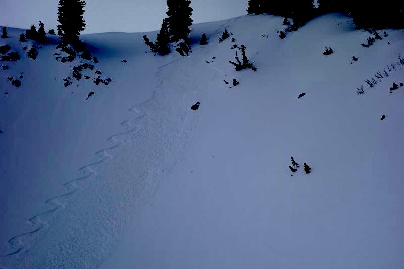
recent activity Yesterday, there were two reports of intentionally triggered soft wind drifts in the Salt Lake mountains, on Tuscarora and a chute in Wolverine, both about 8 inches deep and up to 50’ wide. Resort control work was also able to release wind slabs. Tuscarora Intentionally triggered wind slab Photo: Chester
|
| type | aspect/elevation | characteristics |
|---|

|
|
LIKELIHOOD
 LIKELY
UNLIKELY
SIZE
 LARGE
SMALL
TREND
 INCREASING DANGER
SAME
DECREASING DANGER
|
|
description
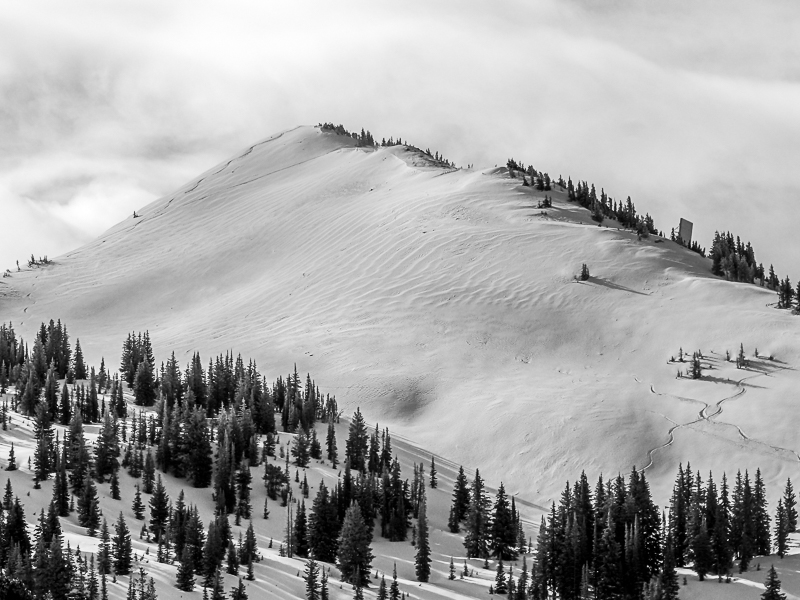
Today, sensitive wind drifts will be widespread, and found both along the high ridgelines and well down into the mid elevations. Sub ridges, gully walls, and mid slope break overs are classic places for wind slabs to form in addition to along ridge crests. A few of these wind drifts may be triggered remotely, if sitting on yesterday’s surface hoar. They all have the potential to run good distances due to the slick crusts beneath. These wind drifts will be most widespread on slopes facing northeast, east and southeast. Any cornices will be sensitive, and may break back further than expected. In addition, watch for triggering small slabs beneath cliff bands where graupel may have pooled into deeper pockets. Obvious wind effects on an open slope Todd Leeds photo
|
| type | aspect/elevation | characteristics |
|---|

|
|
LIKELIHOOD
 LIKELY
UNLIKELY
SIZE
LARGE
SMALL
TREND
 INCREASING DANGER
SAME
DECREASING DANGER
|
|
description
Skies should clear today, winds decrease and temperatures warm to near 40 at 8,000’. The new cold snow will be very sensitive to heating, and wet loose sluffs will become easy to trigger on steep slopes, with even a few natural sluffs possible. Again, they may run further than expected on the hard, icy surface beneath them. As the day heats up, constantly evaluate the heating on slopes of all aspects, and avoid steep slopes once the snow becomes damp. |
 |
weather Both clouds and winds will slowly decrease throughout the day as high pressure sets in. Skies should be mostly sunny by this afternoon, with 8,000’ temperatures warming to near 40, and 10,000’ temperatures into the low 20s. By evening, winds will be more northerly, and have dropped into the 10 to 20 mph range, with gusts only in the 20s, even along the high ridgelines. Strong high pressure is once again taking control, sending temperatures soaring into the 40s at 10,000’ by Saturday. |
| general announcements Remember your information can save lives. If you see anything we should know about, please participate in the creation of our own community avalanche advisory by submitting snow and avalanche conditions. You can also call us at 801-524-5304, email by clicking HERE, or include #utavy in your tweet or Instagram. If you trigger an avalanche in the backcountry - especially if you are adjacent to a ski area – please call the following teams to alert them to the slide and whether anyone is missing or not. Rescue teams can be exposed to significant hazard when responding to avalanches, and do not want to do so when unneeded. Thanks. Salt Lake and Park City – Alta Central (801-742-2033), Canyons Resort Dispatch (435-615-3322) Snowbasin Resort Dispatch (801-620-1017), Powder Mountain Dispatch (801-745-3772 x 123). Sundance Dispatch (801-223-4150) EMAIL ADVISORY If you would like to get the daily advisory by email you will need to subscribe here. DAWN PATROL Hotline updated daily by 5-530am - 888-999-4019 option 8. Twitter Updates for your mobile phone - DETAILS UDOT canyon closures: LINK TO UDOT, or on Twitter, follow @UDOTavy, @CanyonAlerts or @AltaCentral Utah Avalanche Center mobile app - Get your advisory on your iPhone along with great navigation and rescue tools. Wasatch Powderbird Guides Blog/Itinerary for the Day. Lost or Found something in the backcountry? - http://nolofo.com/ Discount lift tickets are now available at Backcountry.com. Thanks to Ski Utah and the Utah Resorts. All proceeds go towards paying for Utah Avalanche Center avalanche and mountain weather advisories. To those skinning uphill at resorts: it is your responsibility to know the resort policy on uphill travel. You can see the uphill travel policy for each resort here. IMPORTANT: Before skinning or hiking at a resort under new snow conditions, check in with Ski Patrol. Resorts can restrict or cut off access if incompatible with control and grooming operations. Benefit the Utah Avalanche Center when you shop from Backcountry.com or REI: Click this link for Backcountry.com or this link to REI, shop, and they will donate a percent of your purchase price to the UAC. Both offer free shipping (with some conditions) so this costs you nothing! Benefit the Utah Avalanche Center when you buy or sell on ebay - set the Utah Avalanche Center as a favorite non-profit in your ebay account here and click on ebay gives when you buy or sell. You can choose to have your seller fees donated to the UAC, which doesn't cost you a penny. This information does not apply to developed ski areas or highways where avalanche control is normally done. This advisory is from the U.S.D.A. Forest Service, which is solely responsible for its content. This advisory describes general avalanche conditions and local variations always exist. |


_4.jpg)