| During the month of April, Mark Miller will donate $75 to the charity of your choice (5 to chose from, including the Utah Avalanche Center!) Mark Miller Subaru has raised over $300k in the previous 6 Do Good Feel Good events. More Info here |  |
| During the month of April, Mark Miller will donate $75 to the charity of your choice (5 to chose from, including the Utah Avalanche Center!) Mark Miller Subaru has raised over $300k in the previous 6 Do Good Feel Good events. More Info here | |
| Advisory: Ogden Area Mountains | Issued by Evelyn Lees for Thursday - March 19, 2015 - 7:12am |
|---|

|
bottom line This avalanche forecast is for Thursday, March 19 and Friday March 20th. The avalanche danger Thursday and Friday will rapidly increase to MODERATE with daytime heating, and it will become possible to trigger wet loose snow sluffs and even wet slabs on steep slopes of all aspects and elevations still holding snow. Avoid travel on and below steep slopes once the snow becomes damp, wet or punchy. We will update this forecast by 7:30 am Saturday morning.
|
 |
special announcement Due to lack of 'stellar' conditions, we are going to trim down our daily advisories to intermittent forecasts. If winter returns, so will we! And be back to publishing daily forecasts as needed. We will continue to update any observations on a daily basis. Our next forecast will be Saturday, March 21st, by 7:30 am. Tonight March 19 at 6 pm , Andrew McLean will present at the Wildflower Lounge at the Iron Blosam Lounge at the Snowbird Speaker Series about the Slotterhouse, an area in the Wrangell-St. Elias National Park in Alaska infested with steep couloirs, spectacular vistas, and endless mountaineering options. Free, with an optional raffle of great gear to benefit the Utah Avalanche Center. 21+ Thanks to the work of our Executive Director Paul Diegel and UAC educator/observer/video powerhouse Trent Meisenheimer, we secured status as part of Mark Miller Subaru's Do Good Feel Good fundraising for April 2015. Click on the 15 second clip below. Pauls 15 second clip from Drew Hardesty on Vimeo. |
 |
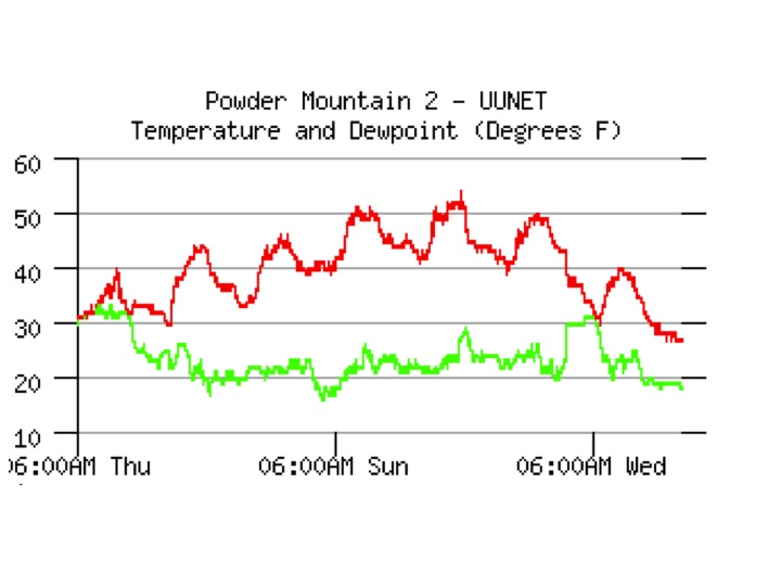
current conditions Skies are clear, and temperatures are the coolest in days – stations are in the twenties to mid 30s this morning. This will have given a hard refreeze to the snow surface, and before the snow softens today, teeth chattering conditions and “slide for life’s” are possible on steep icy slopes, with breakable crusts to be found on the high northerly facing slopes. The northeasterly winds are generally less than 15 mph, even across the highest peaks. Coolest temperatures in 7 days!
|
 |
recent activity No new avalanche activity reported from the backcountry. However, resort control work in the Cottonwoods and on the Park City side included natural and skier triggered wet loose sluffs on steep easterly and westerly facing slopes, and explosive triggered wet slides on northeasterly facing slopes, above 9,000’, up to 75’ wide and 2 ½ feet deep. |
| type | aspect/elevation | characteristics |
|---|

|

|
LIKELIHOOD
 LIKELY
UNLIKELY
SIZE
 LARGE
SMALL
TREND
 INCREASING DANGER
SAME
DECREASING DANGER
|
|
description
While the snow surface will be hard and icy this morning, wet snow still lurks beneath most slopes around the compass. Do some investigation, and find out how thick the frozen crusts are where you are traveling, and what they are sitting on – dense, consolidated snow is way stronger than slopes with wet, loose fist hard facets. Both wet slabs and wet sluffs can be triggered Thursday and Friday as the day heats up. Below - frozen crust over wet facets.
Use the usual springtime tricks - early starts and early finishes and switching to the cooler aspects once the snow heats up. First east facing slopes will heat, then south, then west and northerly. When the snow becomes punchy, soggy, wet or loose where you are, get off steep slopes and head elsewhere. Avoid terrain traps, including creeks and gullies, where even a small sluff can pile snow up deeply. Glide avalanches can occur any time of day, most common where there are smooth rock slabs beneath the snow; and cornices are sensitive and break back further than expected. |
 |
weather The great melt down will continue through the weekend, as high pressure expands over the Great Basin. Clear, sunny skies today, with ridge line temperatures warming to near 30, and 8,000’ temperatures into the mid to upper 40s. The northeasterly winds will remain light, less than 15 mph, except across the high peaks, where averages to 20 mph, with gusts to 30, are possible at times. Friday, highs will once again be back into the upper 30s along the high ridgelines, with 8,000’ highs near 50. Next chance for cooler temperatures will be with a cold front forecast for around Monday night. |
| general announcements
Remember your information can save lives. If you see anything we should know about, please participate in the creation of our own community avalanche advisory by submitting snow and avalanche conditions. You can also call us at 801-524-5304, email by clicking HERE, or include #utavy in your tweet or Instagram. If you trigger an avalanche in the backcountry - especially if you are adjacent to a ski area – please call the following teams to alert them to the slide and whether anyone is missing or not. Rescue teams can be exposed to significant hazard when responding to avalanches, and do not want to do so when unneeded. Thanks. Salt Lake and Park City – Alta Central (801-742-2033), Canyons Resort Dispatch (435-615-3322) Snowbasin Resort Dispatch (801-620-1017), Powder Mountain Dispatch (801-745-3772 x 123). Sundance Dispatch (801-223-4150) EMAIL ADVISORY If you would like to get the daily advisory by email you will need to subscribe here. DAWN PATROL Hotline updated daily by 5-530am - 888-999-4019 option 8. Twitter Updates for your mobile phone - DETAILS UDOT canyon closures: LINK TO UDOT, or on Twitter, follow @UDOTavy, @CanyonAlerts or @AltaCentral Utah Avalanche Center mobile app - Get your advisory on your iPhone along with great navigation and rescue tools. Wasatch Powderbird Guides Blog/Itinerary for the Day. Lost or Found something in the backcountry? - http://nolofo.com/ Discount lift tickets are now available at Backcountry.com. Thanks to Ski Utah and the Utah Resorts. All proceeds go towards paying for Utah Avalanche Center avalanche and mountain weather advisories. To those skinning uphill at resorts: it is your responsibility to know the resort policy on uphill travel. You can see the uphill travel policy for each resort here. IMPORTANT: Before skinning or hiking at a resort under new snow conditions, check in with Ski Patrol. Resorts can restrict or cut off access if incompatible with control and grooming operations. Benefit the Utah Avalanche Center when you shop from Backcountry.com or REI: Click this link for Backcountry.com or this link to REI, shop, and they will donate a percent of your purchase price to the UAC. Both offer free shipping (with some conditions) so this costs you nothing! Benefit the Utah Avalanche Center when you buy or sell on ebay - set the Utah Avalanche Center as a favorite non-profit in your ebay account here and click on ebay gives when you buy or sell. You can choose to have your seller fees donated to the UAC, which doesn't cost you a penny. This information does not apply to developed ski areas or highways where avalanche control is normally done. This advisory is from the U.S.D.A. Forest Service, which is solely responsible for its content. This advisory describes general avalanche conditions and local variations always exist. |


_4.jpg)