| During the month of April, Mark Miller will donate $75 to the charity of your choice (5 to chose from, including the Utah Avalanche Center!) Mark Miller Subaru has raised over $300k in the previous 6 Do Good Feel Good events. More Info here |  |
| During the month of April, Mark Miller will donate $75 to the charity of your choice (5 to chose from, including the Utah Avalanche Center!) Mark Miller Subaru has raised over $300k in the previous 6 Do Good Feel Good events. More Info here | |
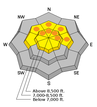
| Advisory: Ogden Area Mountains | Issued by Drew Hardesty for Tuesday - March 17, 2015 - 7:15am |
|---|

|
bottom line Areas of CONSIDERABLE danger exist in the mid and upper elevation northwest to east facing terrain for wet loose and wet slab avalanches. Human triggered wet slabs 1-3' deep remain possible. Remember it's more difficult to get untangled from flowing wet avalanches and they set up like concrete in the deposition zone. Elsewhere the danger is MODERATE.
|
 |
special announcement Colin Haley - Patagonia Dreaming: Come enjoy a slideshow presentation by alpinist Colin Haley and hear about his recent climbing expedition to Patagonia. He will also be walking us through some tips and tricks to make your life in the mountains a little easier. A must for aspiring, experienced, and armchair alpinists alike…All proceeds benefit the Utah Avalanche Center. Doors at 6:30pm, presentation starts at 7:00pm. Event held at Petzl - 2929 Decker Lake Dr |
 |
current conditions Nice spring we had this winter, eh?
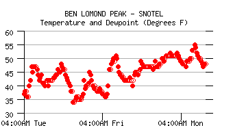
Skies are partly cloudy, winds are southwesterly blowing 10-15mph with occasional gusts to 25mph. Temps are a sore spot right now. Most stations have current overnight lows in the upper 30s and low 40s. Most if not all locations haven't seen temps at or below freezing since the morning of the 14th or the 13th. We're talking above freezing temps now for 72 - and in some cases 96 - hours. (exhibit A - Ben Lomond at 8000' - freezing temps not noted in the last week.)
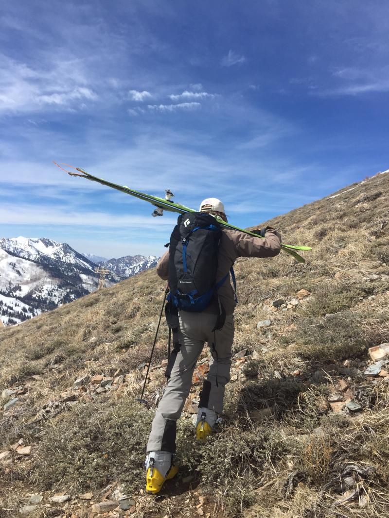
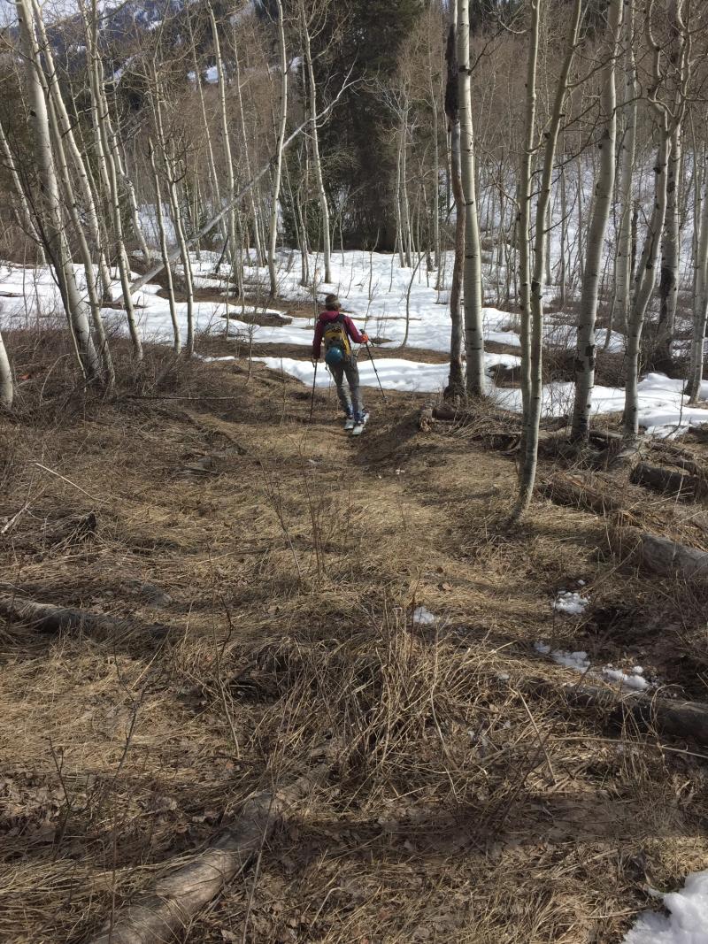
Photos above showing some of the more consistent and supportable surface conditions of the outing. |
 |
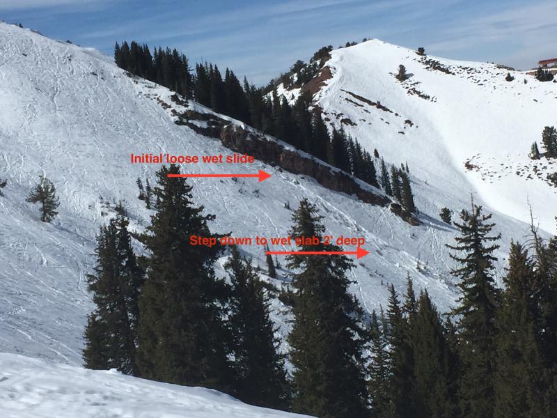
recent activity As we skinned and sometimes booted through the sage from Jupiter to 9990' yesterday, Canyons snowsafety called to relay that a lone skier without avalanche gear triggered, was caught in, and lost a ski in the Canyons periphery of Dutch Draw. In an area called Conehead on a steep east-northeast facing slope at 9500'. The initial wet loose slide quickly stepped down into a wet slab pocket 2' deep and 40' wide. It was the same location of a fatality in January 2005. Slope cuts continue to produce fair sized wet loose and wet slab avalanches up to 18-24" deep in mid and upper elevation northwest to east facing terrain.
|
| type | aspect/elevation | characteristics |
|---|

|
|
LIKELIHOOD
 LIKELY
UNLIKELY
SIZE
 LARGE
SMALL
TREND
 INCREASING DANGER
SAME
DECREASING DANGER
|
|
description
It's a combination of cloud cover, wind, and temperatures that are both complex, spatially variable, and may also vary just a few miles or so along the range (due to inconsistencies of the aforementioned weather parameters). While most of the snow we looked at yesterday was isothermal, we found wet grains along the interfaces of both the mid-February facets as well as at the top of the early season depth hoar. We also found percolation columns, the "piping and plumbing" of the spring snowpack, that allow for free water to move through areas of homogenous slabs...though the water often pools along crusts and at the interface from strong snow to weak snow. Some water/wet grains are ok...too much water is not - and this is well mirrored by the pockety wet slab activity over the past couple days. The take-home info - even with a superficial refreeze, the engine below is still sputtering. Your skis, board, or sled may briefly keep you briefly above the snow, but without you'd be post-holing in many places without their help. I'd avoid all steep west to north to southeast facing terrain today until cooler temps arrive to lock up the snowpack. Or anyplace you find yourself in unsupportable or collapsing snow.
|
 |
weather A weak disturbance may bring a touch of rain and snow tonight into tomorrow but I wouldn't bet on it. Temps at 10,000' will cool slightly, dropping to freezing tonight and the upper 20s tomorrow. Winds will be southwesterly, blowing 20mph today and diminishing after the "cold front". High pressure builds back in, with a couple weak brush-bys possible for Saturday and Tuesday. |
| general announcements
Remember your information can save lives. If you see anything we should know about, please participate in the creation of our own community avalanche advisory by submitting snow and avalanche conditions. You can also call us at 801-524-5304, email by clicking HERE, or include #utavy in your tweet or Instagram. If you trigger an avalanche in the backcountry - especially if you are adjacent to a ski area – please call the following teams to alert them to the slide and whether anyone is missing or not. Rescue teams can be exposed to significant hazard when responding to avalanches, and do not want to do so when unneeded. Thanks. Salt Lake and Park City – Alta Central (801-742-2033), Canyons Resort Dispatch (435-615-3322) Snowbasin Resort Dispatch (801-620-1017), Powder Mountain Dispatch (801-745-3772 x 123). Sundance Dispatch (801-223-4150) EMAIL ADVISORY If you would like to get the daily advisory by email you will need to subscribe here. DAWN PATROL Hotline updated daily by 5-530am - 888-999-4019 option 8. Twitter Updates for your mobile phone - DETAILS UDOT canyon closures: LINK TO UDOT, or on Twitter, follow @UDOTavy, @CanyonAlerts or @AltaCentral Utah Avalanche Center mobile app - Get your advisory on your iPhone along with great navigation and rescue tools. Wasatch Powderbird Guides Blog/Itinerary for the Day. Lost or Found something in the backcountry? - http://nolofo.com/ Discount lift tickets are now available at Backcountry.com. Thanks to Ski Utah and the Utah Resorts. All proceeds go towards paying for Utah Avalanche Center avalanche and mountain weather advisories. To those skinning uphill at resorts: it is your responsibility to know the resort policy on uphill travel. You can see the uphill travel policy for each resort here. IMPORTANT: Before skinning or hiking at a resort under new snow conditions, check in with Ski Patrol. Resorts can restrict or cut off access if incompatible with control and grooming operations. Benefit the Utah Avalanche Center when you shop from Backcountry.com or REI: Click this link for Backcountry.com or this link to REI, shop, and they will donate a percent of your purchase price to the UAC. Both offer free shipping (with some conditions) so this costs you nothing! Benefit the Utah Avalanche Center when you buy or sell on ebay - set the Utah Avalanche Center as a favorite non-profit in your ebay account here and click on ebay gives when you buy or sell. You can choose to have your seller fees donated to the UAC, which doesn't cost you a penny. This information does not apply to developed ski areas or highways where avalanche control is normally done. This advisory is from the U.S.D.A. Forest Service, which is solely responsible for its content. This advisory describes general avalanche conditions and local variations always exist. |


_4.jpg)