
| During the month of April, Mark Miller will donate $75 to the charity of your choice (5 to chose from, including the Utah Avalanche Center!) Mark Miller Subaru has raised over $300k in the previous 6 Do Good Feel Good events. More Info here |  |
| During the month of April, Mark Miller will donate $75 to the charity of your choice (5 to chose from, including the Utah Avalanche Center!) Mark Miller Subaru has raised over $300k in the previous 6 Do Good Feel Good events. More Info here | |
| Advisory: Ogden Area Mountains | Issued by Evelyn Lees for Thursday - March 12, 2015 - 7:10am |
|---|

|
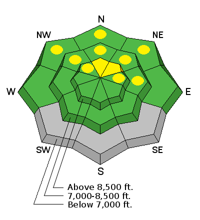
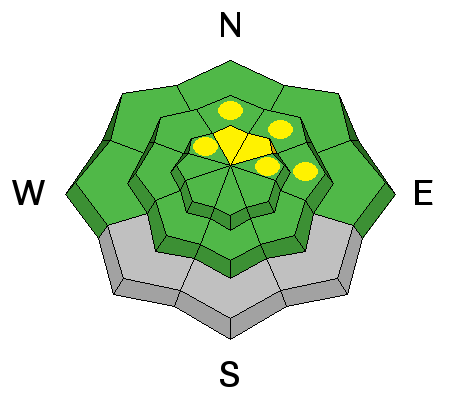
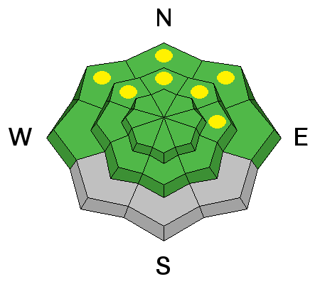
bottom line The avalanche danger is mostly LOW today, with pockets of MODERATE danger where a person could still trigger a dry slab avalanche, mostly on mid to upper elevation slopes facing northerly through easterly. Wet avalanche activity should also be minor today, but avoid steep slopes anywhere the snowpack is soggy or the surface becomes wet with daytime heating or where it is raining on the snow.
|
 |
special announcement Come check out a slideshow with Petzl Team alpinist Colin Haley at Petzl HQ (2929 Decker Lake Drive) next Tuesday March 17th 7pm about his recent climbing expedition to Patagonia. “The focus will be on this season in Patagonia, which has certainly been my most successful climbing trip ever,” Colin writes. Epic! For more information and tickets, click here. This should be an amazing event - Colin's one of the best climbers of the day - and all proceeds support the Utah Avalanche Center. |
 |
current conditions A weak disturbance crossing northern Utah is bringing scattered light snow and slightly cooler temperatures this morning. It’s currently in the twenties to mid 30s, with 1 to 2” of new snow reported at a few of the Salt Lake and Ogden area resorts. Winds are still from a westerly direction, with most stations averaging less than 10 mph. High peaks have occasional gusts in the 25 to 35 mph range. Many snow surfaces will be hard and icy this morning, and not soften too much today. |
 |
recent activity No new avalanche activity reported. |
| type | aspect/elevation | characteristics |
|---|

|
|
LIKELIHOOD
 LIKELY
UNLIKELY
SIZE
 LARGE
SMALL
TREND
 INCREASING DANGER
SAME
DECREASING DANGER
|
|
description
There is still an isolated chance of triggering a slab avalanche breaking on facets buried about 1 - 2 feet deep. Thinner snowpack areas outside are more suspect, particularly upper elevations, shallow, rocky slopes, facing northerly through easterly. As you choose your terrain, always consider what the consequences might be should you get caught in a slide. |
| type | aspect/elevation | characteristics |
|---|

|
|
LIKELIHOOD
 LIKELY
UNLIKELY
SIZE
 LARGE
SMALL
TREND
INCREASING DANGER
SAME
DECREASING DANGER
|
|
description
The snowpack is getting a short break today from the heat, courtesy of cloud cover and slightly cooler temperatures. Still, LOW danger doesn't mean NO danger. There will be places where the snow is slow to cool, and is still wet and soggy – including the shady low and mid elevations. If the snow is punchy where you are, or the surface starts to become wet and loose, it’s time to get off steep slopes. Also keep an eye on the rain/snow line, and be suspicious anytime the snow turns to rain where you are. Avoid terrain traps, including creeks and gullies at the lower elevations. |
 |
weather A weak Pacific weather disturbance will bring very light snow and slightly cooler temperatures to northern Utah today. Light snow showers will continue this morning, then become more isolated and convective this afternoon. Generally a trace to 2” of snow is expected, with a few lucky spots receiving 3 to 4”. The rain/snow line will be around 7 to 7,500’. Winds will shift to the northwest and remain light, with even the 11,000’ peaks averaging less than 20 mph. High temperatures will be near 40 at 8,000’ and in the upper 20s at 10,000’. High pressure returns on Friday; 10,000’ temperatures will be taking the long trek up, into the mid 40s by Monday. |
general announcements
|


_4.jpg)