| During the month of April, Mark Miller will donate $75 to the charity of your choice (5 to chose from, including the Utah Avalanche Center!) Mark Miller Subaru has raised over $300k in the previous 6 Do Good Feel Good events. More Info here |  |
| During the month of April, Mark Miller will donate $75 to the charity of your choice (5 to chose from, including the Utah Avalanche Center!) Mark Miller Subaru has raised over $300k in the previous 6 Do Good Feel Good events. More Info here | |
| Advisory: Ogden Area Mountains | Issued by Drew Hardesty for Wednesday - March 11, 2015 - 6:52am |
|---|


|
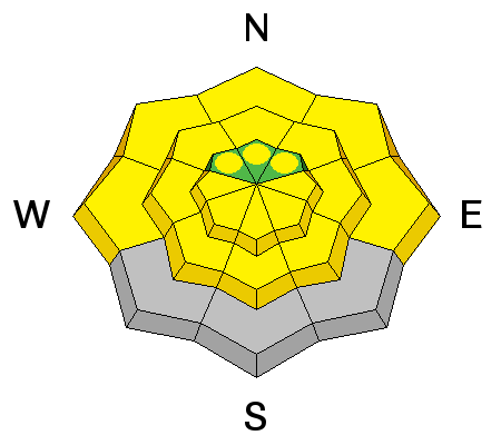
bottom line Mostly LOW danger today with MODERATE danger for wet avalanche activity NOT LIMITED TO THE SOUTHERLY ASPECTS. Watch for warning signs such as rollerballs and small sluffs. While unlikely, it may be possible to trigger a slab in thin and steep mid-to upper elevation north to east facing terrain.
|
 |
special announcement The Backcountry Film Festival is coming to Park City tonight March 11 at 7pm. The screening will be held at the Prospector Square Theater as a fundraising event for Wasatch Backcountry Alliance and the Utah Avalanche Center. Details & tickets here. Come check out a slideshow with Petzl Team alpinist Colin Haley at Petzl HQ (2929 Decker Lake Drive) next Tuesday March 17th 7pm about his recent climbing expedition to Patagonia. “The focus will be on this season in Patagonia, which has certainly been my most successful climbing trip ever,” Colin writes. Epic! For more information and tickets, click here. This should be an amazing event - Colin's one of the best climbers of the day - and all proceeds support the Utah Avalanche Center. |
 |
current conditions Today's advisory written in great part by Michael Forsyth. Spring conditions today and a warm morning in the mountains with soft recrystalized powder on sheltered northerly aspects. More southern aspects have corn conditions with solar heating. Temperatures are in the low 30's at 10,000 feet, with south winds steady at 10mph and gusts to 15. |
 |
recent activity No new avalanche activity reported.
|
| type | aspect/elevation | characteristics |
|---|

|
|
LIKELIHOOD
 LIKELY
UNLIKELY
SIZE
 LARGE
SMALL
TREND
 INCREASING DANGER
SAME
DECREASING DANGER
|
|
description
Wet avalanche activity will be likely on East to South to West aspects as the sun heats the snow. As always, if the clouds part the danger will increase. When you start to see rollerballs, its time to consider changing aspect. Some uncertainty exists with the wet issues for today, although the now-caster out on the snow will see things as they develop. The extent and development of the cloud cover may either offset or promote the wet activity. In other words, filtered sunlight trapped through thin cloud cover may promote heating (greenhousing) on the northerly aspects (even into the lower bands of the high elevations). Signs of instability will be as described above - |
| type | aspect/elevation | characteristics |
|---|

|
|
LIKELIHOOD
 LIKELY
UNLIKELY
SIZE
LARGE
SMALL
TREND
 INCREASING DANGER
SAME
DECREASING DANGER
|
|
description
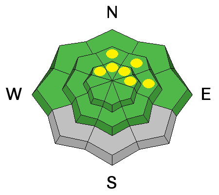
There has been no slab activity noted in the past 24 hours and the most recent activity was 3 days ago. Reports indicate this layer is stabilizing and adjusting to the current load. Still, it pays to be mindful of the presence of this layer when choosing terrain today. |
 |
weather Light cloud cover this morning, with 10k temps rising to the mid to upper 40s; 8000' temps rising to near 50. Winds will be southerly to southwesterly blowing 15-20mph with gusts to 25. Cloud cover should increase this afternoon as a weak front moves through, with some light precipitation starting late afternoon. Hopefully this system will bring us a few inches of snow to freshen up turns. We return to high pressure at the end of the week through the weekend with temps rebounding to the low to mid 50s yet again in the mountains. |
| general announcements GENERAL ANNOUNCEMENTS
Remember your information can save lives. If you see anything we should know about, please participate in the creation of our own community avalanche advisory by submitting snow and avalanche conditions. You can also call us at 801-524-5304, email by clicking HERE, or include #utavy in your tweet or Instagram. If you trigger an avalanche in the backcountry - especially if you are adjacent to a ski area – please call the following teams to alert them to the slide and whether anyone is missing or not. Rescue teams can be exposed to significant hazard when responding to avalanches, and do not want to do so when unneeded. Thanks. Salt Lake and Park City – Alta Central (801-742-2033), Canyons Resort Dispatch (435-615-3322) Snowbasin Resort Dispatch (801-620-1017), Powder Mountain Dispatch (801-745-3772 x 123). Sundance Dispatch (801-223-4150) EMAIL ADVISORY If you would like to get the daily advisory by email you will need to subscribe here. DAWN PATROL Hotline updated daily by 5-530am - 888-999-4019 option 8. Twitter Updates for your mobile phone - DETAILS UDOT canyon closures: LINK TO UDOT, or on Twitter, follow @UDOTavy, @CanyonAlerts or @AltaCentral Utah Avalanche Center mobile app - Get your advisory on your iPhone along with great navigation and rescue tools. Wasatch Powderbird Guides Blog/Itinerary for the Day. Lost or Found something in the backcountry? - http://nolofo.com/ Discount lift tickets are now available at Backcountry.com. Thanks to Ski Utah and the Utah Resorts. All proceeds go towards paying for Utah Avalanche Center avalanche and mountain weather advisories. To those skinning uphill at resorts: it is your responsibility to know the resort policy on uphill travel. You can see the uphill travel policy for each resort here. IMPORTANT: Before skinning or hiking at a resort under new snow conditions, check in with Ski Patrol. Resorts can restrict or cut off access if incompatible with control and grooming operations. Benefit the Utah Avalanche Center when you shop from Backcountry.com or REI: Click this link for Backcountry.com or this link to REI, shop, and they will donate a percent of your purchase price to the UAC. Both offer free shipping (with some conditions) so this costs you nothing! Benefit the Utah Avalanche Center when you buy or sell on ebay - set the Utah Avalanche Center as a favorite non-profit in your ebay account here and click on ebay gives when you buy or sell. You can choose to have your seller fees donated to the UAC, which doesn't cost you a penny. This information does not apply to developed ski areas or highways where avalanche control is normally done. This advisory is from the U.S.D.A. Forest Service, which is solely responsible for its content. This advisory describes general avalanche conditions and local variations always exist. |


_4.jpg)