| During the month of April, Mark Miller will donate $75 to the charity of your choice (5 to chose from, including the Utah Avalanche Center!) Mark Miller Subaru has raised over $300k in the previous 6 Do Good Feel Good events. More Info here |  |
| During the month of April, Mark Miller will donate $75 to the charity of your choice (5 to chose from, including the Utah Avalanche Center!) Mark Miller Subaru has raised over $300k in the previous 6 Do Good Feel Good events. More Info here | |
| Advisory: Ogden Area Mountains | Issued by Evelyn Lees for Wednesday - March 4, 2015 - 7:10am |
|---|

|
bottom line Avalanche danger is MODERATE on all aspects at the mid and upper elevations in the Ogden area mountains. Human triggered avalanches are possible in steep terrain. There are three different avalanche problems:
Travel Advice: Start out slow and reevaluate often. Choose tours with low angle terrain options – less steep than about 35 degrees - and reassess often, especially if you head into steeper terrain. Our below average, shallow snowpack has lots of variability.
|
 |
special announcement Backcountry Film Festival at Brewvies, Wednesday, March 4 at 7:00pm: Join us for an evening of nine unique films aimed to inspire winter adventurers to seek the snow less traveledand a killer raffle all while raising funds for the winter human powered experience. This is a benefit for Wasatch Backcountry Alliance and the Utah Avalanche Center *Brewvies is 21+. DETAILS HERE Utah Adventure Journal Snowbird Speaker Series, 6pm Mar 5 at the Wildflower Lounge: The Utah Avalanche Center will be joining the Utah Adventure Journal and friends of Jim Harris, photographer, writer, artist, avalanche observer and instructor in an evening of photos and presentations from Andrew McLean, Kalen Thorien, Noah Howell, Forest McCarthy, and Brendan Leonard. All proceeds will go towards helping to cover Jim's medical & rehab expenses following a kiting accident in Chile. Join us at Brighton Mar 7 & 8 for Vertfest! Clinics include Companion Rescue, Terrain Selection, Steep Skiing, and Mountaineering for skiers/split-boarders, both open and women-only. There will also be gear demos and the Wasatch Powder Keg ski mountaineering race, all to benefit the Utah Avalanche Center. More info here. |
 |
current conditions Skies are partly cloudy this morning, with a few final snow flurries still occurring in the Cottonwoods. Temperatures are cold – in the single digits to low teens. The west to northwesterly winds are light, in the 10-15 mph range, with gusts below 20 mph. The exception is the 11,000’ peaks, which are occasionally gusting in the low 40s. Awesome storm totals – a fairly even 16 to 24 inches of powder from the Ogden area mountains south through the Provo area mountains. Water content ranged from an inch to 1.85 inches. |
 |
recent activity There’s excellent information and photos on our Observation Page – thanks to everyone! A recap – in the Ogden area mountains, soft slabs and sluffs were easily triggered yesterday, especially during the periods of heavy snowfall and in wind drifted terrain. These were large enough to bury a person. In addition, a significant natural avalanche cycle occurred in the Provo area mountains and in upper Snake Creek/Caribou Basin (back side of Brighton), with slides breaking 2 to 3 feet deep into old snow. Numerous avalanches were triggered remotely in the Provo area mountains yesterday and on one off Soldier, on the Mill Creek ridge line, failing on facets. The Park City ridge line was very active with new snow only avalanches, both natural and skier triggered, 60 to 100' wide. |
| type | aspect/elevation | characteristics |
|---|

|
|
LIKELIHOOD
 LIKELY
UNLIKELY
SIZE
 LARGE
SMALL
TREND
 INCREASING DANGER
SAME
DECREASING DANGER
|
|
description
The new snow is rapidly stabilizing, but today you will still be able to trigger:
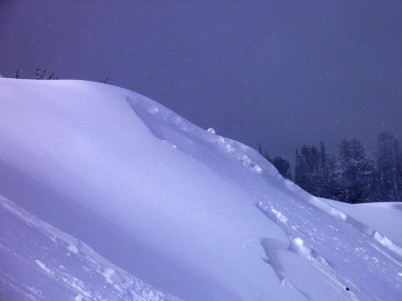
New snow slide in West Monitor, Park City mountains. M White photo
|
| type | aspect/elevation | characteristics |
|---|

|
|
LIKELIHOOD
LIKELY
UNLIKELY
SIZE
LARGE
SMALL
TREND
 INCREASING DANGER
SAME
DECREASING DANGER
|
|
description
As the strong sun comes out, the new snow will heat rapidly, and it will become easy to trigger damp sluffs. And a few natural wet sluffs may be possible, too. In areas with lingering clouds, some green housing is possible today – heating of the snow on the more northerly facing slopes. As soon as you see roller balls, or the snow where you are becomes damp or sticky, head for a cooler aspect or lower angle terrain. |
| type | aspect/elevation | characteristics |
|---|

|

|
LIKELIHOOD
 LIKELY
UNLIKELY
SIZE
 LARGE
SMALL
TREND
INCREASING DANGER
SAME
DECREASING DANGER
|
|
description
The most dangerous and unpredictable avalanche concern today is the chance of triggering a slide on a faceted snow layer. These are the slides you can trigger remotely, that can break out above you, or on the second or third person on the slope. Collapsing and cracking, indications of this problem, may or may not be present. Slopes that had a shallower snowpack before the last storm are most suspect, including wind scoured upper elevations. Tim Beaman's snow profile from 3/1 indicates there are places in the Ogden area mountains with buried facets.
|
 |
weather A few lingering light snow showers are possible this am, but skies will be clearing today, with periods of strong sun by afternoon. The northwest winds should remain light today, averaging less than 15 mph, with the highest peaks occasionally gusting into the 40s. Temperatures will remain cool – warming only into the mid 20s at 8,000’ and remaining in the single digits along the high ridge lines. We’re looking at a week of high pressure and warming temperatures, with more snow possible the middle or end of next week |
| general announcements Remember your information can save lives. If you see anything we should know about, please participate in the creation of our own community avalanche advisory by submitting snow and avalanche conditions. You can also call us at 801-524-5304, email by clicking HERE, or include #utavy in your tweet or Instagram. If you trigger an avalanche in the backcountry - especially if you are adjacent to a ski area – please call the following teams to alert them to the slide and whether anyone is missing or not. Rescue teams can be exposed to significant hazard when responding to avalanches, and do not want to do so when unneeded. Thanks. Salt Lake and Park City – Alta Central (801-742-2033), Canyons Resort Dispatch (435-615-3322) Snowbasin Resort Dispatch (801-620-1017), Powder Mountain Dispatch (801-745-3772 x 123). Sundance Dispatch (801-223-4150) EMAIL ADVISORY If you would like to get the daily advisory by email you will need to subscribe here. DAWN PATROL Hotline updated daily by 5-530am - 888-999-4019 option 8. Twitter Updates for your mobile phone - DETAILS UDOT canyon closures: LINK TO UDOT, or on Twitter, follow @UDOTavy, @CanyonAlerts or @AltaCentral Utah Avalanche Center mobile app - Get your advisory on your iPhone along with great navigation and rescue tools. Wasatch Powderbird Guides Blog/Itinerary for the Day. Lost or Found something in the backcountry? - http://nolofo.com/ Discount lift tickets are now available at Backcountry.com. Thanks to Ski Utah and the Utah Resorts. All proceeds go towards paying for Utah Avalanche Center avalanche and mountain weather advisories. To those skinning uphill at resorts: it is your responsibility to know the resort policy on uphill travel. You can see the uphill travel policy for each resort here. IMPORTANT: Before skinning or hiking at a resort under new snow conditions, check in with Ski Patrol. Resorts can restrict or cut off access if incompatible with control and grooming operations. Benefit the Utah Avalanche Center when you shop from Backcountry.com or REI: Click this link for Backcountry.com or this link to REI, shop, and they will donate a percent of your purchase price to the UAC. Both offer free shipping (with some conditions) so this costs you nothing! Benefit the Utah Avalanche Center when you buy or sell on ebay - set the Utah Avalanche Center as a favorite non-profit in your ebay account here and click on ebay gives when you buy or sell. You can choose to have your seller fees donated to the UAC, which doesn't cost you a penny. This information does not apply to developed ski areas or highways where avalanche control is normally done. This advisory is from the U.S.D.A. Forest Service, which is solely responsible for its content. This advisory describes general avalanche conditions and local variations always exist. |


_4.jpg)