
| During the month of April, Mark Miller will donate $75 to the charity of your choice (5 to chose from, including the Utah Avalanche Center!) Mark Miller Subaru has raised over $300k in the previous 6 Do Good Feel Good events. More Info here |  |
| During the month of April, Mark Miller will donate $75 to the charity of your choice (5 to chose from, including the Utah Avalanche Center!) Mark Miller Subaru has raised over $300k in the previous 6 Do Good Feel Good events. More Info here | |
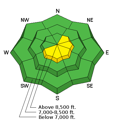
| Advisory: Ogden Area Mountains | Issued by Brett Kobernik for Tuesday - February 10, 2015 - 7:11am |
|---|

|
bottom line Most areas have a LOW avalanche danger today. There is a pockety MODERATE danger for triggering fresh wind drifts along the steep upper elevation ridges most pronounced on easterly facing slopes. Anticipate minor wet activity on upper elevation southerly slopes that received more than a trace of snow.
|
 |
current conditions The upper elevations picked up about an inch of higher density snow mid day on Monday then another inch overnight. You'll find a trace to 2 inches out there this morning. The rain-snow level was around 7500 feet during the day yesterday with damp snow accumulating at 8000 feet. Winds were from the west southwest in the moderate speed category with a few stronger gusts mid day during the snow event and then again overnight when we picked up another quick shot of snow. Temperatures are generally in the mid 20s along the mid elevations but have dropped into the upper teens along the highest peaks. |
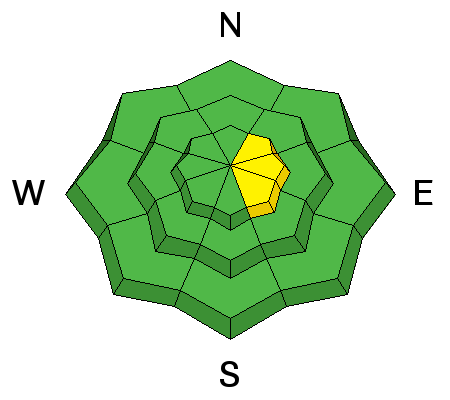
| type | aspect/elevation | characteristics |
|---|

|
|
LIKELIHOOD
 LIKELY
UNLIKELY
SIZE
 LARGE
SMALL
TREND
 INCREASING DANGER
SAME
DECREASING DANGER
|
|
description
A few stubborn wind slabs may be triggered today along the lee sides of the upper ridges. Burial is unlikely but injury is possible in high consequence terrain. Consider what is below you if a small slab would knock you around. Snowmobilers will not even notice these small slabs. |
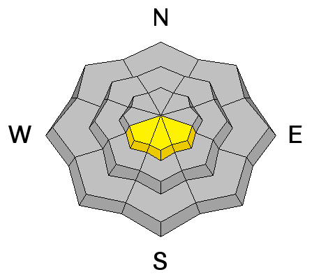
| type | aspect/elevation | characteristics |
|---|

|
|
LIKELIHOOD
LIKELY
UNLIKELY
SIZE
LARGE
SMALL
TREND
 INCREASING DANGER
SAME
DECREASING DANGER
|
|
description
A secondary minor consideration is wet avalanches. As the new snow heats up it may produce some minor wet activity today. Wet activity in areas that received the most snow could entrain enough to actually be called an avalanche. |
 |
weather We'll see partly cloudy skies today with ridgetop temperatures still above normal but slightly cooler than they have been. Highs should be in the low 30s in the 8500 foot terrain and mid 20s in the higher terrain. Winds will be from the northwest in the light to moderate category. High pressure sets in for the rest of this week into early next week with a warming trend. There are hints of storms for the middle of next week. |
| general announcements
Remember your information can save lives. If you see anything we should know about, please participate in the creation of our own community avalanche advisory by submitting snow and avalanche conditions. You can also call us at 801-524-5304, email by clicking HERE, or include #utavy in your tweet or Instagram. If you trigger an avalanche in the backcountry - especially if you are adjacent to a ski area – please call the following teams to alert them to the slide and whether anyone is missing or not. Rescue teams can be exposed to significant hazard when responding to avalanches, and do not want to do so when unneeded. Thanks. Salt Lake and Park City – Alta Central (801-742-2033), Canyons Resort Dispatch (435-615-3322) Snowbasin Resort Dispatch (801-620-1017), Powder Mountain Dispatch (801-745-3772 x 123). Sundance Dispatch (801-223-4150) EMAIL ADVISORY If you would like to get the daily advisory by email you will need to subscribe here. DAWN PATROL Hotline updated daily by 5-530am - 888-999-4019 option 8. Twitter Updates for your mobile phone - DETAILS UDOT canyon closures: LINK TO UDOT, or on Twitter, follow @UDOTavy, @CanyonAlerts or @AltaCentral Utah Avalanche Center mobile app - Get your advisory on your iPhone along with great navigation and rescue tools. Wasatch Powderbird Guides Blog/Itinerary for the Day. Lost or Found something in the backcountry? - http://nolofo.com/ Discount lift tickets are now available at Backcountry.com. Thanks to Ski Utah and the Utah Resorts. All proceeds go towards paying for Utah Avalanche Center avalanche and mountain weather advisories. To those skinning uphill at resorts: it is your responsibility to know the resort policy on uphill travel. You can see the uphill travel policy for each resort here. IMPORTANT: Before skinning or hiking at a resort under new snow conditions, check in with Ski Patrol. Resorts can restrict or cut off access if incompatible with control and grooming operations. Benefit the Utah Avalanche Center when you shop from Backcountry.com or REI: Click this link for Backcountry.com or this link to REI, shop, and they will donate a percent of your purchase price to the UAC. Both offer free shipping (with some conditions) so this costs you nothing! Benefit the Utah Avalanche Center when you buy or sell on ebay - set the Utah Avalanche Center as a favorite non-profit in your ebay account here and click on ebay gives when you buy or sell. You can choose to have your seller fees donated to the UAC, which doesn't cost you a penny. This information does not apply to developed ski areas or highways where avalanche control is normally done. This advisory is from the U.S.D.A. Forest Service, which is solely responsible for its content. This advisory describes general avalanche conditions and local variations always exist. |


_4.jpg)
