| During the month of April, Mark Miller will donate $75 to the charity of your choice (5 to chose from, including the Utah Avalanche Center!) Mark Miller Subaru has raised over $300k in the previous 6 Do Good Feel Good events. More Info here |  |
| During the month of April, Mark Miller will donate $75 to the charity of your choice (5 to chose from, including the Utah Avalanche Center!) Mark Miller Subaru has raised over $300k in the previous 6 Do Good Feel Good events. More Info here | |
| Advisory: Ogden Area Mountains | Issued by Drew Hardesty for Wednesday - February 4, 2015 - 6:56am |
|---|

|
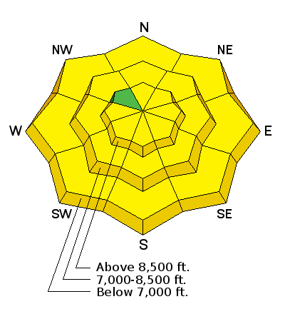
bottom line A MODERATE danger exists in the high easterly terrain for new and developing wind drifts up to a foot or so deep. The danger may be more pronounced in the Monte Cristo area east of the Huntsville valley as they've picked up more precipitation. A MODERATE danger for wet avalanches also exists at the lower elevations below 8000' in the northerly aspects. The danger of wet avalanches may rise toward CONSIDERABLE on all steep southerly to westerly aspects if we see some clearing today.
|
 |
special announcement
We've issued a Special Avalanche Bulletin for the Logan area mountains in far northern Utah and southeast Idaho. They've picked up 3.2" of precipitation in the past 48 hours. Be sure to check the current Logan area advisory if you or friends are headed that way.
|
 |
current conditions Snow, if you can believe that. Most areas have picked up another 2-4" of Sierra cement and I suspect we'll see another inch or two this morning. Truth be told, these few inches of new sit on a couple inches of similar, uh, consistency from the last couple days and it's been a blessing to smooth out the old tracks and ruts. A fresh coat of paint indeed. The rain/snow line is estimated at 7500'-8000' or so and may lower a touch this morning. Wide tracks and boards will again be the ticket today. Those on skis and boards may as well keep a touch of skin wax in the back pocket. Winds are westerly, blowing 15-20mph at most locations with the highest anemometers spinning 25mph with gusts to 45. Temps are in the upper twenties and low 30s. |
 |
recent activity None. |
| type | aspect/elevation | characteristics |
|---|

|

|
LIKELIHOOD
 LIKELY
UNLIKELY
SIZE
 LARGE
SMALL
TREND
 INCREASING DANGER
SAME
DECREASING DANGER
|
|
description
Soft but dense wind slab development can be expected along the lee of the ridgelines. These will be most pronounced on steep easterly facing terrain at the higher elevations. Yesterday's snow seemed well bonded to the underlying snow surfaces, but it'll be key to look again at the sensitivity of any new slab development. Shooting cracks are key indicators; cornice drops, test slopes, and slope cuts should also give good information in representative terrain. For more info on dealing with wind slabs, click on the 'i' next to the Wind Slab info-graphic above. |
| type | aspect/elevation | characteristics |
|---|

|
|
LIKELIHOOD
 LIKELY
UNLIKELY
SIZE
LARGE
SMALL
TREND
 INCREASING DANGER
SAME
DECREASING DANGER
|
|
description
Let me explain the method to the madness here. Continued rain-on-snow will allow for wet push-a-lanches in the steeper low-approaching-mid elevation shady slopes. The wild card will be the cloud cover, influencing both direct sun and green-housing. At this point, it'll be wait-and-see.
|
 |
weather We should be able to squeeze another inch or two out of the departing storm this morning, particularly north of I-80. Mountain temps will be in the upper 20s at 10,000' and the low 40s at 8000'. Winds should remain breezy along the exposed ridgelines, blowing 20-25mph or more from the west to northwest. High pressure nudges back in this evening through late Friday, with clearing skies and temps soaring to near 40 degrees at 10,000' by tomorrow. Another system grazes through on Saturday with another disturbance expected early next week. |
| general announcements
Remember your information can save lives. If you see anything we should know about, please participate in the creation of our own community avalanche advisory by submitting snow and avalanche conditions. You can also call us at 801-524-5304, email by clicking HERE, or include #utavy in your tweet or Instagram. If you trigger an avalanche in the backcountry - especially if you are adjacent to a ski area – please call the following teams to alert them to the slide and whether anyone is missing or not. Rescue teams can be exposed to significant hazard when responding to avalanches, and do not want to do so when unneeded. Thanks. Salt Lake and Park City – Alta Central (801-742-2033), Canyons Resort Dispatch (435-615-3322) Snowbasin Resort Dispatch (801-620-1017), Powder Mountain Dispatch (801-745-3772 x 123). Sundance Dispatch (801-223-4150) EMAIL ADVISORY If you would like to get the daily advisory by email you will need to subscribe here. DAWN PATROL Hotline updated daily by 5-530am - 888-999-4019 option 8. Twitter Updates for your mobile phone - DETAILS UDOT canyon closures: LINK TO UDOT, or on Twitter, follow @UDOTavy, @CanyonAlerts or @AltaCentral Utah Avalanche Center mobile app - Get your advisory on your iPhone along with great navigation and rescue tools. Wasatch Powderbird Guides Blog/Itinerary for the Day. Lost or Found something in the backcountry? - http://nolofo.com/ Discount lift tickets are now available at Backcountry.com. Thanks to Ski Utah and the Utah Resorts. All proceeds go towards paying for Utah Avalanche Center avalanche and mountain weather advisories. To those skinning uphill at resorts: it is your responsibility to know the resort policy on uphill travel. You can see the uphill travel policy for each resort here. IMPORTANT: Before skinning or hiking at a resort under new snow conditions, check in with Ski Patrol. Resorts can restrict or cut off access if incompatible with control and grooming operations. Benefit the Utah Avalanche Center when you shop from Backcountry.com or REI: Click this link for Backcountry.com or this link to REI, shop, and they will donate a percent of your purchase price to the UAC. Both offer free shipping (with some conditions) so this costs you nothing! Benefit the Utah Avalanche Center when you buy or sell on ebay - set the Utah Avalanche Center as a favorite non-profit in your ebay account here and click on ebay gives when you buy or sell. You can choose to have your seller fees donated to the UAC, which doesn't cost you a penny. This information does not apply to developed ski areas or highways where avalanche control is normally done. This advisory is from the U.S.D.A. Forest Service, which is solely responsible for its content. This advisory describes general avalanche conditions and local variations always exist. |


_4.jpg)