| During the month of April, Mark Miller will donate $75 to the charity of your choice (5 to chose from, including the Utah Avalanche Center!) Mark Miller Subaru has raised over $300k in the previous 6 Do Good Feel Good events. More Info here |  |
| During the month of April, Mark Miller will donate $75 to the charity of your choice (5 to chose from, including the Utah Avalanche Center!) Mark Miller Subaru has raised over $300k in the previous 6 Do Good Feel Good events. More Info here | |
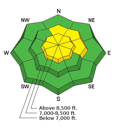
| Advisory: Ogden Area Mountains | Issued by Evelyn Lees for Friday - January 16, 2015 - 7:19am |
|---|

|
bottom line The avalanche danger is MODERATE today as the increasing winds blow snow into sensitive drifts. These cracky wind drifts will be most widespread on the north through easterly facing slopes, in the upper elevation terrain. Avoid all steep slopes with drifts of wind blown snow. Go to terrain: wind sheltered, northerly facing slopes will have that combo of soft powder and lower avalanche danger.
|
 |
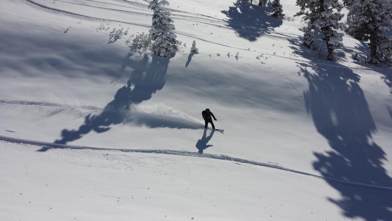
current conditions Clouds and winds are on the increase this morning ahead of a disturbance that is passing to our north. Currently, most mountain stations in the Ogden area mountains have temperatures in the mid 20s to mid 30s, and the southwesterly winds across the highest peaks have had periods with averages in the 20 to 30 mph range. Mid and upper elevation shady, northerly facing slopes have retained excellent soft powder in the Ogden area mountains (see photo below), with some of the southeast through westerly facing slopes covered in breakable crusts that will not soften today.
|
 |
recent activity The largest slide reported yesterday was another new glide avalanche in Broads Fork in Big Cottonwood Canyon - 3 feet deep by 200' wide. Other than that, only minor avalanche activity was reported from the Ogden area mountains - a very small wet sluff and a super small soft wind drift 10' across.
|
| type | aspect/elevation | characteristics |
|---|

|

|
LIKELIHOOD
 LIKELY
UNLIKELY
SIZE
 LARGE
SMALL
TREND
 INCREASING DANGER
SAME
DECREASING DANGER
|
|
description
Deepening wind slabs along ridgelines and in upper elevation terrain are the number one avalanche concern for today. The southwesterly winds will increase this morning, and be blowing in the 30 to 40 mph range across the highest terrain by around noon, when they will shift to the west and maintain their speeds. All that light powder will be fast to drift into sensitive slabs, and these drifts could become quite reactive by afternoon, and even be triggered remotely. The drifts will be widespread along ridge lines and in open bowls at the upper elevations, and more scattered at the mid elevations. If you’re in the wind zone, identify the new wind drifts by any signs of cracking or collapsing, by their pillowy and wavy shapes and stay well back from the new cornices that will be growing. |
| type | aspect/elevation | characteristics |
|---|

|

|
LIKELIHOOD
 LIKELY
UNLIKELY
SIZE
LARGE
SMALL
TREND
 INCREASING DANGER
SAME
DECREASING DANGER
|
|
description
Out of the wind-affected terrain, the avalanche danger is mostly LOW today. But stay focused on the details - minimize your exposure in areas where glide avalanches may or have been occurring (currently Broads Fork) and be prepared for sluffs on the very steep, shady slopes or scattered wind drifts in the mid elevation terrain if wind speeds increase enough. |
 |
weather A storm passing to the north will push a cold front through northern Utah this afternoon. Clouds will increase throughout the day, with a chance for light snow by late afternoon. 10,000’ temperatures will cool throughout the day, into the mid 20s. 8000’ temperatures will peak in the mid 30s. The southwesterly to westerly winds will steadily increase, with many stations having 20 mph averages by afternoon, and the highest peaks averaging 30 to 40 mph. 1-3” of snow is possible tonight south of I-80, with 2 to 5” possible north of I-80. Winds will shift to the northwest and slowly decrease after midnight. Another weak disturbance could bring a few inches of snow on Monday. |
| general announcements Remember your information can save lives. If you see anything we should know about, please participate in the creation of our own community avalanche advisory by submitting snow and avalanche conditions. You can also call us at 801-524-5304, email by clicking HERE, or include #utavy in your tweet or Instagram. If you trigger an avalanche in the backcountry - especially if you are adjacent to a ski area – please call the following teams to alert them to the slide and whether anyone is missing or not. Rescue teams can be exposed to significant hazard when responding to avalanches, and do not want to do so when unneeded. Thanks. Salt Lake and Park City – Alta Central (801-742-2033), Canyons Resort Dispatch (435-615-3322) Snowbasin Resort Dispatch (801-620-1017), Powder Mountain Dispatch (801-745-3772 x 123). Sundance Dispatch (801-223-4150) EMAIL ADVISORY If you would like to get the daily advisory by email you will need to subscribe here. DAWN PATROL Hotline updated daily by 5-530am - 888-999-4019 option 8. Twitter Updates for your mobile phone - DETAILS UDOT canyon closures: LINK TO UDOT, or on Twitter, follow @UDOTavy, @CanyonAlerts or @AltaCentral Utah Avalanche Center mobile app - Get your advisory on your iPhone along with great navigation and rescue tools. Wasatch Powderbird Guides Blog/Itinerary for the Day. Lost or Found something in the backcountry? - http://nolofo.com/ Discount lift tickets are now available at Backcountry.com. Thanks to Ski Utah and the Utah Resorts. All proceeds go towards paying for Utah Avalanche Center avalanche and mountain weather advisories. To those skinning uphill at resorts: it is your responsibility to know the resort policy on uphill travel. You can see the uphill travel policy for each resort here. IMPORTANT: Before skinning or hiking at a resort under new snow conditions, check in with Ski Patrol. Resorts can restrict or cut off access if incompatible with control and grooming operations. Benefit the Utah Avalanche Center when you shop from Backcountry.com or REI: Click this link for Backcountry.com or this link to REI, shop, and they will donate a percent of your purchase price to the UAC. Both offer free shipping (with some conditions) so this costs you nothing! Benefit the Utah Avalanche Center when you buy or sell on ebay - set the Utah Avalanche Center as a favorite non-profit in your ebay account here and click on ebay gives when you buy or sell. You can choose to have your seller fees donated to the UAC, which doesn't cost you a penny. This information does not apply to developed ski areas or highways where avalanche control is normally done. This advisory is from the U.S.D.A. Forest Service, which is solely responsible for its content. This advisory describes general avalanche conditions and local variations always exist. |


_4.jpg)