| During the month of April, Mark Miller will donate $75 to the charity of your choice (5 to chose from, including the Utah Avalanche Center!) Mark Miller Subaru has raised over $300k in the previous 6 Do Good Feel Good events. More Info here |  |
| During the month of April, Mark Miller will donate $75 to the charity of your choice (5 to chose from, including the Utah Avalanche Center!) Mark Miller Subaru has raised over $300k in the previous 6 Do Good Feel Good events. More Info here | |
| Advisory: Ogden Area Mountains | Issued by Evelyn Lees for Wednesday - January 7, 2015 - 7:18am |
|---|

|
bottom line With sun and daytime heating, the avalanche danger will rapidly rise to MODERATE for both natural and human triggered wet avalanches. Avoid travel on and below steep slopes as the snow becomes wet and soggy, especially the steep sunny aspects. Even a small wet slide can take you for a long, dangerous ride. Roof-a-lanches will continue - the dense, icy snow can slide off roofs, and could bury a person in a deep pile of snow.
|
 |
special announcement Tonight is a Black Diamond Fireside chat with Drew Hardesty at 7 pm, at the Black Diamond store. Tomorrow night, Thursday, is the Utah Adventure Journal Speaker Series featuring ice climber Will Gadd at the Wildflower Lounge at Snowbird. Details on our Events Page. You can now choose which region’s forecast you would like emailed. Sign up HERE to get the forecast of your choice. |
 |
current conditions I’m cringing at the overnight lows - in the upper 30s to mid 40s in the Ogden area mountains. However, the clear overnight skies will have helped the snow to cool - providing a hard, but shallow surface refreeze. The northerly winds are light and variable, with most stations averaging less than 10 mph. It’s spring time conditions – beautiful weather to be out cruising in the mountains, but snow conditions are variable and challenging. Breakable crusts and icy early, with the snow quickly warming to wet and sloppy on sunny slopes. Some dense powder still exists on very upper elevation due northerly facing slopes, but it’s getting rarer by the day. Arm yourself with everything from skin wax to ski crampons, depending on your timing. |
 |
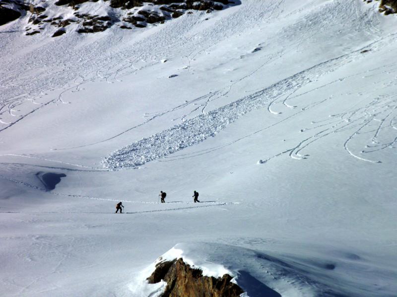
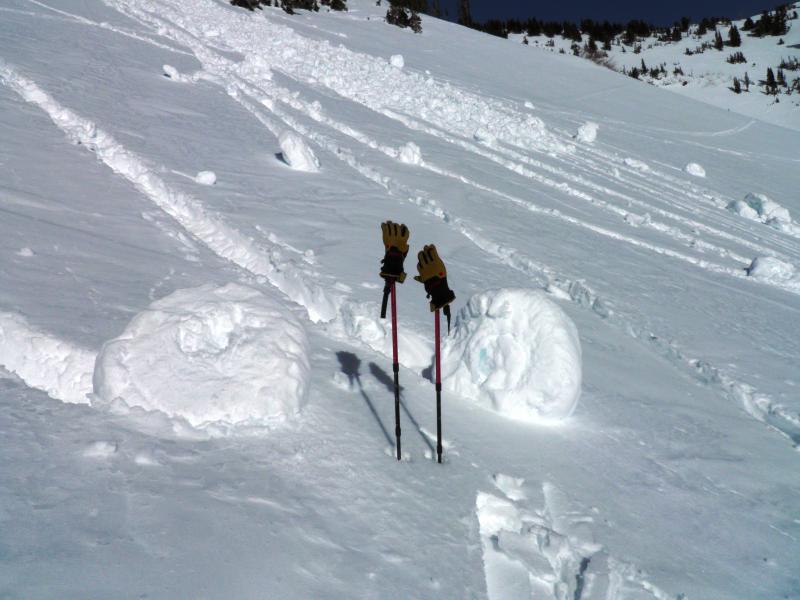
recent activity No wet avalanches were reported from the Ogden area mountains. However, there was a fairly widespread wet avalanche cycle in the Salt Lake and Provo area mountains yesterday on the steep, east through southwesterly facing slopes. Most of these were natural, spontaneous wet loose sluffs, running reasonably far as they entrained snow, and big enough to knock you over, carry you and perhaps bury you. There was also one remotely triggered hard wind slab, on Murdock peak (Park City ridge line, 9600’, NE facing), that released with a collapse from the ridge line. Mark White photos, Salt Lake area mountains. Imagine getting hit by one of those rollar balls
|
| type | aspect/elevation | characteristics |
|---|

|

|
LIKELIHOOD
 LIKELY
UNLIKELY
SIZE
 LARGE
SMALL
TREND
 INCREASING DANGER
SAME
DECREASING DANGER
|
|
description
It’s a spring time forecast – and timing is everything when it comes to wet avalanches. As the sun hits steep slopes, the snow will rapidly heat up – first on east, then south, then west, becoming wet and sloppy. The Ogden area mountains have less loose or soft snow to heat and move, but it will become easy to trigger wet loose sluffs if you are on a steep slope. With the warm overnight temperatures, these wet sluffs may gouge more deeply today, including on northerly facing slopes at the mid to low elevations. Use your springtime tricks - early starts and finishes, switch aspects as the snow heats where you are, and plan your exits to avoid the travel on and below the steep, sunny slopes as you head back to the trailhead. I'm also thinking the upper burly rain/rime crust in the Ogden mountains could make a good bed surface, and in continuous steep terrain, allow the wet sluffs to entrain snow and run fairly far. Mike Henderson profile.
|
| type | aspect/elevation | characteristics |
|---|

|

|
LIKELIHOOD
 LIKELY
UNLIKELY
SIZE
LARGE
SMALL
TREND
 INCREASING DANGER
SAME
DECREASING DANGER
|
|
description
It is January, so there is no free lunch in the backcountry. There are still weak layers in our snow pack that could be triggered in a few isolated places -
|
 |
weather Strong high pressure will remain centered over the Great Basin through the week. Today should be the warmest day, with 8,000’ temperatures near 50 and 10,000’ temperatures near 40. The northerly winds will remain light, in the 5 to 15 mph range, even at the highest elevations. Sunny again tomorrow, with a slow “cooling trend” through Friday, as temperatures drop a few degrees each day. Increasing clouds for the weekend, with a very slight chance for mountain snow. |
| general announcements Remember your information can save lives. If you see anything we should know about, please participate in the creation of our own community avalanche advisory by submitting snow and avalanche conditions. You can also call us at 801-524-5304, email by clicking HERE, or include #utavy in your tweet or Instagram. If you trigger an avalanche in the backcountry - especially if you are adjacent to a ski area – please call the following teams to alert them to the slide and whether anyone is missing or not. Rescue teams can be exposed to significant hazard when responding to avalanches, and do not want to do so when unneeded. Thanks. Salt Lake and Park City – Alta Central (801-742-2033), Canyons Resort Dispatch (435-615-3322) Snowbasin Resort Dispatch (801-620-1017), Powder Mountain Dispatch (801-745-3772 x 123). Sundance Dispatch (801-223-4150) EMAIL ADVISORY If you would like to get the daily advisory by email you will need to subscribe here. DAWN PATROL Hotline updated daily by 5-530am - 888-999-4019 option 8. Twitter Updates for your mobile phone - DETAILS UDOT canyon closures: LINK TO UDOT, or on Twitter, follow @UDOTavy, @CanyonAlerts or @AltaCentral Utah Avalanche Center mobile app - Get your advisory on your iPhone along with great navigation and rescue tools. Wasatch Powderbird Guides Blog/Itinerary for the Day. Lost or Found something in the backcountry? - http://nolofo.com/ Discount lift tickets are now available at Backcountry.com with more resorts to come soon. Thanks to Ski Utah and the Utah Resorts. All proceeds go towards paying for Utah Avalanche Center avalanche and mountain weather advisories. To those skinning uphill at resorts: it is your responsibility to know the resort policy on uphill travel. You can see the uphill travel policy for each resort here. IMPORTANT: Before skinning or hiking at a resort under new snow conditions, check in with Ski Patrol. Resorts can restrict or cut off access if incompatible with control and grooming operations. Benefit the Utah Avalanche Center when you shop from Backcountry.com or REI: Click this link for Backcountry.com or this link to REI, shop, and they will donate a percent of your purchase price to the UAC. Both offer free shipping (with some conditions) so this costs you nothing! Benefit the Utah Avalanche Center when you buy or sell on ebay - set the Utah Avalanche Center as a favorite non-profit in your ebay account here and click on ebay gives when you buy or sell. You can choose to have your seller fees donated to the UAC, which doesn't cost you a penny. This information does not apply to developed ski areas or highways where avalanche control is normally done. This advisory is from the U.S.D.A. Forest Service, which is solely responsible for its content. This advisory describes general avalanche conditions and local variations always exist. |


_4.jpg)