
| During the month of April, Mark Miller will donate $75 to the charity of your choice (5 to chose from, including the Utah Avalanche Center!) Mark Miller Subaru has raised over $300k in the previous 6 Do Good Feel Good events. More Info here |  |
| During the month of April, Mark Miller will donate $75 to the charity of your choice (5 to chose from, including the Utah Avalanche Center!) Mark Miller Subaru has raised over $300k in the previous 6 Do Good Feel Good events. More Info here | |
| Advisory: Ogden Area Mountains | Issued by Brett Kobernik for Monday - January 5, 2015 - 7:07am |
|---|

|
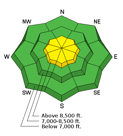
bottom line Most terrain has a LOW avalanche danger today. There is still a "pockety" MODERATE avalanche danger in the upper elevations where human triggered avalanches are still possible. Continue to treat areas with wind drifted snow as suspect. Especially watch for areas where these drifts are sitting on a shallow weak snowpack.
|
 |
special announcement Events this week include a Black Diamond Fireside chat with Drew Hardesty on Wednesday, Jan 7th and The Utah Adventure Journal Speaker Series featuring ice climber Will Gadd on Thursday, Jan 8th. For details go to our Events Page. You can now choose which region’s forecast you would like emailed. Sign up HERE to get the daily forecast emailed. |
 |
current conditions The warming trend is already noticeable with overnight ridgetop temperatures in the 20s and near freezing in the 7000 to 8000 foot range. The west winds along the higher ridges are still quite strong with gusts in the 50s. The winds continue to be more well behaved in the mid terrain but still a little gusty. Most observations from the backcountry include "variable surface conditions" with major wind damage noted in the higher terrain. Most people also include finding very nice snow in the mid and lower elevations. |
| type | aspect/elevation | characteristics |
|---|

|
|
LIKELIHOOD
 LIKELY
UNLIKELY
SIZE
 LARGE
SMALL
TREND
 INCREASING DANGER
SAME
DECREASING DANGER
|
|
description
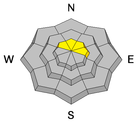
The wind slabs that formed over the last week seem to be stubborn with no one reporting any cracking or triggering even small slabs. This avalanche problem is still worth a mention today with continued winds up high. Continue to test any drifts you come across in safe terrain to give you an indication of any sensitivity that may be present. If you are getting into more radical terrain, consider consequences if a small slab does pop out on you. |
| type | aspect/elevation | characteristics |
|---|

|
|
LIKELIHOOD
 LIKELY
UNLIKELY
SIZE
LARGE
SMALL
TREND
 INCREASING DANGER
SAME
DECREASING DANGER
|
|
description
Without any avalanche activity breaking into old snow for a week now, the persistent slab problem seems like an outlier at this point. Shallow locations in the higher windy terrain is where there's a small chance for triggering something. You will also need a very steep slope approaching 40 degrees or more. |
 |
weather A storm grazing northern Utah will give us cloud cover and the chance for a few flurries today with moderate to strong west northwest winds along the ridges. It will be blustery along the higher terrain today with slightly increasing speeds mid day. Ridgetop high temperatures will get into the mid to upper 20s. Things clear out Tuesday with high pressure moving in. This brings mostly clear skies and very mild temperatures through Friday. Temperatures cool off a bit next weekend when a minor disturbance moves through. |
| general announcements Remember your information can save lives. If you see anything we should know about, please participate in the creation of our own community avalanche advisory by submitting snow and avalanche conditions. You can also call us at 801-524-5304, email by clicking HERE, or include #utavy in your tweet or Instagram. If you trigger an avalanche in the backcountry - especially if you are adjacent to a ski area – please call the following teams to alert them to the slide and whether anyone is missing or not. Rescue teams can be exposed to significant hazard when responding to avalanches, and do not want to do so when unneeded. Thanks. Salt Lake and Park City – Alta Central (801-742-2033), Canyons Resort Dispatch (435-615-3322) Snowbasin Resort Dispatch (801-620-1017), Powder Mountain Dispatch (801-745-3772 x 123). Sundance Dispatch (801-223-4150) EMAIL ADVISORY If you would like to get the daily advisory by email you will need to subscribe here. DAWN PATROL Hotline updated daily by 5-530am - 888-999-4019 option 8. Twitter Updates for your mobile phone - DETAILS UDOT canyon closures: LINK TO UDOT, or on Twitter, follow @UDOTavy, @CanyonAlerts or @AltaCentral Utah Avalanche Center mobile app - Get your advisory on your iPhone along with great navigation and rescue tools. Wasatch Powderbird Guides Blog/Itinerary for the Day. Lost or Found something in the backcountry? - http://nolofo.com/ Discount lift tickets are now available at Backcountry.com with more resorts to come soon. Thanks to Ski Utah and the Utah Resorts. All proceeds go towards paying for Utah Avalanche Center avalanche and mountain weather advisories. To those skinning uphill at resorts: it is your responsibility to know the resort policy on uphill travel. You can see the uphill travel policy for each resort here. IMPORTANT: Before skinning or hiking at a resort under new snow conditions, check in with Ski Patrol. Resorts can restrict or cut off access if incompatible with control and grooming operations. Benefit the Utah Avalanche Center when you shop from Backcountry.com or REI: Click this link for Backcountry.com or this link to REI, shop, and they will donate a percent of your purchase price to the UAC. Both offer free shipping (with some conditions) so this costs you nothing! Benefit the Utah Avalanche Center when you buy or sell on ebay - set the Utah Avalanche Center as a favorite non-profit in your ebay account here and click on ebay gives when you buy or sell. You can choose to have your seller fees donated to the UAC, which doesn't cost you a penny. This information does not apply to developed ski areas or highways where avalanche control is normally done. This advisory is from the U.S.D.A. Forest Service, which is solely responsible for its content. This advisory describes general avalanche conditions and local variations always exist. |


_4.jpg)