
| During the month of April, Mark Miller will donate $75 to the charity of your choice (5 to chose from, including the Utah Avalanche Center!) Mark Miller Subaru has raised over $300k in the previous 6 Do Good Feel Good events. More Info here |  |
| During the month of April, Mark Miller will donate $75 to the charity of your choice (5 to chose from, including the Utah Avalanche Center!) Mark Miller Subaru has raised over $300k in the previous 6 Do Good Feel Good events. More Info here | |
| Advisory: Ogden Area Mountains | Issued by Evelyn Lees for Sunday - January 4, 2015 - 6:43am |
|---|

|
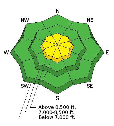
bottom line The avalanche danger is MODERATE on any steep slopes with drifts of wind-blown snow, which may be hard and cracky. These drifts will be most widespread in upper elevation terrain, especially along the ridge lines. The danger is also MODERATE for the isolated chance of triggering a deeper slide on upper elevation slopes facing northwest through east, that would break on a buried layer of weak faceted snow.
|
 |
special announcement Events this week include a Black Diamond Fireside chat with Drew Hardesty on Wednesday, Jan 7th and The Utah Adventure Journal Speaker Series featuring ice climber Will Gadd on Thursday, Jan 8th. For details go to our Events Page. You can now choose which region’s forecast you would like emailed. Sign up HERE to get the daily forecast emailed. |
 |
current conditions Skies are overcast in the Ogden area mountains, and temperatures have dropped into the teens and low twenties this morning. The southwesterly winds are brisk across the highest peaks, with averages in the 30s and 40s. But again like yesterday, speeds drop off very nicely once you get off the highest ridges, with 15 to 20 mph averages more common. The softest snow continues to be found on shady, wind sheltered slopes. (Bill Hunt photo)
|
 |
recent activity No avalanches were reported from the backcountry yesterday. |
| type | aspect/elevation | characteristics |
|---|

|

|
LIKELIHOOD
 LIKELY
UNLIKELY
SIZE
 LARGE
SMALL
TREND
 INCREASING DANGER
SAME
DECREASING DANGER
|
|
description
The most likely slide you will trigger today would be an old hard wind slab along a ridge line or in upper elevation terrain. With strong wind events this past week from almost all directions, you’ll find these drifts scattered on a variety of aspects. The consequences of even a short ride can vary dramatically depending on your terrain – a ride off a cliff, into trees or through a rocky chute is very different from a slide down a short open slope. |
| type | aspect/elevation | characteristics |
|---|

|
|
LIKELIHOOD
 LIKELY
UNLIKELY
SIZE
LARGE
SMALL
TREND
 INCREASING DANGER
SAME
DECREASING DANGER
|
|
description
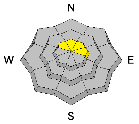
With poor snowpack structure (strong layers of snow sitting on weaker, faceted layers), there are still isolated places where a deeper slide could be triggered in upper elevation terrain facing northwest through east, especially northeasterly facing. Steep slopes with a shallower snowpack and rocky areas are suspect. Again, consider the potential consequences of a ride as you choose your line. |
 |
weather A moist but stable northwest flow will be over northern Utah through Monday. Skies will be partly to mostly cloudy, with chances for very light snow at times. Today, the best chance for snow will be along the Utah/Idaho border, tonight and tomorrow, an inch or two of snow is possible throughout the northern mountains. The westerly winds will remain strong along the high ridgelines through Monday, before finally decreasing. 35 to 45 mph averages at times, with gusts to 65. Off the ridge lines, speeds will be much less once again - 15 to 20 mph averages. Highs temperatures today will be near 30 at 8,000’ and in the teens at along the high ridges. A major warm up is still forecast for Wednesday through Thursday. |
| general announcements Remember your information can save lives. If you see anything we should know about, please participate in the creation of our own community avalanche advisory by submitting snow and avalanche conditions. You can also call us at 801-524-5304, email by clicking HERE, or include #utavy in your tweet or Instagram. If you trigger an avalanche in the backcountry - especially if you are adjacent to a ski area – please call the following teams to alert them to the slide and whether anyone is missing or not. Rescue teams can be exposed to significant hazard when responding to avalanches, and do not want to do so when unneeded. Thanks. Salt Lake and Park City – Alta Central (801-742-2033), Canyons Resort Dispatch (435-615-3322) Snowbasin Resort Dispatch (801-620-1017), Powder Mountain Dispatch (801-745-3772 x 123). Sundance Dispatch (801-223-4150) EMAIL ADVISORY If you would like to get the daily advisory by email you will need to subscribe here. DAWN PATROL Hotline updated daily by 5-530am - 888-999-4019 option 8. Twitter Updates for your mobile phone - DETAILS UDOT canyon closures: LINK TO UDOT, or on Twitter, follow @UDOTavy, @CanyonAlerts or @AltaCentral Utah Avalanche Center mobile app - Get your advisory on your iPhone along with great navigation and rescue tools. Wasatch Powderbird Guides Blog/Itinerary for the Day. Lost or Found something in the backcountry? - http://nolofo.com/ Discount lift tickets are now available at Backcountry.com with more resorts to come soon. Thanks to Ski Utah and the Utah Resorts. All proceeds go towards paying for Utah Avalanche Center avalanche and mountain weather advisories. To those skinning uphill at resorts: it is your responsibility to know the resort policy on uphill travel. You can see the uphill travel policy for each resort here. IMPORTANT: Before skinning or hiking at a resort under new snow conditions, check in with Ski Patrol. Resorts can restrict or cut off access if incompatible with control and grooming operations. Benefit the Utah Avalanche Center when you shop from Backcountry.com or REI: Click this link for Backcountry.com or this link to REI, shop, and they will donate a percent of your purchase price to the UAC. Both offer free shipping (with some conditions) so this costs you nothing! Benefit the Utah Avalanche Center when you buy or sell on ebay - set the Utah Avalanche Center as a favorite non-profit in your ebay account here and click on ebay gives when you buy or sell. You can choose to have your seller fees donated to the UAC, which doesn't cost you a penny. This information does not apply to developed ski areas or highways where avalanche control is normally done. This advisory is from the U.S.D.A. Forest Service, which is solely responsible for its content. This advisory describes general avalanche conditions and local variations always exist. |


_4.jpg)
