| During the month of April, Mark Miller will donate $75 to the charity of your choice (5 to chose from, including the Utah Avalanche Center!) Mark Miller Subaru has raised over $300k in the previous 6 Do Good Feel Good events. More Info here |  |
| During the month of April, Mark Miller will donate $75 to the charity of your choice (5 to chose from, including the Utah Avalanche Center!) Mark Miller Subaru has raised over $300k in the previous 6 Do Good Feel Good events. More Info here | |
| Advisory: Ogden Area Mountains | Issued by Brett Kobernik for Friday - January 2, 2015 - 7:24am |
|---|

|
bottom line There is an overall moderate avalanche danger today outside of the wind it affected terrain. Human triggered avalanches are possible today. The danger is a greater in the higher terrain where the recent wind has deposited and drifted snow. Avoid steep slopes with any thick snow or 'pillowy' looking drifts.
|
 |
current conditions Temperatures are as warm as they have been recently with most stations in the upper teens to around 20°. Currently, the northeast winds are still blowing with moderate speeds still along the higher terrain . These winds have cause extensive damage and drifting in many locations, most notably along the higher terrain above around 10,000 feet. Outside of the wind affected areas, riding conditions remain excellent. Some southerly aspects will most likely have a melt freeze crust on them this morning. Overall, the snowpack is trending toward a more stable condition, however, we need to give areas that have seen wind damage respect. These areas will be obvious with poor riding conditions present there. If you encounter thick snow or crusty conditions, this should alert you that you are in terrain where wind transport has been occurring. |
 |
recent activity The east winds and drifting snow caused a little avalanche activity Thursday. A few class one natural wind slabs were noted and one larger natural off of high Timpanogus was also viewed. |
| type | aspect/elevation | characteristics |
|---|

|
|
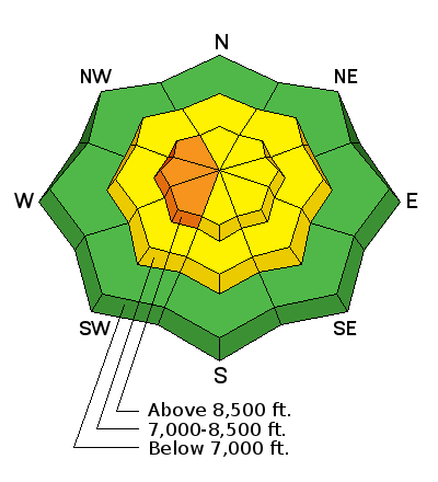
LIKELIHOOD
 LIKELY
UNLIKELY
SIZE
 LARGE
SMALL
TREND
 INCREASING DANGER
SAME
DECREASING DANGER
|
|
description
The avalanche danger varies greatly between areas that have seen the wind damage and those areas that have not. In the high Alpine terrain, east winds have loaded west facing slopes which are thin and hold faceted snow. There has been some cross loading as well on other aspects most notably southern and northern facing slopes. This is a major concern. These fresh drifts are fairly new and need some time to settle and stabilize. |
| type | aspect/elevation | characteristics |
|---|

|
|
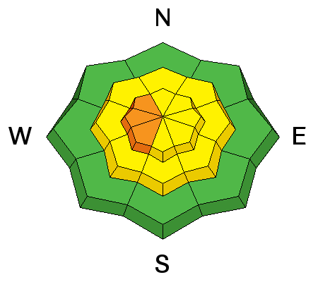
LIKELIHOOD
 LIKELY
UNLIKELY
SIZE
LARGE
SMALL
TREND
INCREASING DANGER
SAME
DECREASING DANGER
|
|
description
The trend is for more stable conditions for our mid and basal faceted weak layers but it still needs to be mentioned it today. Personally, I like to let these persistent weak layers settle longer than most people do. Certainly, things are not hair trigger right now but weak layers can still be observed and shown in snow pit testing. Recent wind loading enhances this issue. |
 |
weather For mountain weather we will have a gorgeous day out there today with warmer temperatures and wind speeds slowing and backing to the north and northwest eventually. A "brush-by" storm will pass tomorrow clipping northern Utah bringing clouds and the chance for flurries without much accumulations anticipated. |
| general announcements
Remember your information can save lives. If you see anything we should know about, please participate in the creation of our own community avalanche advisory by submitting snow and avalanche conditions. You can also call us at 801-524-5304, email by clicking HERE, or include #utavy in your tweet or Instagram. If you trigger an avalanche in the backcountry - especially if you are adjacent to a ski area – please call the following teams to alert them to the slide and whether anyone is missing or not. Rescue teams can be exposed to significant hazard when responding to avalanches, and do not want to do so when unneeded. Thanks. Salt Lake and Park City – Alta Central (801-742-2033), Canyons Resort Dispatch (435-615-3322) Snowbasin Resort Dispatch (801-620-1017), Powder Mountain Dispatch (801-745-3772 x 123). Sundance Dispatch (801-223-4150) EMAIL ADVISORY If you would like to get the daily advisory by email you will need to subscribe here. DAWN PATROL Hotline updated daily by 5-530am - 888-999-4019 option 8. Twitter Updates for your mobile phone - DETAILS UDOT canyon closures: LINK TO UDOT, or on Twitter, follow @UDOTavy, @CanyonAlerts or @AltaCentral Utah Avalanche Center mobile app - Get your advisory on your iPhone along with great navigation and rescue tools. Wasatch Powderbird Guides Blog/Itinerary for the Day. Lost or Found something in the backcountry? - http://nolofo.com/ Discount lift tickets are now available at Backcountry.com with more resorts to come soon. Thanks to Ski Utah and the Utah Resorts. All proceeds go towards paying for Utah Avalanche Center avalanche and mountain weather advisories. To those skinning uphill at resorts: it is your responsibility to know the resort policy on uphill travel. You can see the uphill travel policy for each resort here. IMPORTANT: Before skinning or hiking at a resort under new snow conditions, check in with Ski Patrol. Resorts can restrict or cut off access if incompatible with control and grooming operations. Benefit the Utah Avalanche Center when you shop from Backcountry.com or REI: Click this link for Backcountry.com or this link to REI, shop, and they will donate a percent of your purchase price to the UAC. Both offer free shipping (with some conditions) so this costs you nothing! Benefit the Utah Avalanche Center when you buy or sell on ebay - set the Utah Avalanche Center as a favorite non-profit in your ebay account here and click on ebay gives when you buy or sell. You can choose to have your seller fees donated to the UAC, which doesn't cost you a penny. This information does not apply to developed ski areas or highways where avalanche control is normally done. This advisory is from the U.S.D.A. Forest Service, which is solely responsible for its content. This advisory describes general avalanche conditions and local variations always exist. |


_4.jpg)