| During the month of April, Mark Miller will donate $75 to the charity of your choice (5 to chose from, including the Utah Avalanche Center!) Mark Miller Subaru has raised over $300k in the previous 6 Do Good Feel Good events. More Info here |  |
| During the month of April, Mark Miller will donate $75 to the charity of your choice (5 to chose from, including the Utah Avalanche Center!) Mark Miller Subaru has raised over $300k in the previous 6 Do Good Feel Good events. More Info here | |
| Advisory: Ogden Area Mountains | Issued by Evelyn Lees for Sunday - December 28, 2014 - 7:20am |
|---|

|
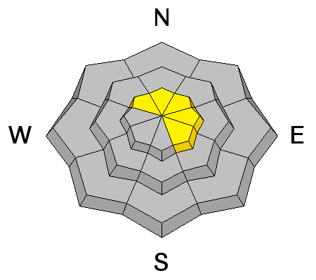
bottom line The avalanche danger is CONSIDERABLE on upper elevation slopes facing northwest through east, where winds will be building sensitive drifts of snow. In very isolated places - upper elevation slopes facing northwest through southeast - in the Ogden area mountains, these drifts could overload buried weak layers, and larger slides 2 to 3 feet deep are possible. In addition, avoid any steep slopes with recent drifts of wind-blown snow, which you will find at both mid and upper elevations. Lower avalanche danger and excellent riding conditions will be found in wind sheltered terrain, and on the low angle slopes of all aspects.
|
 |
special announcement CHECK IT OUT!! This SHORT VIDEO is an insightful look into the world of veteran Snowbasin ski patroller, GR Fletcher. Ogden-based filmmaker Chris Morgan followed GR during a morning of avalanche control work on the mountain as he explained what motivates him to continue as a patroller after over twenty years on the job. |
 |
current conditions A cold winter storm is nudging into northern Utah this morning, and light snow is falling in the mountains. Temperatures have warmed into the teens in the Ogden area mountains, with only a few higher elevation stations hanging on to single digits. The west to southwesterly winds have ramped up, with many stations averaging 15 to 20 mph; a few of the highest peaks briefly averaged 35 mph, with gusts to 50. |
 |
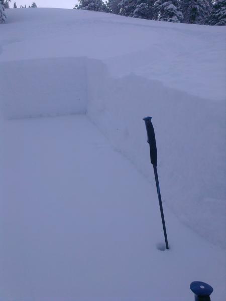
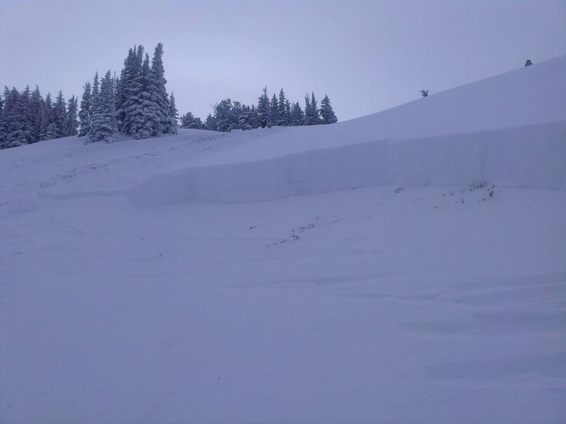
recent activity Yesterday, lots of steep terrain was traveled in the backcountry with no incidents. But one hard slab avalanche was triggered by the third skier in Wilson Glade, Mill Creek Canyon, on a northeast facing slope at 9,400'. It was about 3 feet deep by 100’ wide, and failed on a mid-pack December weak layer, not the facets on the ground. An excellent report is HERE. Detailed snow pack information on the Dutch Draw incident is HERE. Wilson Glade avalanche. Most of the slope was lower angle, 33 degrees and below, with one 35 degree section. |
| type | aspect/elevation | characteristics |
|---|

|
|
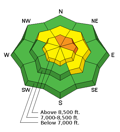
LIKELIHOOD
 LIKELY
UNLIKELY
SIZE
 LARGE
SMALL
TREND
 INCREASING DANGER
SAME
DECREASING DANGER
|
|
description
With abundant snow available for the winds to blow and drift, new wind slabs are quickly forming and are the main avalanche concern today. The drifts will be most widespread along the high ridges on slopes facing northwest through southeast, but watch for cross loading on other aspects and drifts at the mid elevations. Cross loading means that snow will often pile up along gully walls, just below slope break overs, and around small ribs and ridges. Most of these drifts will be soft, but as they deepen during the day and overnight, they will become more dense, sensitive and cracky. |
| type | aspect/elevation | characteristics |
|---|

|
|
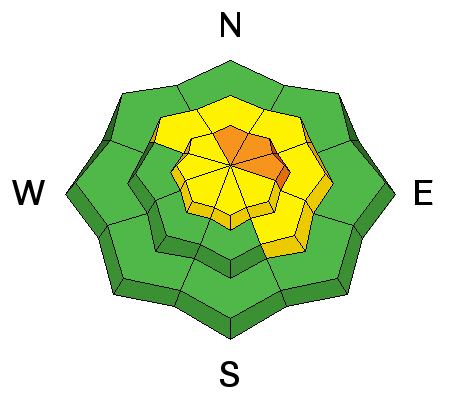
LIKELIHOOD
 LIKELY
UNLIKELY
SIZE
LARGE
SMALL
TREND
INCREASING DANGER
SAME
DECREASING DANGER
|
|
description
The trend towards the stability of the deeper weak layers has been temporarily halted today as winds load extra snow onto slopes facing northeast and east. While the new snow will be very low density, wind drifts by late afternoon and overnight can double or triple the weight on a slope. A deeper slab could be triggered by a person, either on slope or remotely, or be triggered by a smaller wind slab avalanche that then steps down. Trying to identify slopes that have a deeper, stronger snowpack from those that are shallow, with persistent weak layers is hard. Avoiding steep slopes in upper elevation terrain facing northwest through east, especially wind drifted slopes, is the best way to handle this complex pattern. |
 |
weather A cold winter storm is settling into northern Utah, and will bring snow today through Monday. Light snowfall this morning will become heavier this afternoon and tonight. 2 to 5” of snow expected today, with another 4 to 8” tonight. The westerly winds will be strongest this morning, with most stations averaging 20 to 25 mph at times. The highest peaks could average to 45 mph, with gusts to 60. The winds will decrease slightly by mid-day, but still be annoying. Temperatures will be in the teens today, dropping into the single digits tonight. There will be a few lingering snow showers on Monday, before the flow turns easterly and shuts off the snow. A very cold arctic air mass will be in place through at least mid-week. |
| general announcements Remember your information can save lives. If you see anything we should know about, please participate in the creation of our own community avalanche advisory by submitting snow and avalanche conditions. You can also call us at 801-524-5304, email by clicking HERE, or include #utavy in your tweet or Instagram. If you trigger an avalanche in the backcountry - especially if you are adjacent to a ski area – please call the following teams to alert them to the slide and whether anyone is missing or not. Rescue teams can be exposed to significant hazard when responding to avalanches, and do not want to do so when unneeded. Thanks. Salt Lake and Park City – Alta Central (801-742-2033), Canyons Resort Dispatch (435-615-3322) Snowbasin Resort Dispatch (801-620-1017), Powder Mountain Dispatch (801-745-3772 x 123). Sundance Dispatch (801-223-4150) EMAIL ADVISORY If you would like to get the daily advisory by email you will need to subscribe here. DAWN PATROL Hotline updated daily by 5-530am - 888-999-4019 option 8. Twitter Updates for your mobile phone - DETAILS UDOT canyon closures: LINK TO UDOT Utah Avalanche Center mobile app - Get your advisory on your iPhone along with great navigation and rescue tools. Wasatch Powderbird Guides Blog/Itinerary for the Day. Lost or Found something in the backcountry? - http://nolofo.com/ Discount lift tickets are now available at Backcountry.com with more resorts to come soon. Thanks to Ski Utah and the Utah Resorts. All proceeds go towards paying for Utah Avalanche Center avalanche and mountain weather advisories. To those skinning uphill at resorts: it is your responsibility to know the resort policy on uphill travel. You can see the uphill travel policy for each resort here. IMPORTANT: Before skinning or hiking at a resort under new snow conditions, check in with Ski Patrol. Resorts can restrict or cut off access if incompatible with control and grooming operations. Benefit the Utah Avalanche Center when you shop from Backcountry.com or REI: Click this link for Backcountry.com or this link to REI, shop, and they will donate a percent of your purchase price to the UAC. Both offer free shipping (with some conditions) so this costs you nothing! Benefit the Utah Avalanche Center when you buy or sell on ebay - set the Utah Avalanche Center as a favorite non-profit in your ebay account here and click on ebay gives when you buy or sell. You can choose to have your seller fees donated to the UAC, which doesn't cost you a penny. This information does not apply to developed ski areas or highways where avalanche control is normally done. This advisory is from the U.S.D.A. Forest Service, which is solely responsible for its content. This advisory describes general avalanche conditions and local variations always exist |


_4.jpg)