| During the month of April, Mark Miller will donate $75 to the charity of your choice (5 to chose from, including the Utah Avalanche Center!) Mark Miller Subaru has raised over $300k in the previous 6 Do Good Feel Good events. More Info here |  |
| During the month of April, Mark Miller will donate $75 to the charity of your choice (5 to chose from, including the Utah Avalanche Center!) Mark Miller Subaru has raised over $300k in the previous 6 Do Good Feel Good events. More Info here | |
| Advisory: Ogden Area Mountains | Issued by Drew Hardesty for Wednesday - December 24, 2014 - 7:22am |
|---|

|
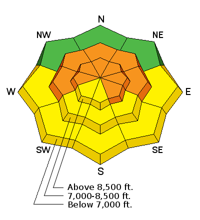
bottom line Pockets of CONSIDERABLE danger exist on the west to north to southeast facing terrain above about 9000'. Human triggered avalanches up to 3' deep are possible and may be triggered at a distance. Watch for overnight wind drifts along the higher elevations and any potential for wet loose sluffs on the steepest sun-kissed terrain.
|
 |
special announcement Discount lift tickets are in and for sale - ski a day at the resorts and benefit the Utah Avalanche Center. Tickets for Alta, Brighton, Deer Valley, Solitude, and Snowbasin, Snowbird, and Sundance are in and more tickets are expected shortly. Discount Epic lift tickets for Park City Mountain Resort and Canyons are now in - order now from Backcountry.com Riding chairs and going out of bounds through the exit gates? You're Stepping Into Areas of Considerable Danger -
|
 |
current conditions Skies are partly cloudy; winds are westerly and generally less than 15mph. Temps have been on the upward march and are in the upper teens and low 20s. Snow coverage has improved greatly, though the low elevations paid a price. Snow depths now average 3-5' in the mid and upper elevations though the now shallowly buried rain crust extends to 8000' or so.
|
 |
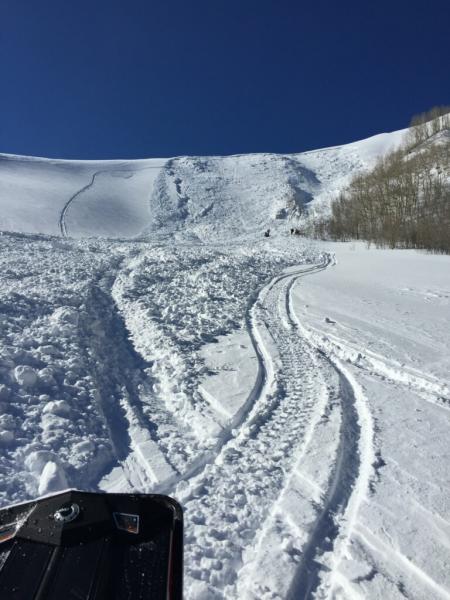
recent activity While the avalanche control teams continued to trigger large eye-opening avalanches yesterday, the backcountry was relatively quiet. We only heard-through-the-grapevine of one sled-triggered slide on the Wasatch backside in the Lavina drainage of Snake Creek, there above Midway. Best estimates are 2-3' deep and 150' wide on a east facing slope at 9000'. Clear skies provided excellent view of the carnage from Sunday/Monday - Kory Davis has a couple good pics here. The natural cycle is in the rear-view mirror and truth-be-told, the stability is improving....but there was another reason for only one reported human triggered slide in the Central Wasatch (none in the Ogden mts) yesterday - a couple of hints below (photos Mark White, Nick Norris).
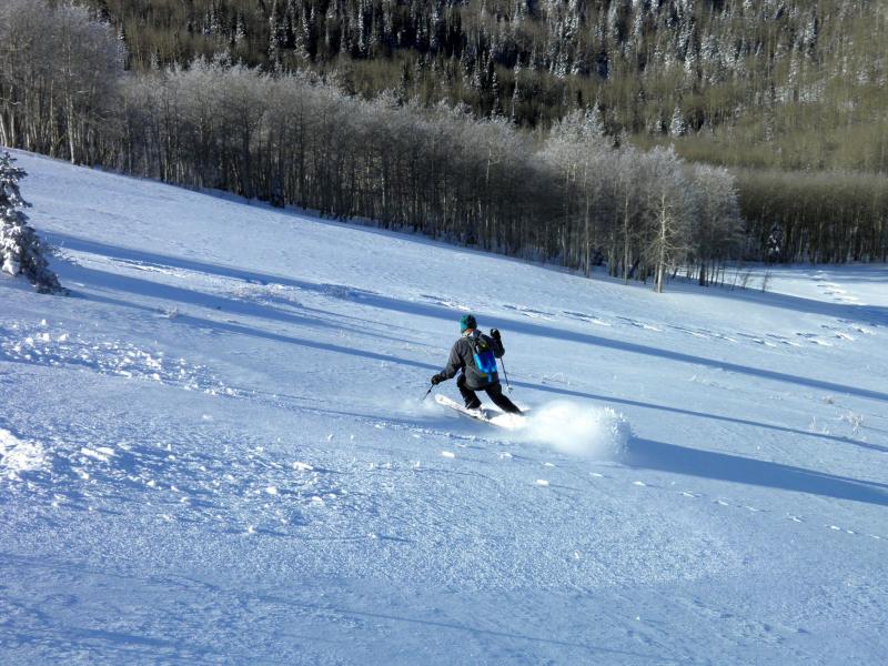
Yep - you guessed it - we call it "Low Angle Love" - most were staying on ridgelines or on slopes gentler than 30 degrees steepness. It's why the guy on the left - Brad Makoff - has been able to backcountry ski 100 days a winter for 40 years. Bump up the the slope angle to 35-45 degrees? Yesterday's results below -
|
| type | aspect/elevation | characteristics |
|---|

|
|
LIKELIHOOD
 LIKELY
UNLIKELY
SIZE
 LARGE
SMALL
TREND
 INCREASING DANGER
SAME
DECREASING DANGER
|
|
description
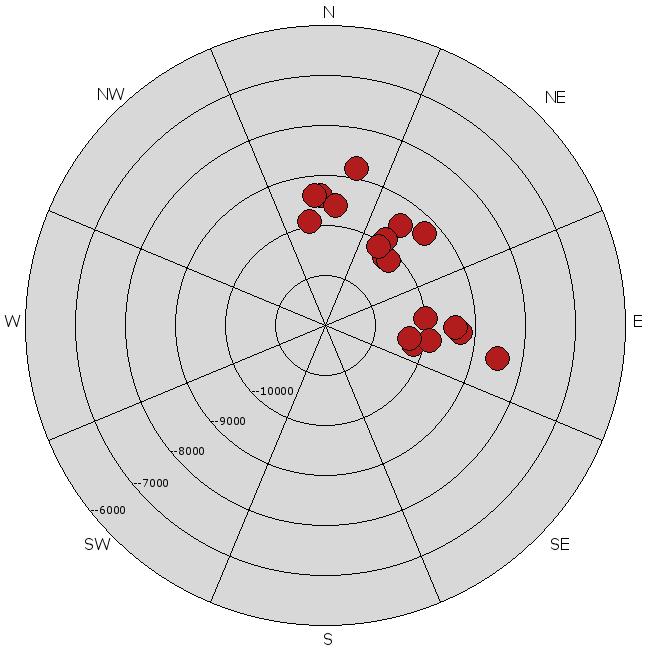
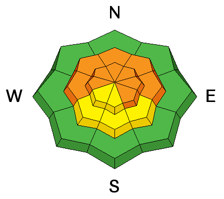
I suspect that most of the storm and wind slabs have healed nicely; however there's more to the picture. More slow to heal are the interfaces down a foot or two on the early December facets...a recent rime crust interface and to a lesser extent the early to mid-November weaknesses, particularly areas that avalanched during the cycle about a month ago. At this point, I'd continue to show patience and allow these lingering weaknesses to heal and choose low consequence terrain. Test slopes, cornice drops, slope cuts and other tracks on the slope can be unreliable -click on the 'i' next to the icon for more info. Below is the backcountry avalanche activity rose from 12/21 - yesterday. It should be noted that many slides reported as east facing continued wrapping around into southeast facing terrain. Photo of naturals off Ben Lomond by Lee Fortin.
|
| type | aspect/elevation | characteristics |
|---|

|

|
LIKELIHOOD
LIKELY
UNLIKELY
SIZE
 LARGE
SMALL
TREND
INCREASING DANGER
SAME
DECREASING DANGER
|
|
description
Overnight winds along the more exposed ridgelines showcased hourly averages in the 20-30mph range with gusts to the upper 30s and low 40s; they've since dropped off but should pick back up preceding tomorrow morning's cold front. If in the high country today, expect to see some wind slab development up to a foot or so and found in typical lee terrain just off the ridgelines. Test slopes, cornice drops, slope cuts and other tracks tend to provide some good info here -click on the 'i' next to the icon for more info. |
| type | aspect/elevation | characteristics |
|---|

|
|
LIKELIHOOD
 LIKELY
UNLIKELY
SIZE
 LARGE
SMALL
TREND
 INCREASING DANGER
SAME
DECREASING DANGER
|
|
description
Worth a mention - rapid warming today should push 10,000' temps into the low 30s with 8000' temps into the low 40s. These temps, conspiring with direct sun, will dampen and loosen the bonds in the upper few inches of snow on the steeper sunlit terrain. Keep an eye on cloud cover, potential for greenhousing, and how the snow is being affected and adjust your route selections accordingly. |
 |
weather We'll have increasing clouds, increasing southwest winds, and warming temps ahead of tomorrow's Christmas storm. Wrapped in a bow, this'll be low density icing on the cake - a classic Wasatch storm out of the northwest. The cold front arrives early morning and should be good for about a foot or so. Today's temps in the low 30s and low 40s will plummet to the upper single digits and mid-teens at 10k/8k respectively. Winds'll shift to the northwest post-frontal...and likely continue to veer to the north, perhaps northeast by the afternoon. Showers will linger into Friday. We'll get a quick break on Saturday with another storm possible for Sun/Mon. |
| general announcements
Remember your information can save lives. If you see anything we should know about, please participate in the creation of our own community avalanche advisory by submitting snow and avalanche conditions. You can also call us at 801-524-5304, email by clicking HERE, or include #utavy in your tweet or Instagram. If you trigger an avalanche in the backcountry - especially if you are adjacent to a ski area – please call the following teams to alert them to the slide and whether anyone is missing or not. Rescue teams can be exposed to significant hazard when responding to avalanches, and do not want to do so when unneeded. Thanks. Salt Lake and Park City – Alta Central (801-742-2033), Canyons Resort Dispatch (435-615-3322) Snowbasin Resort Dispatch (801-620-1017), Powder Mountain Dispatch (801-745-3772 x 123). Sundance Dispatch (801-223-4150) EMAIL ADVISORY If you would like to get the daily advisory by email you will need to subscribe here. DAWN PATROL Hotline updated daily by 5-530am - 888-999-4019 option 8. Twitter Updates for your mobile phone - DETAILS UDOT canyon closures: LINK TO UDOT Utah Avalanche Center mobile app - Get your advisory on your iPhone along with great navigation and rescue tools. Wasatch Powderbird Guides Blog/Itinerary for the Day. Lost or Found something in the backcountry? - http://nolofo.com/ Discount lift tickets are now available at Backcountry.com with more resorts to come soon. Thanks to Ski Utah and the Utah Resorts. All proceeds go towards paying for Utah Avalanche Center avalanche and mountain weather advisories. To those skinning uphill at resorts: it is your responsibility to know the resort policy on uphill travel. You can see the uphill travel policy for each resort here. IMPORTANT: Before skinning or hiking at a resort under new snow conditions, check in with Ski Patrol. Resorts can restrict or cut off access if incompatible with control and grooming operations. Benefit the Utah Avalanche Center when you shop from Backcountry.com or REI: Click this link for Backcountry.com or this link to REI, shop, and they will donate a percent of your purchase price to the UAC. Both offer free shipping (with some conditions) so this costs you nothing! Benefit the Utah Avalanche Center when you buy or sell on ebay - set the Utah Avalanche Center as a favorite non-profit in your ebay account here and click on ebay gives when you buy or sell. You can choose to have your seller fees donated to the UAC, which doesn't cost you a penny. This information does not apply to developed ski areas or highways where avalanche control is normally done. This advisory is from the U.S.D.A. Forest Service, which is solely responsible for its content. This advisory describes general avalanche conditions and local variations always exist. |


_4.jpg)