| During the month of April, Mark Miller will donate $75 to the charity of your choice (5 to chose from, including the Utah Avalanche Center!) Mark Miller Subaru has raised over $300k in the previous 6 Do Good Feel Good events. More Info here |  |
| During the month of April, Mark Miller will donate $75 to the charity of your choice (5 to chose from, including the Utah Avalanche Center!) Mark Miller Subaru has raised over $300k in the previous 6 Do Good Feel Good events. More Info here | |
| Advisory: Ogden Area Mountains | Issued by Evelyn Lees for Saturday - December 20, 2014 - 7:08am |
|---|

|
bottom line The avalanche danger is MODERATE today on any slope with new drifts of wind blown snow. These cracky wind drifts will be most widespread on the north through easterly facing slopes, in the upper elevation terrain. Also avoid getting caught or knocked off balance in one of the long running sluffs can be triggered on steep slopes facing northwest through northeast at the upper elevations. In these same places, there is an isolated chance of triggering an old hard wind drift. Avalanche Watch issued - rapidly increasing avalanche danger Sunday thorough Monday.
|
 |
avalanche watch An Avalanche Watch has been issued for the Wasatch, Bear River and Western Uinta mountain ranges and for the northwest portions of the Wasatch Plateau. A warm winter storm with heavy snow and strong winds will increase the avalanche danger beginning tonight and continuing through Monday. Monitor later avalanche statements for updates on these increasingly dangerous avalanche conditions. |
 |
special announcement Park City Mountain Resort will start doing explosive control work on Sunday. Backcountry travelers will need to avoid any terrain within the ski area boundaries. Snowbird Mtn Resort requests that skiers and boarders accessing their terrain from the White Pine ridge or before or after normal operations please abide by their private land policies or check in with the ski patrol. Thanks. Know an Alta skier deserving of a unique holiday gift? How about ski locker in the GMD basement at Alta? A locker has been donated to the UAC and we are going to lease that for this ski season to the highest bidder. Details here. Discount lift tickets are in and for sale - ski a day at the resorts and benefit the Utah Avalanche Center. Tickets for Alta, Brighton, Deer Valley, Solitude, and Snowbasin, Snowbird, and Sundance are in and more tickets are expected shortly. |
 |
current conditions A weak precursor to Sunday’s main event deposited up to 3” in the Ogden area mountains, with only 1 to 2 inches of snow overnight in the Salt Lake, Park City and Provo area mountains. Temperatures are 5-10 degrees warmer than yesterday morning, in the 20s at most locations. The southwesterly winds are breezy at times – peaking at 15-20 mph, with gusts in the 30s along the high ridges. Many upper elevation slopes have very good turning and riding conditions in the low-density snow that has slowly added up this week. However, hitting rocks and logs is still the norm in the shallow snow pack. |
 |
recent activity Yesterday, soft shallow wind drifts were triggered with ski cuts on exposed ridge lines in the Ogden area mountains. Elsewhere in the range, sluffing of the weak surface snow was common on steeper shady slopes and one small old wind slab cracked out on PC ridgevline, failing on the facets that developed during the dry spell. Left: Shallow old wind slab triggered on No Nome, Park city ridge line. (pc M White) Right: Today's good riding is tomorrow's weak layer. (pc T Leeds)
|
| type | aspect/elevation | characteristics |
|---|

|

|
LIKELIHOOD
 LIKELY
UNLIKELY
SIZE
 LARGE
SMALL
TREND
 INCREASING DANGER
SAME
DECREASING DANGER
|
|
description
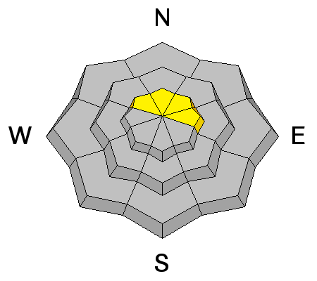
Today, the slowly increasing wind speeds will build new soft to medium hard drifts along ridgelines and in upper elevation terrain. This wind blown snow will stack up on top of a mix of facets, surface hoar and low-density snow - all perfect weak layers. These drifts could become quite sensitive by the end of the day, and even be triggered remotely. Identify them by the tell tale signs of cracking or collapsing, and their rounded, pillowy shapes. |
| type | aspect/elevation | characteristics |
|---|

|
|
LIKELIHOOD
 LIKELY
UNLIKELY
SIZE
 LARGE
SMALL
TREND
INCREASING DANGER
SAME
DECREASING DANGER
|
|
description
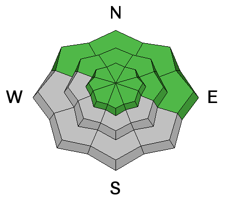
Long running loose snow sluffs can be triggered in steep, northerly terrain. Avoid getting caught and carried in one of theses, as you will likely hit rock and logs on your ride down slope. |
| type | aspect/elevation | characteristics |
|---|

|
|
LIKELIHOOD
 LIKELY
UNLIKELY
SIZE
 LARGE
SMALL
TREND
INCREASING DANGER
SAME
DECREASING DANGER
|
|
description
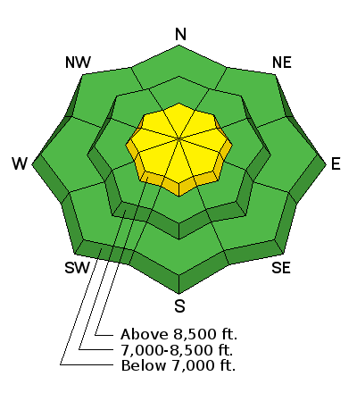
With current forecast, the dormant weak layers in the lower snow pack will become active - they are most widespread at elevations and aspects colored green above. A widespread avalanche cycle is possible Sunday through Monday, with avalanches breaking into the deeper weak layers being long running |
 |
weather Today, there will be mostly cloudy skies, with occasional light snow showers. Temperatures will remain in the twenties at 10,000’ and warm into the mid to upper 30s at 8000’. The southwesterly winds have bumped up a notch, with speeds at many stations in the 10 to 15 mph range. The highest peaks are reaching 20 to 25 mph averages, with gusts in the 30s. |
| general announcements Remember your information can save lives. If you see anything we should know about, please participate in the creation of our own community avalanche advisory by submitting snow and avalanche conditions. You can also call us at 801-524-5304, email by clicking HERE, or include #utavy in your tweet or Instagram. If you trigger an avalanche in the backcountry - especially if you are adjacent to a ski area – please call the following teams to alert them to the slide and whether anyone is missing or not. Rescue teams can be exposed to significant hazard when responding to avalanches, and do not want to do so when unneeded. Thanks. Salt Lake and Park City – Alta Central (801-742-2033), Canyons Resort Dispatch (435-615-3322) Snowbasin Resort Dispatch (801-620-1017), Powder Mountain Dispatch (801-745-3772 x 123). Sundance Dispatch (801-223-4150) EMAIL ADVISORY If you would like to get the daily advisory by email you will need to subscribe here. DAWN PATROL Hotline updated daily by 5-530am - 888-999-4019 option 8. Twitter Updates for your mobile phone - DETAILS UDOT canyon closures: LINK TO UDOT Utah Avalanche Center mobile app - Get your advisory on your iPhone along with great navigation and rescue tools. Wasatch Powderbird Guides Blog/Itinerary for the Day. Lost or Found something in the backcountry? - http://nolofo.com/ Discount lift tickets are now available at Backcountry.com with more resorts to come soon. Thanks to Ski Utah and the Utah Resorts. All proceeds go towards paying for Utah Avalanche Center avalanche and mountain weather advisories. To those skinning uphill at resorts: it is your responsibility to know the resort policy on uphill travel. You can see the uphill travel policy for each resort here. IMPORTANT: Before skinning or hiking at a resort under new snow conditions, check in with Ski Patrol. Resorts can restrict or cut off access if incompatible with control and grooming operations. Benefit the Utah Avalanche Center when you shop from Backcountry.com or REI: Click this link for Backcountry.com or this link to REI, shop, and they will donate a percent of your purchase price to the UAC. Both offer free shipping (with some conditions) so this costs you nothing! Benefit the Utah Avalanche Center when you buy or sell on ebay - set the Utah Avalanche Center as a favorite non-profit in your ebay account here and click on ebay gives when you buy or sell. You can choose to have your seller fees donated to the UAC, which doesn't cost you a penny. This information does not apply to developed ski areas or highways where avalanche control is normally done. This advisory is from the U.S.D.A. Forest Service, which is solely responsible for its content. This advisory describes general avalanche conditions and local variations always exist. |


_4.jpg)