| During the month of April, Mark Miller will donate $75 to the charity of your choice (5 to chose from, including the Utah Avalanche Center!) Mark Miller Subaru has raised over $300k in the previous 6 Do Good Feel Good events. More Info here |  |
| During the month of April, Mark Miller will donate $75 to the charity of your choice (5 to chose from, including the Utah Avalanche Center!) Mark Miller Subaru has raised over $300k in the previous 6 Do Good Feel Good events. More Info here | |
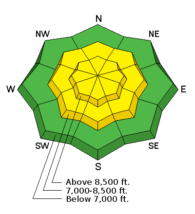
| Advisory: Ogden Area Mountains | Issued by Drew Hardesty for Tuesday - December 16, 2014 - 7:13am |
|---|

|
bottom line A MODERATE avalanche danger exists for overnight and developing wind drifts as well as loose snow/point-release avalanches. Shooting cracks on the slope from your weight will be an obvious clue of instability. It's possible that an initiated avalanche in northwest to easterly facing terrain may pull out an older wind drift sitting on faceted snow from last week.
|
 |
special announcement CANCELLED DUE TO ILLNESS - Fireside Chat at Black Diamond, Tuesday, December 16th, at 7pm. Tour the Slotterhouse: On Tuesday, Dec 16, at 6 pm Andrew McLean will do a slide show at the Petzl HQ about a recent trip to the Wrangell - St. Elias National Park and Preserve in AK to ski a spectacular collection of splitter couloirs and schlep around the world's most luxurious glacier camp, putting early British expeditions to shame. Details here. Discount lift tickets are in and for sale - ski a day at the resorts and benefit the Utah Avalanche Center. Tickets for Alta, Brighton, Deer Valley, Solitude, and Snowbasin, Snowbird, and Sundance are in and more tickets are expected shortly. |
 |
current conditions Apparently a fair number of you took Bruce's advice yesterday and called in sick. I hope you're feeling better today. Riding conditions are not bad in the now settled weekend 6-8" storm. Skies are overcast. Temps have warmed significantly in the past 24 hours - yesterday's 5am temps were in the mid-single digits - now they're in the mid to upper 20s. The southerly to southwesterly winds picked up in the afternoon, spiked for a couple hours around midnight and have dropped a touch, now blowing in the 20-30mph range with a few gusts near 40. |
| type | aspect/elevation | characteristics |
|---|

|
|
LIKELIHOOD
 LIKELY
UNLIKELY
SIZE
 LARGE
SMALL
TREND
 INCREASING DANGER
SAME
DECREASING DANGER
|
|
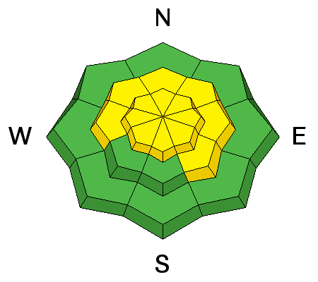
description
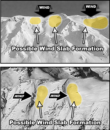
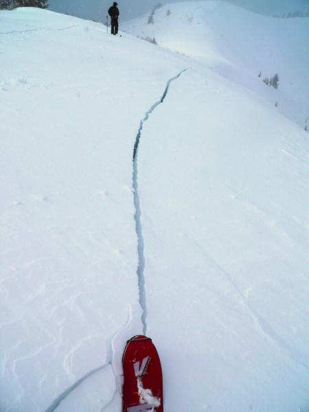
It doesn't take much wind to erode and drift the weekend's low density snow into garden-variety soft wind slabs - and they'll be scattered across the landscape at many locations at the mid and upper elevations. They'll be predominantly found on the northwest to north to northeast facing slopes, though cross-loaded beyond sub-ridges into gullies and other open terrain. Remember that through what we call "terrain channeling", the topography - through forcing, constriction and other factors - can lead to counter-intuitive areas of wind loading independent of the "free-air" prevailing winds from the south and southwest. In many ways, it's not so unlike a river - with downstream current, eddies, boils, and standing waves. Hot tip - shooting cracks - as seen below (White photo) will be a key sign of instability.
But here's the good news - the wind drifts should be fairly recognizable - smooth and rounded, and sensitive to provocation. Test slopes, ski and slope cuts, previous tracks, (tests and obs) are all good indicators of conditions. Click on the 'i' next to the Wind Slab icon for more info and travel advice. |
| type | aspect/elevation | characteristics |
|---|

|
|
LIKELIHOOD
 LIKELY
UNLIKELY
SIZE
LARGE
SMALL
TREND
INCREASING DANGER
SAME
DECREASING DANGER
|
|
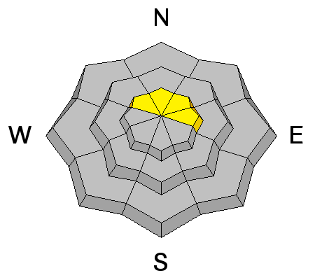
description
Here's the bad news. If the new wind drifts are manageable, what lies beneath is not. Last Thursday/Friday's strong southerly winds littered the landscape with pockets of land-mine hard drifts. To be sure, they're pockety, fairly shallow, and mostly settled...and yet are quite the opposite from the loose snow and soft wind slabs on top of them in that in general, tests and observations tend to be unreliable. Previous tracks - unreliable. Slope cuts and cornice drops? Unreliable. And they tend to allow you to get well onto them before breaking out above you. Click on the 'i' next to the Persistent Slab icon for more info and travel advice. |
| type | aspect/elevation | characteristics |
|---|

|
|
LIKELIHOOD
 LIKELY
UNLIKELY
SIZE
 LARGE
SMALL
TREND
 INCREASING DANGER
SAME
DECREASING DANGER
|
|
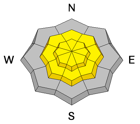
description
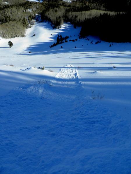
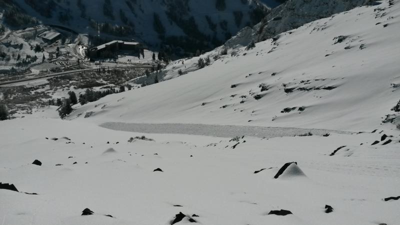
Sluffing of the slow will continue on all aspects of the mid and upper elevations and may pack a punch in steep, sustained terrain. (Photos - White, Rice)
|
 |
weather A number of weak systems will move through over the next several days though it shouldn't amount to much. We'll have mostly cloudy to overcast skies, southwesterly winds blowing 20-25mph, and temps in the mid 20s at 10,000', the upper 20s to near 30 at 8000'. We may see a trace or two of snow today, particularly in the northern mountains. |
| general announcements
Remember your information can save lives. If you see anything we should know about, please participate in the creation of our own community avalanche advisory by submitting snow and avalanche conditions. You can also call us at 801-524-5304, email by clicking HERE, or include #utavy in your tweet or Instagram. If you trigger an avalanche in the backcountry - especially if you are adjacent to a ski area – please call the following teams to alert them to the slide and whether anyone is missing or not. Rescue teams can be exposed to significant hazard when responding to avalanches, and do not want to do so when unneeded. Thanks. Salt Lake and Park City – Alta Central (801-742-2033), Canyons Resort Dispatch (435-615-3322) Snowbasin Resort Dispatch (801-620-1017), Powder Mountain Dispatch (801-745-3772 x 123). Sundance Dispatch (801-223-4150) EMAIL ADVISORY If you would like to get the daily advisory by email you will need to subscribe here. DAWN PATROL Hotline updated daily by 5-530am - 888-999-4019 option 8. Twitter Updates for your mobile phone - DETAILS UDOT canyon closures: LINK TO UDOT Utah Avalanche Center mobile app - Get your advisory on your iPhone along with great navigation and rescue tools. Wasatch Powderbird Guides Blog/Itinerary for the Day. Lost or Found something in the backcountry? - http://nolofo.com/ Discount lift tickets are now available at Backcountry.com with more resorts to come soon. Thanks to Ski Utah and the Utah Resorts. All proceeds go towards paying for Utah Avalanche Center avalanche and mountain weather advisories. To those skinning uphill at resorts: it is your responsibility to know the resort policy on uphill travel. You can see the uphill travel policy for each resort here. IMPORTANT: Before skinning or hiking at a resort under new snow conditions, check in with Ski Patrol. Resorts can restrict or cut off access if incompatible with control and grooming operations. Benefit the Utah Avalanche Center when you shop from Backcountry.com or REI: Click this link for Backcountry.com or this link to REI, shop, and they will donate a percent of your purchase price to the UAC. Both offer free shipping (with some conditions) so this costs you nothing! Benefit the Utah Avalanche Center when you buy or sell on ebay - set the Utah Avalanche Center as a favorite non-profit in your ebay account here and click on ebay gives when you buy or sell. You can choose to have your seller fees donated to the UAC, which doesn't cost you a penny. This information does not apply to developed ski areas or highways where avalanche control is normally done. This advisory is from the U.S.D.A. Forest Service, which is solely responsible for its content. This advisory describes general avalanche conditions and local variations always exist. |


_4.jpg)