| During the month of April, Mark Miller will donate $75 to the charity of your choice (5 to chose from, including the Utah Avalanche Center!) Mark Miller Subaru has raised over $300k in the previous 6 Do Good Feel Good events. More Info here |  |
| During the month of April, Mark Miller will donate $75 to the charity of your choice (5 to chose from, including the Utah Avalanche Center!) Mark Miller Subaru has raised over $300k in the previous 6 Do Good Feel Good events. More Info here | |
| Advisory: Ogden Area Mountains | Issued by Brett Kobernik for Thursday - December 4, 2014 - 7:13am |
|---|

|
bottom line Most terrain has a LOW avalanche danger. A MODERATE danger exists in the highest northwest through east facing terrain where you may find some sensitive fresh wind drifts or the chance for triggering a persistent slab avalanche. Continue to evaluate the upper elevation terrain and snowpack carefully.
|
 |
current conditions The mountains received a trace to a couple of inches of high density snow on Wednesday. Rain/snow lines were around 8000 feet. The new snow was drifting a bit along the more exposed locations. Overnight, temperatures remain mild with most stations coming in around freezing and only into the mid 20s along the 10000 foot locations. Winds bumped up in speed slightly but still only in the moderate range from a west southwest direction. There's been a big change to the snowpack with the recent warm temperatures. It is basically wet from the ground to the surface on all aspects up to around 9000 feet. During field work on Wednesday in the Salt Lake region, we found the basal facets moist and non-reactive in tests at 9700 feet. Others found similar conditions but were able to get full propagation after being quite forceful. Below are a couple of good observations describing the change that's occurring. While I can't say much for the riding conditions, at least the basal facets are going through a change for the better. The caveat is we will want to continue to watch these facets in the highest terrain. Continued warm temperatures forecast for about a week to come should encourage further settlement and rounding of these weak grains.
|
| type | aspect/elevation | characteristics |
|---|

|
|
LIKELIHOOD
 LIKELY
UNLIKELY
SIZE
 LARGE
SMALL
TREND
 INCREASING DANGER
SAME
DECREASING DANGER
|
|
description
If you're up along the highest ridgelines, you may find some fresh drifts that might crack out. These won't pose much threat unless you get taken off guard in exposed terrain where you may get flushed over rocks or through trees. |
 |
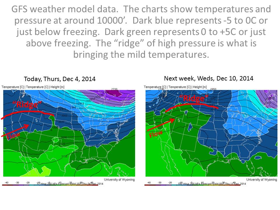
weather We'll see clouds and the chance for some snow flurries today without much accumulation expected. The rain/snow line will once again be quite high (near 8000') with continued mild temperatures. There's a break on Friday then another weak disturbance into Saturday will again bring some minor snow accumulations and continued mild temperatures. Warm temperatures will continue and the GFS weather model predicts they'll get even warmer in the middle of next week. |


_4.jpg)