| During the month of April, Mark Miller will donate $75 to the charity of your choice (5 to chose from, including the Utah Avalanche Center!) Mark Miller Subaru has raised over $300k in the previous 6 Do Good Feel Good events. More Info here |  |
| During the month of April, Mark Miller will donate $75 to the charity of your choice (5 to chose from, including the Utah Avalanche Center!) Mark Miller Subaru has raised over $300k in the previous 6 Do Good Feel Good events. More Info here | |
| Advisory: Ogden Area Mountains | Issued by Bruce Tremper for Friday - November 28, 2014 - 7:01am |
|---|

|
bottom line Continue to be suspicious of:
|
 |
current conditions Snow surface has the consistency of the stiff mashed potatoes at our Thanksgiving dinner yesterday--dry and creamy up high mixed with wind damage with damp to mushy mashed potatoes down low. It's warm with near freezing temperatures overnight that will rise into the mid 40's during the day. |
 |
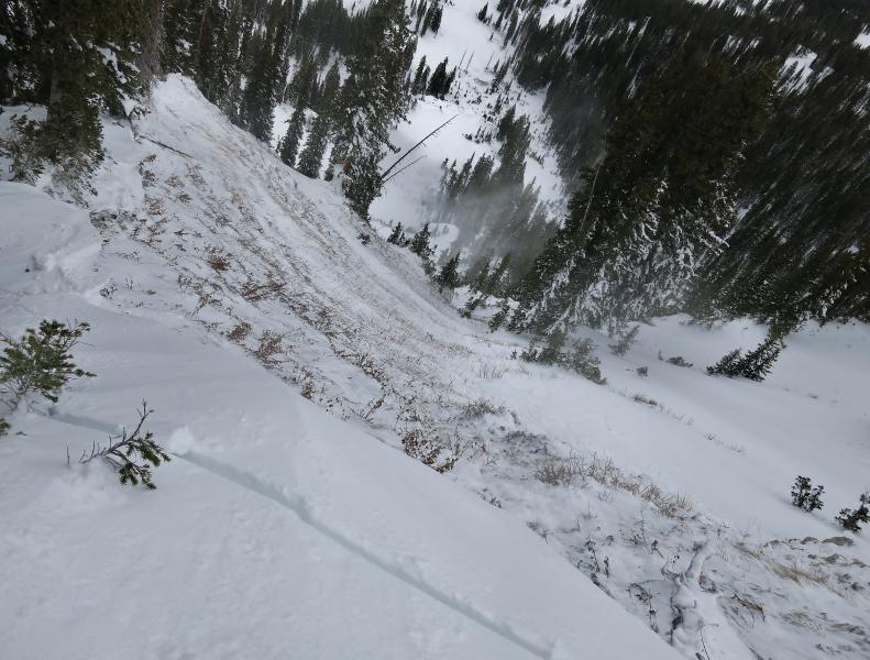
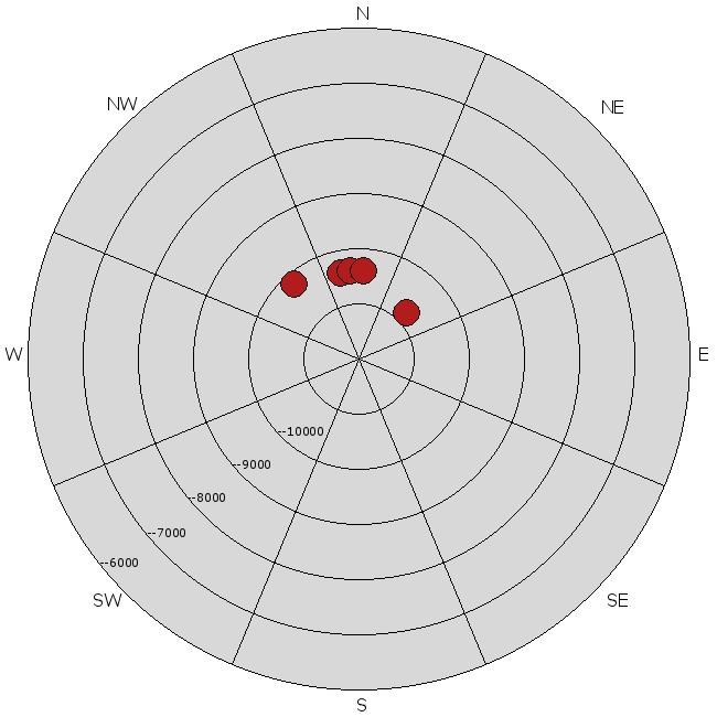
recent activity There was a very close call yesterday when a backcountry skier was ascending Pioneer Ridge west of Brighton and did a slope cut on a steep, north facing slope. He triggered a deep, wide avalanche that fractured out all the snow to the ground. Luckily, he was not carried down because it would have been difficult to survive the rocky, steep ride. More details HERE. Looking down the slide path with the dust cloud visible below. It would have been a nasty ride. Here are other avalanches from the past few days along with their plots on an aspect-elevation diagram:
November 26 avalanches by aspect and elevation
|
| type | aspect/elevation | characteristics |
|---|

|
|
LIKELIHOOD
 LIKELY
UNLIKELY
SIZE
 LARGE
SMALL
TREND
 INCREASING DANGER
SAME
DECREASING DANGER
|
|
description
The Ogden area mountains does not have as much faceted snow near the ground as the higher mountains near Salt Lake and Provo. But there may be some upper elevation areas where you can find similar conditions, so here is the information for Salt Lake and Provo: This avalanche character is called Persistent Slab because, well, it's persistent. The weak layer of depth hoar near the ground takes its sweet time to gain strength and it's still quite touchy after being loaded up with 3 feet of snow last weekend then loaded with more dense snow and wind on Tuesday. (Click the "I" button next to the icon for more information.) I'm quite frightened by this setup because as the slab gains strength, it becomes progressively harder to trigger, which can entice people to pull the tail on this cranky, old cat and there's certain to be someone today or through the weekend that will have another close call or worse. These avalanches are more dangerous than usual because with this thin snowpack, even small avalanches will bounce you through rocks, logs and trees on the way down. Remember avalanche danger is a combination of both probability and consequences. Here is a short video of what we found yesterday for a good example of the touchy nature of the snowpack: http://youtu.be/b7eOipvrJtM
|
| type | aspect/elevation | characteristics |
|---|

|
|
LIKELIHOOD
 LIKELY
UNLIKELY
SIZE
 LARGE
SMALL
TREND
 INCREASING DANGER
SAME
DECREASING DANGER
|
|
description
Temperatures will warm even more than the balmy conditions yesterday complete with some sun this afternoon. We may see some additional wet sluffs and rollerballs especially on low elevation, steep terrain. |
 |
weather We'll have another mild day with ridge top temperatures near freezing this morning rising to the 40's this afternoon. High clouds this morning should turn to mostly sunny this afternoon. Ridge top winds should blow stronger this afternoon 15-25 from the southwest. It should be windy again on Saturday but with high clouds. For the extended forecast, we will have a boundary between warm and cold air nick northern Utah on Sunday, which should give us a couple inches of snow, with more snow in the Logan area mountains. Then it looks like a bit stronger system for about Wednesday. |
| general announcements Remember your information can save lives. If you see anything we should know about, please participate in the creation of our own community avalanche advisory by submitting snow and avalanche conditions. You can also call us at 801-524-5304, email by clicking HERE, or include #utavy in your tweet or Instagram. If you trigger an avalanche in the backcountry - especially if you are adjacent to a ski area – please call the following teams to alert them to the slide and whether anyone is missing or not. Rescue teams can be exposed to significant hazard when responding to avalanches, and do not want to do so when unneeded. Thanks. Salt Lake and Park City – Alta Central (801-742-2033), Canyons Resort Dispatch (435-615-3322) Snowbasin Resort Dispatch (801-620-1017), Powder Mountain Dispatch (801-745-3772 x 123). Sundance Dispatch (801-223-4150) EMAIL ADVISORY If you would like to get the daily advisory by email you will need to subscribe here. DAWN PATROL Hotline updated daily by 5-530am - 888-999-4019 option 8. Twitter Updates for your mobile phone - DETAILS UDOT canyon closures: LINK TO UDOT Utah Avalanche Center mobile app - Get your advisory on your iPhone along with great navigation and rescue tools. Wasatch Powderbird Guides Blog/Itinerary for the Day. Lost or Found something in the backcountry? - http://nolofo.com/ Discount lift tickets will soon be available at Backcountry.com - Thanks to Ski Utah and the Utah Resorts. All proceeds go towards paying for Utah Avalanche Center avalanche and mountain weather advisories. To those skinning uphill at resorts: it is your responsibility to know the resort policy on uphill travel. You can see the uphill travel policy for each resort here. IMPORTANT: Before skinning or hiking at a resort under new snow conditions, check in with Ski Patrol. Resorts can restrict or cut off access if incompatible with control and grooming operations. Benefit the Utah Avalanche Center when you shop from Backcountry.com or REI: Click this link for Backcountry.com or this link to REI, shop, and they will donate a percent of your purchase price to the UAC. Both offer free shipping (with some conditions) so this costs you nothing! Benefit the Utah Avalanche Center when you buy or sell on ebay - set the Utah Avalanche Center as a favorite non-profit in your ebay account here and click on ebay gives when you buy or sell. You can choose to have your seller fees donated to the UAC, which doesn't cost you a penny. This information does not apply to developed ski areas or highways where avalanche control is normally done. This advisory is from the U.S.D.A. Forest Service, which is solely responsible for its content. This advisory describes general avalanche conditions and local variations always exist. |


_4.jpg)