
| During the month of April, Mark Miller will donate $75 to the charity of your choice (5 to chose from, including the Utah Avalanche Center!) Mark Miller Subaru has raised over $300k in the previous 6 Do Good Feel Good events. More Info here |  |
| During the month of April, Mark Miller will donate $75 to the charity of your choice (5 to chose from, including the Utah Avalanche Center!) Mark Miller Subaru has raised over $300k in the previous 6 Do Good Feel Good events. More Info here | |
| Advisory: Ogden Area Mountains | Issued by Brett Kobernik for Wednesday - November 26, 2014 - 7:44am |
|---|

|
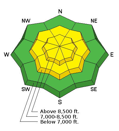
bottom line The avalanche danger is MODERATE in the upper elevation northwest through east facing slopes that are steeper than about 35 degrees above around 9500 feet. Watch for new wind drifts and sensitive cornices along upper elevation lee slopes. Also keep in mind the sunny slopes and lower elevations will become wet and may produce loose snow slides.
|
 |
current conditions A trace to 2 inches of snow fell on Tuesday and last night with warming temperatures now into the mid to upper 20s. There was some rain below 6000 or 7000 feet with the snow becoming damp. Rollerballs were noted in the lowest terrain. Winds were bearable during the day yesterday but were increasing late in the day and are still blowing from the west with gusts in the 60s and 70s along the highest ridges and gusts in the low 20s along the mid elevation ridges. |
 |
recent activity There were no new avalanches reported from the backcountry on Tuesday. Collapsing has decreased but still noted in observations. Avalanche mitigation at the ski resorts from the Park City Ridgeline through the Cottonwoods continued to produce large avalanches with explosives on Tuesday, some releasing remote to the shot. |
| type | aspect/elevation | characteristics |
|---|

|
|
LIKELIHOOD
 LIKELY
UNLIKELY
SIZE
 LARGE
SMALL
TREND
 INCREASING DANGER
SAME
DECREASING DANGER
|
|
description
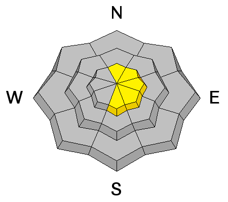
The winds have drifted some snow and you'll find fresh drifts out there today that may be sensitive to the weight of a person. Keep an eye on the fresh cornices as well. Both of these issues are only a secondary concern to the persistent slab issue but don't disregard them. "Pillowy" looking drifts, scalloped features and hollow sounds underfoot are all indicators of recent wind drifting. |
| type | aspect/elevation | characteristics |
|---|

|
|
LIKELIHOOD
 LIKELY
UNLIKELY
SIZE
LARGE
SMALL
TREND
INCREASING DANGER
SAME
DECREASING DANGER
|
|
description
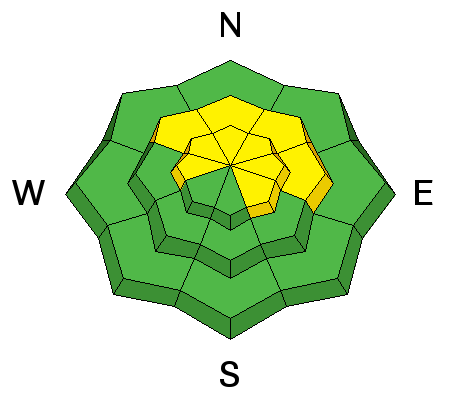
The persistent slab issue is not as pronounced in the Ogden area as it is in the Salt Lake region. There was not that much snow in early November to facet and become weak. So, the now buried weak snow is not a huge issue at this time but it's still worth a mention and worth looking into if you're getting into the backcountry. |
| type | aspect/elevation | characteristics |
|---|

|
|
LIKELIHOOD
 LIKELY
UNLIKELY
SIZE
LARGE
SMALL
TREND
 INCREASING DANGER
SAME
DECREASING DANGER
|
|
description
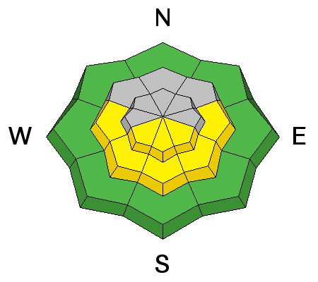
Probably an outlier for today but worth a mention is the chance for a few wet "dribblers" on the sunny slopes and lower elevations. Sun and warm temperatures might produce a few wet loose snow slides. |
 |
weather We'll have clearing skies today with warm temperatures and windy conditions still this morning. Winds should slowly decrease as the day goes on. Ridgetop temperatures will get into the low 30s. The ridge of high pressure responsible for this warming trend will be around through the rest of the week with a small storm that we're keeping an eye on for Sunday. |
| general announcements Remember your information can save lives. If you see anything we should know about, please participate in the creation of our own community avalanche advisory by submitting snow and avalanche conditions. You can also call us at 801-524-5304, email by clicking HERE, or include #utavy in your tweet or Instagram. If you trigger an avalanche in the backcountry - especially if you are adjacent to a ski area – please call the following teams to alert them to the slide and whether anyone is missing or not. Rescue teams can be exposed to significant hazard when responding to avalanches, and do not want to do so when unneeded. Thanks. Salt Lake and Park City – Alta Central (801-742-2033), Canyons Resort Dispatch (435-615-3322) Snowbasin Resort Dispatch (801-620-1017), Powder Mountain Dispatch (801-745-3772 x 123). Sundance Dispatch (801-223-4150) EMAIL ADVISORY If you would like to get the daily advisory by email you will need to subscribe here. DAWN PATROL Hotline updated daily by 5-530am - 888-999-4019 option 8. Twitter Updates for your mobile phone - DETAILS UDOT canyon closures: LINK TO UDOT Utah Avalanche Center mobile app - Get your advisory on your iPhone along with great navigation and rescue tools. Wasatch Powderbird Guides Blog/Itinerary for the Day. Lost or Found something in the backcountry? - http://nolofo.com/ Discount lift tickets will soon be available at Backcountry.com - Thanks to Ski Utah and the Utah Resorts. All proceeds go towards paying for Utah Avalanche Center avalanche and mountain weather advisories. To those skinning uphill at resorts: it is your responsibility to know the resort policy on uphill travel. You can see the uphill travel policy for each resort here. IMPORTANT: Before skinning or hiking at a resort under new snow conditions, check in with Ski Patrol. Resorts can restrict or cut off access if incompatible with control and grooming operations. Benefit the Utah Avalanche Center when you shop from Backcountry.com or REI: Click this link for Backcountry.com or this link to REI, shop, and they will donate a percent of your purchase price to the UAC. Both offer free shipping (with some conditions) so this costs you nothing! Benefit the Utah Avalanche Center when you buy or sell on ebay - set the Utah Avalanche Center as a favorite non-profit in your ebay account here and click on ebay gives when you buy or sell. You can choose to have your seller fees donated to the UAC, which doesn't cost you a penny. This information does not apply to developed ski areas or highways where avalanche control is normally done. This advisory is from the U.S.D.A. Forest Service, which is solely responsible for its content. This advisory describes general avalanche conditions and local variations always exist. |


_4.jpg)