| During the month of April, Mark Miller will donate $75 to the charity of your choice (5 to chose from, including the Utah Avalanche Center!) Mark Miller Subaru has raised over $300k in the previous 6 Do Good Feel Good events. More Info here |  |
| During the month of April, Mark Miller will donate $75 to the charity of your choice (5 to chose from, including the Utah Avalanche Center!) Mark Miller Subaru has raised over $300k in the previous 6 Do Good Feel Good events. More Info here | |
| Advisory: Ogden Area Mountains | Issued by Drew Hardesty for Tuesday - November 25, 2014 - 7:13am |
|---|

|
bottom line The winds will be a game changer. A CONSIDERABLE danger exists on all wind drifted slopes at the mid and upper elevations. I expect both natural and human triggered avalanches today. They'll be most pronounced on north through east through south facing slopes with any triggered slide potentially stepping to the ground 3-4' deep in suspect terrain. Avalanches may still be triggered remotely, even from perceived safe terrain beneath the slope. The danger scale says "Experts Only" for Considerable danger - and all the experts I know aren't yet sticking their necks out in steep terrain.
|
 |
current conditions Impressive storm totals indeed. By the time it was all said and done in the mid to late morning, the Cottonwoods picked up 30-36", the Park City mountains 18-24", the Ogden and Provo mountains 10-14". We needed that - though today's warm front will be like throwing a wet blanket on top of it all. Currently, temps are in the teens with westerly winds already blowing in the 40mph range with gusts near 60 along the high ridgelines. Mid elevation stations register winds gusting to 40. They've only just begun. |
 |
recent activity Some collapsing was noted in the mid-elevations yesterday but there isn't the same load on the buried weak layers as found further south in the Cottonwoods. That may change today with the wind drifts. In the central Wasatch - Fewer people were out and about yesterday, though the mountain resorts more than made up for that - avalanche control teams initiated many large slides with both ski and slope cuts and explosives. Most were on the northern half of the compass at the mid and upper elevations, with some pulling out 3-5'. Others pulled out remotely from the explosive shot placement. In the backcountry, one natural slab avalanche likely released sometime early Monday in the Meadow Chutes of Silver Fork, a steep northeast facing rollover on the slope affectionately known as 'El Rollo'. Just across the street in Big Cottonwood, a skier from the ridgeline 150' away remotely triggered a 2.5' deep and 200' wide avalanche in Scott's bowl, a steep east to northeast facing slope on the Park City ridgeline. (Links take you to Utah Avalanche Center board member Steve Achelis's Wasatch Backcountry Skiing map- tear and weather resistant paper map also available). Scott's Bowl avalanche pic (Young) below -
|
| type | aspect/elevation | characteristics |
|---|

|
|
LIKELIHOOD
 LIKELY
UNLIKELY
SIZE
 LARGE
SMALL
TREND
 INCREASING DANGER
SAME
DECREASING DANGER
|
|
description
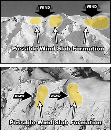
Let's hope that the storm totals of 20-30" don't end up in the Heber Valley after searing winds in the forecasted 40-50mph range with gusts near 80. Snow that doesn't make to Woodruff and Randolph will be found on the lee sides of ridgelines, cross-loaded in gullies, beyond rocky outcrops and into other deceleration zones. I expect them to be initially sensitive, then increasingly thick and stubborn and more dangerous..and not limited to the exposed upper elevations. Collapsing and cracking are sure signs of instability - and take note that wind drifts with these speeds may be well down the slope and in unusual terrain. Click on the 'i' next to the Wind Slab icon for more details....
|
| type | aspect/elevation | characteristics |
|---|

|
|
LIKELIHOOD
 LIKELY
UNLIKELY
SIZE
LARGE
SMALL
TREND
INCREASING DANGER
SAME
DECREASING DANGER
|
|
description
With buried weaknesses from the storm two weekends ago, we may see active persistent slabs today with remotely triggered slides possible. It's what we loosely call "collapse failure" or - if you're keen to have others on the lift, skin-track, or car roll their eyes, "mixed-mode anti-crack model for fracture mechanics". In this way, it's possible from where you're standing to collapse the slab onto the facets below, sending a "shock wave" through the slab and have it avalanche once it finds a suitably steep slope. For more info, click the 'i' next to the Persistent Slab icon.
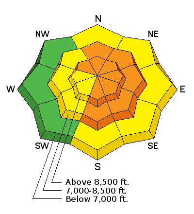
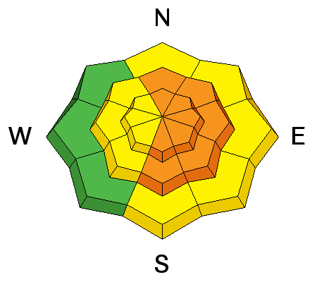
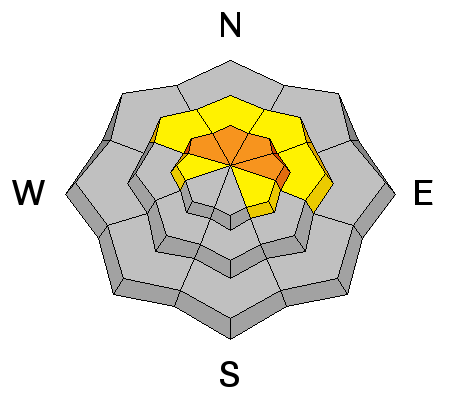
The avalanche activity roses below represent the reported backcountry avalanches from the most recent avalanche cycle on the left....the two avalanche cycles combined on the right. It should be noted that the mountain resorts have also had significant activity on east and northwest facing slopes as well.
|
 |
weather Rising temps (and a rising rain/snow line), a few wet soggy inches, periods of riming, and strong winds are all on board for this warm front today. We can expect 2-4" in the central Wasatch, with perhaps a couple more in the Ogden and Logan area mountains. The rain/snow line may rise toward 7500' or so by the end of the day as temps warm to near 30F by tonight/early tomorrow. The west to northwest steam locomotive will have hourly wind speeds in the 40-50mph range with gusts to near 80. The most exposed ridgelines and peaks may see hourly averages in the 60-70mph range with gusts to 80/90. The ridge of high pressure just to the west will move overhead for midweek and followed by some weak systems through the weekend. The weather models hint at a more significant storm system slated for the first days of December. |
| general announcements
Remember your information can save lives. If you see anything we should know about, please participate in the creation of our own community avalanche advisory by submitting snow and avalanche conditions. You can also call us at 801-524-5304, email by clicking HERE, or include #utavy in your tweet or Instagram. If you trigger an avalanche in the backcountry - especially if you are adjacent to a ski area – please call the following teams to alert them to the slide and whether anyone is missing or not. Rescue teams can be exposed to significant hazard when responding to avalanches, and do not want to do so when unneeded. Thanks. Salt Lake and Park City – Alta Central (801-742-2033), Canyons Resort Dispatch (435-615-3322) Snowbasin Resort Dispatch (801-620-1017), Powder Mountain Dispatch (801-745-3772 x 123). Sundance Dispatch (801-223-4150) EMAIL ADVISORY If you would like to get the daily advisory by email you will need to subscribe here. DAWN PATROL Hotline updated daily by 5-530am - 888-999-4019 option 8. Twitter Updates for your mobile phone - DETAILS UDOT canyon closures: LINK TO UDOT Utah Avalanche Center mobile app - Get your advisory on your iPhone along with great navigation and rescue tools. Wasatch Powderbird Guides Blog/Itinerary for the Day. Lost or Found something in the backcountry? - http://nolofo.com/ Discount lift tickets will soon be available at Backcountry.com - Thanks to Ski Utah and the Utah Resorts. All proceeds go towards paying for Utah Avalanche Center avalanche and mountain weather advisories. To those skinning uphill at resorts: it is your responsibility to know the resort policy on uphill travel. You can see the uphill travel policy for each resort here. IMPORTANT: Before skinning or hiking at a resort under new snow conditions, check in with Ski Patrol. Resorts can restrict or cut off access if incompatible with control and grooming operations. Benefit the Utah Avalanche Center when you shop from Backcountry.com or REI: Click this link for Backcountry.com or this link to REI, shop, and they will donate a percent of your purchase price to the UAC. Both offer free shipping (with some conditions) so this costs you nothing! Benefit the Utah Avalanche Center when you buy or sell on ebay - set the Utah Avalanche Center as a favorite non-profit in your ebay account here and click on ebay gives when you buy or sell. You can choose to have your seller fees donated to the UAC, which doesn't cost you a penny. This information does not apply to developed ski areas or highways where avalanche control is normally done. This advisory is from the U.S.D.A. Forest Service, which is solely responsible for its content. This advisory describes general avalanche conditions and local variations always exist. |


_4.jpg)
.JPG)