
| During the month of April, Mark Miller will donate $75 to the charity of your choice (5 to chose from, including the Utah Avalanche Center!) Mark Miller Subaru has raised over $300k in the previous 6 Do Good Feel Good events. More Info here |  |
| During the month of April, Mark Miller will donate $75 to the charity of your choice (5 to chose from, including the Utah Avalanche Center!) Mark Miller Subaru has raised over $300k in the previous 6 Do Good Feel Good events. More Info here | |
| Advisory: Ogden Area Mountains | Issued by Evelyn Lees for Sunday - November 23, 2014 - 7:14am |
|---|


|
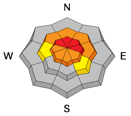
bottom line The avalanche danger is HIGH on upper elevation slopes facing northwest through north through southeast, where the snow is landing on the old, weak sugary facets. A CONSIDERABLE avalanche danger exists on steep mid elevation slopes, facing northwest through north through east. AVOID travel on and below these slopes, as it is possible to trigger slides remotely from a distance and from below. Taking a ride in an early season avalanche is particularly dangerous, as the chance of hitting a rock is high. If you do choose to head out today, choose slopes gentler than 30 degrees in steepness with nothing above.
|
 |
avalanche warning The Avalanche Warning for all the mountains of northern Utah has been continued. Dangerous avalanche conditions exist at the mid and upper elevations, with both natural and human triggered slides likely. This warning does not include ski areas or highways where avalanche control is normally done. |
 |
current conditions Light to moderate snow is falling this morning, as another piece of the storm drops south along the Wasatch mountains.
|
 |
recent activity Some natural activity was reported from the Cottonwoods overnight, and a few small wind pockets popped out yesterday on steep low elevation terrain in the Park City mountains. There were no observations from the backcountry yesterday. |
| type | aspect/elevation | characteristics |
|---|

|
|
LIKELIHOOD
 LIKELY
UNLIKELY
SIZE
 LARGE
SMALL
TREND
 INCREASING DANGER
SAME
DECREASING DANGER
|
|
description
The winds tipped the balance overnight, helping overload the slopes with old, sugary snow on the ground. Prime terrain for avalanches toady are upper elevation slopes, facing west through north through southeast, especially where wind drifted. The wind drifted snow will be both along the ridgelines and mid slope, piled up along sub ridges, break overs, and the sides of gullies. Many shadier mid elevation slopes also had weak, sugary snow sitting on the ground, and it will be possible to trigger avalanches on steep slopes in this terrain too. Avalanches today can be triggered remotely from a distance – avoid travel below and adjacent to steep slopes. |
| type | aspect/elevation | characteristics |
|---|

|
|
LIKELIHOOD
LIKELY
UNLIKELY
SIZE
 LARGE
SMALL
TREND
 INCREASING DANGER
SAME
DECREASING DANGER
|
|
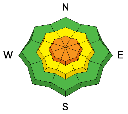
description
You will find wind drifts scattered all over – on a variety of elevations and aspects. You will be most likely to trigger a drift where it is sitting on sugary old snow, but drifts should be avoided on all steep slopes. |
 |
weather Light to moderate snowfall will continue for a few more hours this morning, before there is a significant break in the snow through this evening. Skies will remain mostly cloudy today, and temperatures won’t warm much – remaining in the teens and low 20s. The northwesterly winds are decreasing, and should be in the 10 to 20 mph range at most locations by this afternoon, with the highest peaks averaging to 30 mph, with gusts to 50. One last piece of the storm should arrive after midnight, bringing an additional 4 to 8” of snow by Monday afternoon. The beginning of next week looks quiet. |
| general announcements Remember your information can save lives. If you see anything we should know about, please participate in the creation of our own community avalanche advisory by submitting snow and avalanche conditions. You can also call us at 801-524-5304, email by clicking HERE, or include #utavy in your tweet or Instagram. If you trigger an avalanche in the backcountry - especially if you are adjacent to a ski area – please call the following teams to alert them to the slide and whether anyone is missing or not. Rescue teams can be exposed to significant hazard when responding to avalanches, and do not want to do so when unneeded. Thanks. Salt Lake and Park City – Alta Central (801-742-2033), Canyons Resort Dispatch (435-615-3322) Snowbasin Resort Dispatch (801-620-1017), Powder Mountain Dispatch (801-745-3772 x 123). Sundance Dispatch (801-223-4150) EMAIL ADVISORY If you would like to get the daily advisory by email you will need to subscribe here. DAWN PATROL Hotline updated daily by 5-530am - 888-999-4019 option 8. Twitter Updates for your mobile phone - DETAILS UDOT canyon closures: LINK TO UDOT Utah Avalanche Center mobile app - Get your advisory on your iPhone along with great navigation and rescue tools. Wasatch Powderbird Guides Blog/Itinerary for the Day. Lost or Found something in the backcountry? - http://nolofo.com/ Discount lift tickets will soon be available at Backcountry.com - Thanks to Ski Utah and the Utah Resorts. All proceeds go towards paying for Utah Avalanche Center avalanche and mountain weather advisories. To those skinning uphill at resorts: it is your responsibility to know the resort policy on uphill travel. You can see the uphill travel policy for each resort here. IMPORTANT: Before skinning or hiking at a resort under new snow conditions, check in with Ski Patrol. Resorts can restrict or cut off access if incompatible with control and grooming operations. Benefit the Utah Avalanche Center when you shop from Backcountry.com or REI: Click this link for Backcountry.com or this link to REI, shop, and they will donate a percent of your purchase price to the UAC. Both offer free shipping (with some conditions) so this costs you nothing! Benefit the Utah Avalanche Center when you buy or sell on ebay - set the Utah Avalanche Center as a favorite non-profit in your ebay account here and click on ebay gives when you buy or sell. You can choose to have your seller fees donated to the UAC, which doesn't cost you a penny. This information does not apply to developed ski areas or highways where avalanche control is normally done. This advisory is from the U.S.D.A. Forest Service, which is solely responsible for its content. This advisory describes general avalanche conditions and local variations always exist. |


_4.jpg)