| During the month of April, Mark Miller will donate $75 to the charity of your choice (5 to chose from, including the Utah Avalanche Center!) Mark Miller Subaru has raised over $300k in the previous 6 Do Good Feel Good events. More Info here |  |
| During the month of April, Mark Miller will donate $75 to the charity of your choice (5 to chose from, including the Utah Avalanche Center!) Mark Miller Subaru has raised over $300k in the previous 6 Do Good Feel Good events. More Info here | |
| Advisory: Ogden Area Mountains | Issued by Evelyn Lees for Saturday - November 22, 2014 - 7:25am |
|---|


|
bottom line The avalanche danger will be increasing over the next 24 hours – and the rose represents the avalanche danger for late this afternoon and tonight.
|
 |
avalanche warning An Avalanche Warning has been issued for 3 pm this afternoon for all the mountains of northern Utah. Dangerous avalanche conditions will develop this late this afternoon and overnight as strong winds and heavy snow overload the preexisting weak snow pack. This Avalanche Warning is from 3 pm this afternoon through Monday. |
 |
special announcement While open for the season, Solitude is closed to uphill traffic. Always check with ski patrol or the main office before skiing uphill at a resort. |
 |
current conditions This morning, the mountain temperatures are in the upper 20s to mid 30s in the Ogden area mountains. The southwesterly winds have ramped up in the past few hours – speeds across the high peaks are averaging 30s and 40s, gusting to 60 mph.. Wind speeds at the mid elevations are averaging 15 to 20 mph. The overall snowpack is very shallow – only 6 to 10” on the ground in the Odgen area mountains. |
 |
recent activity No new avalanches reported yesterday. |
| type | aspect/elevation | characteristics |
|---|

|
|
LIKELIHOOD
 LIKELY
UNLIKELY
SIZE
 LARGE
SMALL
TREND
 INCREASING DANGER
SAME
DECREASING DANGER
|
|
description
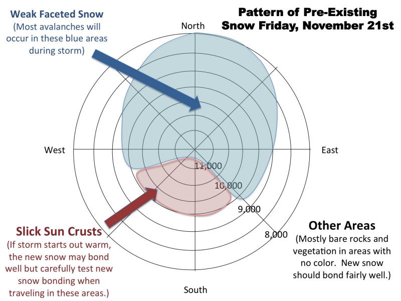
Over the past week, most of the shallow snow pack has become faceted, weak and sugary. This weak snow exists on upper elevation slopes facing west through north through east, and many of the shadier mid elevation slopes. As snow falls today and tonight, it will become possible to trigger avalanches on steep slopes and remotely from a distance. As the snow piles up, avoid slopes steeper than about 30 degrees, and travel below steep slopes. Here is a repost of Bruce's great graphic from yesterday showing the pattern of pre-existing snow. This is for the Cottonwoods, but the Ogden area coverage is similar, just shallower.
|
| type | aspect/elevation | characteristics |
|---|

|
|
LIKELIHOOD
LIKELY
UNLIKELY
SIZE
LARGE
SMALL
TREND
INCREASING DANGER
SAME
DECREASING DANGER
|
|
description
Sensitive new wind drifts will be developing today through tonight. You will be most likely to trigger a drift where it is sitting on sugary old snow, but drifts should be avoided on all steep slopes. |
 |
weather It will be warm and blustery this morning, with occasional light snow. The moderate southwesterly winds will gradually increase into the afternoon, and high temperatures will be in the mid to upper 30s. The cold front should arrive around 4-5 pm tonight. The strongest winds expected between 3 and 7 pm, with averages along the high ridge lines in the near 50 and gusts in the 70s. The most intense snowfall will also be around frontal passage, with rates up to 2” per hour. Estimated snowfall amounts are 3”- 6” today, with another 4” to 8” tonight. The Cottonwoods and areas favored by northwest flow could receive 4 – 7” of snow today, with 7” to 12” tonight. There should be a lull in the snow mid-day Sunday, with another shot of snow on Sunday night into Monday. |
| general announcements Remember your information can save lives. If you see anything we should know about, please participate in the creation of our own community avalanche advisory by submitting snow and avalanche conditions. You can also call us at 801-524-5304, email by clicking HERE, or include #utavy in your tweet or Instagram. If you trigger an avalanche in the backcountry - especially if you are adjacent to a ski area – please call the following teams to alert them to the slide and whether anyone is missing or not. Rescue teams can be exposed to significant hazard when responding to avalanches, and do not want to do so when unneeded. Thanks. Salt Lake and Park City – Alta Central (801-742-2033), Canyons Resort Dispatch (435-615-3322) Snowbasin Resort Dispatch (801-620-1017), Powder Mountain Dispatch (801-745-3772 x 123). Sundance Dispatch (801-223-4150) EMAIL ADVISORY If you would like to get the daily advisory by email you will need to subscribe here. DAWN PATROL Hotline updated daily by 5-530am - 888-999-4019 option 8. Twitter Updates for your mobile phone - DETAILS UDOT canyon closures: LINK TO UDOT Utah Avalanche Center mobile app - Get your advisory on your iPhone along with great navigation and rescue tools. Wasatch Powderbird Guides Blog/Itinerary for the Day. Lost or Found something in the backcountry? - http://nolofo.com/ Discount lift tickets will soon be available at Backcountry.com - Thanks to Ski Utah and the Utah Resorts. All proceeds go towards paying for Utah Avalanche Center avalanche and mountain weather advisories. To those skinning uphill at resorts: it is your responsibility to know the resort policy on uphill travel. Some allow uphill travel and have guidelines, some don't. Contact the Ski Patrol at each resort for details. IMPORTANT: Before skinning at a resort under new snow conditions, check in with Ski Patrol. Resorts can restrict or cut off access if incompatible with control and grooming operations. Benefit the Utah Avalanche Center when you shop from Backcountry.com or REI: Click this link for Backcountry.com or this link to REI, shop, and they will donate a percent of your purchase price to the UAC. Both offer free shipping (with some conditions) so this costs you nothing! Benefit the Utah Avalanche Center when you buy or sell on ebay - set the Utah Avalanche Center as a favorite non-profit in your ebay account here and click on ebay gives when you buy or sell. You can choose to have your seller fees donated to the UAC, which doesn't cost you a penny. This information does not apply to developed ski areas or highways where avalanche control is normally done. This advisory is from the U.S.D.A. Forest Service, which is solely responsible for its content. This advisory describes general avalanche conditions and local variations always exist. |


_4.jpg)