
| During the month of April, Mark Miller will donate $75 to the charity of your choice (5 to chose from, including the Utah Avalanche Center!) Mark Miller Subaru has raised over $300k in the previous 6 Do Good Feel Good events. More Info here |  |
| During the month of April, Mark Miller will donate $75 to the charity of your choice (5 to chose from, including the Utah Avalanche Center!) Mark Miller Subaru has raised over $300k in the previous 6 Do Good Feel Good events. More Info here | |
| Advisory: Ogden Area Mountains | Issued by Evelyn Lees for Monday - April 7, 2014 - 6:41am |
|---|

|
bottom line With sun and daytime heating, the avalanche danger will rapidly rise to MODERATE, and then to CONSIDERABLE for WET AVALANCHES. Human triggered slides will be possible on steep slopes of almost all aspects and elevations, and natural wet sluffs could occur on the steep, sunny slopes especially south through west facing. Finishing your backcountry day early is key - get off of and out from under steep slopes as the snow starts to heat up, especially avoiding long, steep slopes, gullies and terrain traps such as creek beds. In addition, it is possible to trigger wind drifts and dry sluffs in steep, upper elevation terrain.
|
 |
special announcement SALE! on all remaining discount lift tickets donated to the Utah Avalanche Center from Snowbasin, the Canyons, Beaver Mountain, Sundance, and Brian Head: The few remaining tickets are being blown out with all proceeds used to pay for avalanche advisories and education. Go here to get your tickets. |
 |
current conditions Under clear to partly cloudy skies, temperatures this morning are around 20 degrees in the upper elevation terrain, with a few 30s at the mid to lower elevations, especially in the Ogden area mountains. The west to northwesterly winds were gusty and strong at times yesterday afternoon and overnight, but are on a downward slide this morning – most stations are averaging less than 20 mph, with only the highest peaks still averaging 30 mph, gusting to 50 mph. There are just a few more hours of winter left… early this morning you’ll find excellent cold snow on most mid and upper elevation slopes, especially northerly facing slopes. The dense snow on mostly supportable crusts on the more southerly facing slopes isn’t bad either. But it won’t last long today – by mid-day, the snow will be well on its way to being wet and sloppy on all but the upper elevation northerly facing slopes. |
 |
recent activity As the winds picked up yesterday afternoon, people were able to trigger wind slabs, mostly intentional, in the Salt Lake and Ogden area mountains. While shallow, some were large enough to catch and carry a person. |
| type | aspect/elevation | characteristics |
|---|

|
|
LIKELIHOOD
 LIKELY
UNLIKELY
SIZE
 LARGE
SMALL
TREND
 INCREASING DANGER
SAME
DECREASING DANGER
|
|
description
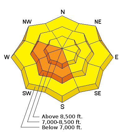
Today, the greatest avalanche danger will be wet slides, both natural and human triggered. The sun will rapidly heat the cold snow, first on easterly facing slopes, then south, then westerly. Wet loose sluffs will become easy to trigger, and natural avalanches will likely be occurring by this afternoon, if not earlier. These wet slides will be most dangerous in continuous steep terrain, especially confined gullies, where they can run long distances and the debris pile up deeply. With the high sun angle and periods of high thin clouds, the snow will also get damp on low to mid elevation northerly facing slopes, too. Be very alert to whether the snow is heating where you are, and quickly move to a cooler aspect, getting off steep slopes as soon as the snow becomes damp, roller balls start to swarm or you can trigger damp sluffs. |
| type | aspect/elevation | characteristics |
|---|

|

|
LIKELIHOOD
 LIKELY
UNLIKELY
SIZE
LARGE
SMALL
TREND
 INCREASING DANGER
SAME
DECREASING DANGER
|
|
description
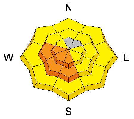
There will still be sensitive soft to medium hard wind drifts that can be triggered by a person today. They will be most widespread in upper elevation terrain, both along the upper elevation ridgelines and down into open bowls, especially on easterly facing slopes. These wind slabs are large enough to catch and carry a person who is on foot, and could result in a nasty ride if you were sent speeding into trees or off a cliff. |
 |
weather After an amazing last week of “winter”, the switch has been turned to spring today. Ridge line temperatures will warm to into upper 20s, 8000’ temperatures into the low to mid 40s. The early morning clouds will decrease rapidly, and it will turn into a mostly sunny day, with just a few high thin clouds. The northwesterly winds should also decrease all day, with most stations averaging around 10 mph by afternoon, and only the highest ridge lines still gusting to 40 mph. High pressure will park over Utah through about Friday, with warm, above average temperatures and plenty of sunshine. |
| general announcements Remember your information can save lives. If you see anything we should know about, please participate in the creation of our own community avalanche advisory by submitting snow and avalanche conditions. You can also call us at 801-524-5304 or 800-662-4140, email by clicking HERE, or include #utavy in your tweet or Instagram. If you trigger an avalanche in the backcountry - especially if you are adjacent to a ski area – please call the following teams to alert them to the slide and whether anyone is missing or not. Rescue teams can be exposed to significant hazard when responding to avalanches, and do not want to do so when unneeded. Thanks. Salt Lake and Park City – Alta Central (801-742-2033), Canyons Resort Dispatch (435-615-3322) Snowbasin Resort Dispatch (801-620-1017), Powder Mountain Dispatch (801-745-3772 x 123). Sundance Dispatch (801-223-4150) EMAIL ADVISORY We have switched to a new SLC email advisory system. If you would like to get the daily advisory by email, or if you have been getting the advisory by email since the beginning of the season and wish to continue, you will need to subscribe here. DAWN PATROL Hotline updated daily by 5-530am - 888-999-4019 option 8. Twitter Updates for your mobile phone - DETAILS UDOT canyon closures: LINK TO UDOT Utah Avalanche Center mobile app - Get your advisory on your iPhone along with great navigation and rescue tools.uned. Wasatch Powderbird Guides Blog/Itinerary for the Day. Lost or Found something in the backcountry? - http://nolofo.com/ Discount lift tickets are now available at Backcountry.com - Thanks to Ski Utah and the Utah Resorts. All proceeds go towards paying for Utah Avalanche Center avalanche and mountain weather advisories. To those skinning uphill at resorts: it is your responsibility to know the resort policy on uphill travel. Some allow uphill travel and have guidelines, some don't. Contact the Ski Patrol at each resort for details. IMPORTANT: Before skinning at a resort under new snow conditions, check in with Ski Patrol. Resorts can restrict or cut off access if incompatible with control and grooming operations. Benefit the Utah Avalanche Center when you shop from Backcountry.com or REI: Click this link for Backcountry.com or this link to REI, shop, and they will donate a percent of your purchase price to the UAC. Both offer free shipping (with some conditions) so this costs you nothing! Benefit the Utah Avalanche Center when you buy or sell on ebay - set the Utah Avalanche Center as a favorite non-profit in your ebay account here and click on ebay gives when you buy or sell. You can choose to have your seller fees donated to the UAC, which doesn't cost you a penny. This information does not apply to developed ski areas or highways where avalanche control is normally done. This advisory is from the U.S.D.A. Forest Service, which is solely responsible for its content. This advisory describes general avalanche conditions and local variations always exist. |


_4.jpg)