| During the month of April, Mark Miller will donate $75 to the charity of your choice (5 to chose from, including the Utah Avalanche Center!) Mark Miller Subaru has raised over $300k in the previous 6 Do Good Feel Good events. More Info here |  |
| During the month of April, Mark Miller will donate $75 to the charity of your choice (5 to chose from, including the Utah Avalanche Center!) Mark Miller Subaru has raised over $300k in the previous 6 Do Good Feel Good events. More Info here | |
| Advisory: Ogden Area Mountains | Issued by Evelyn Lees for Thursday - April 3, 2014 - 7:05am |
|---|

|
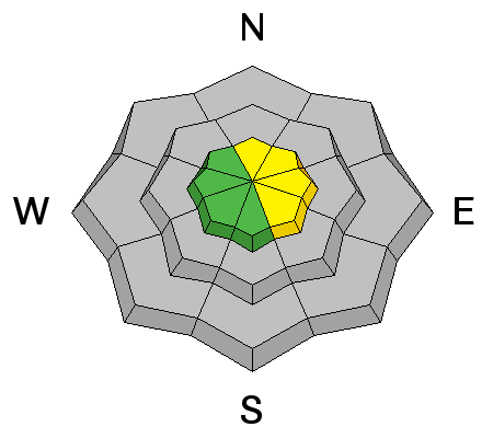
bottom line The avalanche danger will rapidly rise MODERATE and even CONSIDERABLE for WET AVALANCHES today – whenever the sun heats the snow. Both human triggered and natural will be possible on steep slopes of almost all aspects and elevations. Early starts and early finishes are key - get off of and out from under steep slopes as the snow heats up. In addition, it is possible to trigger shallow soft wind drifts and dry sluffs on steep, upper elevation slopes, especially those facing north and east.
|
 |
special announcement SALE! on all remaining discount lift tickets donated to the Utah Avalanche Center from Snowbasin, the Canyons, Beaver Mountain, Sundance, and Brian Head: The few remaining tickets are being blown out with all proceeds used to pay for avalanche advisories and education. Go here to get your tickets. |
 |
current conditions Under partly skies, winter temperatures are still in effect this morning – in the twenties at the low and mid elevations, with a few teens along the high ridge lines in the Ogden area mountains. The northwesterly winds are very light, in the 5 to 10 mph range, with most gusts only to 15 mph. Storm totals (since Monday night): 1 to 2 feet in the Cottonwoods, up to a foot on the Park City side, 6 to 12 in the Ogden mountains, and up to 8” in the Provo area mountains. With only occasional sun yesterday, early risers will still find widespread powder this morning, especially on northerly facing slopes. |
 |
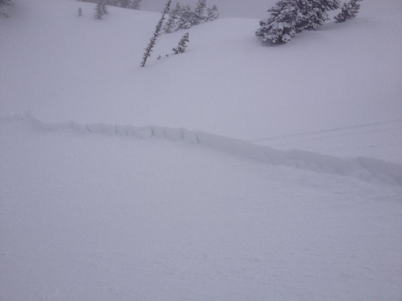
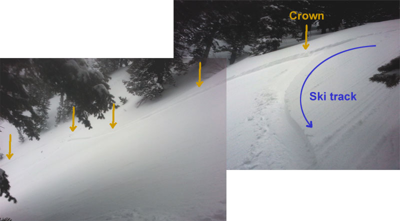
recent activity New snow soft slabs and sluffs were triggered yesterday, especially on steeper, upper elevation slopes with a bit of wind loading. One person was caught and reportedly had a fairly long ride down Little Superior’s south side yesterday. An intentional ski cut in NE facing Days Fork triggered a slide about 70’ wide (J Camps, upper photo) A slightly larger slide was triggered in Hells Canyon, Ogden area mountains, where just a touch of sun made the snow on a SE facing slope sensitive - 9" x 150' wide, taking out two layers of snow. (lower photo PC Kevin S) This slide seemed to have both dry and wet characteristics, perhaps foreshadowing what is to come today.
|
| type | aspect/elevation | characteristics |
|---|

|
|
LIKELIHOOD
 LIKELY
UNLIKELY
SIZE
 LARGE
SMALL
TREND
 INCREASING DANGER
SAME
DECREASING DANGER
|
|
description
Today, we will finally loose the protection of thick clouds, and have a mix of clouds and clearing. Anytime the strong spring sun breaks through the clouds, it will rapidly heat the cold, dry snow, resulting in wet sluffs. Heating could happen surprisingly fast today – almost instantly when the sun hits a slope, and what starts as a seemingly dry snow sluff or soft slab may rapidly take on the characteristics of a dense, wet snow slide as it moves down slope. So if you are being chased down slope by swarms of roller balls, wet sluffs could soon follow, and it’s time to get off that slope. These wet sluffs can be dangerous - long running in confined gullies, very dense debris, and piling up deeply in terrain traps such as flatter benches and gully bottoms. Mid and lower elevation northerly facing slopes will get in on the wet action, too, especially with any periods of high thin clouds. |
| type | aspect/elevation | characteristics |
|---|

|
|
LIKELIHOOD
 LIKELY
UNLIKELY
SIZE
LARGE
SMALL
TREND
 INCREASING DANGER
SAME
DECREASING DANGER
|
|
description
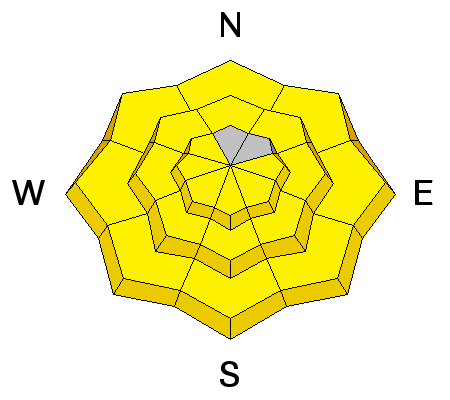
On upper elevation slopes early this morning, and high northerly facing slopes throughout the day, it will still be possible to trigger a few soft wind drifts and dry sluffs in the newest snow, large enough to catch and carry a person. |
 |
weather High pressure moving in will limit cloud cover today, and any snow showers will be short lived. Temperatures will be slow to warm, remaining in the teens at 10,000’, and warming into the upper 20s at 8,000’. Sun and very light winds will make it feel much warmer though – the northwesterly winds will remain in the 5 to 15 mph range at all elevations. Partly cloudy skies tonight and most of Friday. Then late Friday through Sunday a disorganized low pressure system will slowly move through, with weak waves producing periods of light snow Saturday and then Sunday. We’re hoping for another 5 to 10” in the Friday night through Sunday time period. The spoiler will be increasing winds on Sunday. Then strong high pressure will build in on Monday, and remain over northern Utah trough at least mid-week, with rapid warming, 10,000’ temperatures into the 40ks. |
| general announcements Remember your information can save lives. If you see anything we should know about, please participate in the creation of our own community avalanche advisory by submitting snow and avalanche conditions. You can also call us at 801-524-5304 or 800-662-4140, email by clicking HERE, or include #utavy in your tweet or Instagram. If you trigger an avalanche in the backcountry - especially if you are adjacent to a ski area – please call the following teams to alert them to the slide and whether anyone is missing or not. Rescue teams can be exposed to significant hazard when responding to avalanches, and do not want to do so when unneeded. Thanks. Salt Lake and Park City – Alta Central (801-742-2033), Canyons Resort Dispatch (435-615-3322) Snowbasin Resort Dispatch (801-620-1017), Powder Mountain Dispatch (801-745-3772 x 123). Sundance Dispatch (801-223-4150) EMAIL ADVISORY We have switched to a new SLC email advisory system. If you would like to get the daily advisory by email, or if you have been getting the advisory by email since the beginning of the season and wish to continue, you will need to subscribe here. DAWN PATROL Hotline updated daily by 5-530am - 888-999-4019 option 8. Twitter Updates for your mobile phone - DETAILS UDOT canyon closures: LINK TO UDOT Utah Avalanche Center mobile app - Get your advisory on your iPhone along with great navigation and rescue tools.uned. Wasatch Powderbird Guides Blog/Itinerary for the Day. Lost or Found something in the backcountry? - http://nolofo.com/ Discount lift tickets are now available at Backcountry.com - Thanks to Ski Utah and the Utah Resorts. All proceeds go towards paying for Utah Avalanche Center avalanche and mountain weather advisories. To those skinning uphill at resorts: it is your responsibility to know the resort policy on uphill travel. Some allow uphill travel and have guidelines, some don't. Contact the Ski Patrol at each resort for details. IMPORTANT: Before skinning at a resort under new snow conditions, check in with Ski Patrol. Resorts can restrict or cut off access if incompatible with control and grooming operations. Benefit the Utah Avalanche Center when you shop from Backcountry.com or REI: Click this link for Backcountry.com or this link to REI, shop, and they will donate a percent of your purchase price to the UAC. Both offer free shipping (with some conditions) so this costs you nothing! Benefit the Utah Avalanche Center when you buy or sell on ebay - set the Utah Avalanche Center as a favorite non-profit in your ebay account here and click on ebay gives when you buy or sell. You can choose to have your seller fees donated to the UAC, which doesn't cost you a penny. This information does not apply to developed ski areas or highways where avalanche control is normally done. This advisory is from the U.S.D.A. Forest Service, which is solely responsible for its content. This advisory describes general avalanche conditions and local variations always exist. |


_4.jpg)