| During the month of April, Mark Miller will donate $75 to the charity of your choice (5 to chose from, including the Utah Avalanche Center!) Mark Miller Subaru has raised over $300k in the previous 6 Do Good Feel Good events. More Info here |  |
| During the month of April, Mark Miller will donate $75 to the charity of your choice (5 to chose from, including the Utah Avalanche Center!) Mark Miller Subaru has raised over $300k in the previous 6 Do Good Feel Good events. More Info here | |
| Advisory: Ogden Area Mountains | Issued by Drew Hardesty for Wednesday - April 2, 2014 - 7:15am |
|---|

|
bottom line Yesterday's danger started at MODERATE and reached CONSIDERABLE by the afternoon...today's danger will start at CONSIDERABLE and trend toward MODERATE. I'd expect human triggered avalanches to be probable on many aspects today with soft slabs and longer running loose snow avalanches likely. Knowing the Wasatch backcountry, I'd be surprised if I didn't hear about a few people taking rides in avalanches today. If the sun comes out, all bets are off and both human and natural sluffs and storm snow slides will be all but certain.
|
 |
special announcement SALE! on all remaining discount lift tickets donated to the Utah Avalanche Center from Snowbasin, the Canyons, Beaver Mountain, Sundance, and Brian Head: The few remaining tickets are being blown out with all proceeds used to pay for avalanche advisories and education. Go here to get your tickets. Utah Avalanche Center History: On a personal note, it's been exceptionally rewarding having spent the last couple of months tracking down and connecting with long retired or otherwise "off to snowier pastures" forecasters from days gone by, to include families and not just a couple widows. Some names may be familiar - Tom Kimbrough still climbs and skis into his mid-70s; the famed alpinists Alex Lowe and Seth Shaw; or who could forget the firebrand snow scientist Ed LaChapelle protege Sue Ferguson? and may others...Much has changed in the past 35 years, but all the forecasters share a common bond in the rich history of snow and avalanches in the Wasatch Range. Their stories can be found off of our UAC Staff page here. - Hardesty |
 |
current conditions Speaking for myself, there's nothing like blowing a weather forecast. Yesterday's cold front came in like a freight train - with my projected storm totals of 8-10" looking more like 18" in the upper Cottonwoods, 13-15" along the Park City ridgeline, and 6-10" in the Ogden and Provo mountains. These numbers from Monday night through, effectively, last night. Underpromise and over-deliver, I say. Prior to, and just after the midday system, winds picked up from the south and southwest, blowing 25-30mph along the ridgelines with subsequent snowfall rates in the 1-2"/hour range - if not more in localized terrain. This - of course - preceded by what the Pacific Northwesters affectionately call "sun-breaks" - which led to "green-housing' and a whole other slew of avalanche problems. Must be spring. Like Bruce's 96 year old Czech mother-in-law likes so say, "Spreng es always a fight between winter and summer". More maddening is that there is so much spatial variability to where things are happening - it's greenhousing in this drainage, but convective showers are blowing graupel in at 3"/hour in that drainage. Did I mention lightning? It's enough to turn your hair, and beard, gray. Currently, skies are mostly cloudy, temps are in the mid-teens, winds are from the west and northwest and less than 15mph...and have been for most of the night. Could it be that the best day of the year was on April Fool's? |
 |
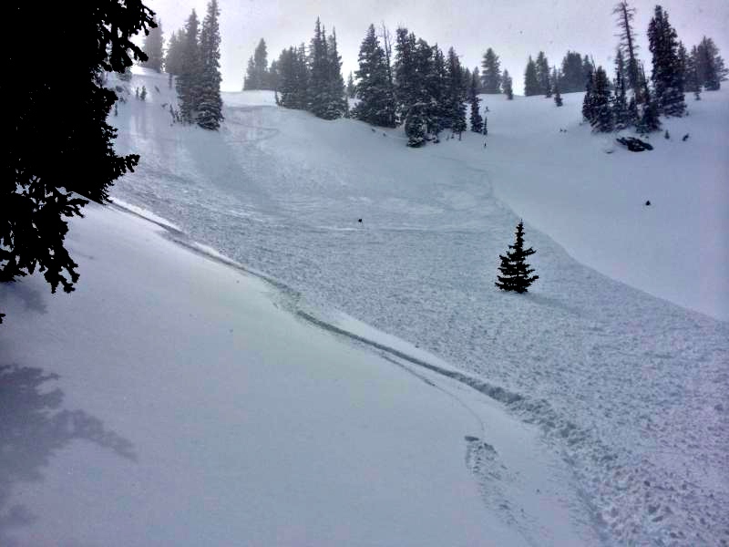
recent activity In the spring, conditions can turn on a dime and the danger easily spiked toward Considerable in the early afternoon with almost all the boxes checked for active conditions - avalanche activity, cracking, collapsing, cornice fall - you name it. Most of these were in lock-step with the periods of high snowfall intensity and the onset of wind. Many of the new snow instabilities were running remote to the skiers (triggered from a distance) - as can be the case with periods of high snowfall rates with low density snow/stellar interfaces. Slides averaged 12-18" deep and 100" wide with some showing wider propagation. (photo Mletschnig)
Prior to this, the warmth/sun breaks/greenhousing immediately affected the cold dry snow, with human triggered wet sluffs noted in steeper east facing terrain.
Last, but not least, a quick shout out to those who called Alta Central when they triggered an avalanche adjacent to the mountain resorts/state roads - thanks - It's key to alert them to the slide and whether anyone is missing or not. Rescue teams can be exposed to significant hazard when responding to avalanches, and do not want to do so when unneeded. See local contact info for Alta Central/PC/Ogden/Provo areas in our General Announcements, below. |
| type | aspect/elevation | characteristics |
|---|

|

|
LIKELIHOOD
 LIKELY
UNLIKELY
SIZE
 LARGE
SMALL
TREND
 INCREASING DANGER
SAME
DECREASING DANGER
|
|
description
The height of the instability was in the afternoon and should be trending down, albeit slowly, throughout the day. With multiple weak interfaces, I'd still approach slopes approaching 35 degrees and steeper with caution and use all the classic tricks of the trade to gauge how quickly things are healing. In other words, test slopes, hand pits, cornice drops, and slope cuts should all give some information on current conditions. True, the rapid loading occurred yesterday, but low density interfaces can take longer to heal. Having said this, all bets are off if the sun comes out for any period of the day or the cold dry snow becomes damp. When this occurs, conditions change quickly and dramatically, and human triggered slides of wet sluffs are all but certain.
|
| type | aspect/elevation | characteristics |
|---|

|
|
LIKELIHOOD
LIKELY
UNLIKELY
SIZE
LARGE
SMALL
TREND
INCREASING DANGER
SAME
DECREASING DANGER
|
|
description
Drifting was evident by midday and noted along the west to north to east facing steeper terrain. These drifts were soft and remotely triggered - and lingering but less sensitive today. As with the storm snow, I'd consider the lee of ridgelines suspect unless proven otherwise. The standard tool-box (see above) used by experienced backcountry travelers should give some indication of localized instability. Should be common sense, but with increasing numbers of close calls among parties - Don't drop cornices, slope cut, or ride the slope with other parties below. |
| type | aspect/elevation | characteristics |
|---|

|
|
LIKELIHOOD
LIKELY
UNLIKELY
SIZE
LARGE
SMALL
TREND
 INCREASING DANGER
SAME
DECREASING DANGER
|
|
description
Longer running sluffs that can pack a punch can be initiated on slopes approaching 40 degrees and steeper today...they'll be accentuated if the sun pokes through, but sluff management will be key with the moving snow. |
 |
weather We'll have overcast to mostly cloudy skies today. Winds will be generally 10-15mph from the west and northwest. Temps will be in the upper teens at 10,000' and the upper 20s at 8000'. We'll be in the cradle of a large open trough with the bulk of the activity happening today in southern and central Utah. We may see some instability showers in the afternoon. Shortwave ridging builds for tomorrow with partly cloudy skies...ahead of the next storm system Friday night through the weekend. Looks like high pressure builds for a major melt down next week. Ridgetop temps forecasted to soar the near 50 by the end of the week. |
| general announcements
Remember your information can save lives. If you see anything we should know about, please participate in the creation of our own community avalanche advisory by submitting snow and avalanche conditions. You can also call us at 801-524-5304 or 800-662-4140, email by clicking HERE, or include #utavy in your tweet or Instagram. If you trigger an avalanche in the backcountry - especially if you are adjacent to a ski area – please call the following teams to alert them to the slide and whether anyone is missing or not. Rescue teams can be exposed to significant hazard when responding to avalanches, and do not want to do so when unneeded. Thanks. Salt Lake and Park City – Alta Central (801-742-2033), Canyons Resort Dispatch (435-615-3322) Snowbasin Resort Dispatch (801-620-1017), Powder Mountain Dispatch (801-745-3772 x 123). Sundance Dispatch (801-223-4150) EMAIL ADVISORY We have switched to a new SLC email advisory system. If you would like to get the daily advisory by email, or if you have been getting the advisory by email since the beginning of the season and wish to continue, you will need to subscribe here. DAWN PATROL Hotline updated daily by 5-530am - 888-999-4019 option 8. Twitter Updates for your mobile phone - DETAILS UDOT canyon closures: LINK TO UDOT Utah Avalanche Center mobile app - Get your advisory on your iPhone along with great navigation and rescue tools.uned. Wasatch Powderbird Guides Blog/Itinerary for the Day. Lost or Found something in the backcountry? - http://nolofo.com/ Discount lift tickets are now available at Backcountry.com - Thanks to Ski Utah and the Utah Resorts. All proceeds go towards paying for Utah Avalanche Center avalanche and mountain weather advisories. To those skinning uphill at resorts: it is your responsibility to know the resort policy on uphill travel. Some allow uphill travel and have guidelines, some don't. Contact the Ski Patrol at each resort for details. IMPORTANT: Before skinning at a resort under new snow conditions, check in with Ski Patrol. Resorts can restrict or cut off access if incompatible with control and grooming operations. Benefit the Utah Avalanche Center when you shop from Backcountry.com or REI: Click this link for Backcountry.com or this link to REI, shop, and they will donate a percent of your purchase price to the UAC. Both offer free shipping (with some conditions) so this costs you nothing! Benefit the Utah Avalanche Center when you buy or sell on ebay - set the Utah Avalanche Center as a favorite non-profit in your ebay account here and click on ebay gives when you buy or sell. You can choose to have your seller fees donated to the UAC, which doesn't cost you a penny. This information does not apply to developed ski areas or highways where avalanche control is normally done. This advisory is from the U.S.D.A. Forest Service, which is solely responsible for its content. This advisory describes general avalanche conditions and local variations always exist. |


_4.jpg)