
| During the month of April, Mark Miller will donate $75 to the charity of your choice (5 to chose from, including the Utah Avalanche Center!) Mark Miller Subaru has raised over $300k in the previous 6 Do Good Feel Good events. More Info here |  |
| During the month of April, Mark Miller will donate $75 to the charity of your choice (5 to chose from, including the Utah Avalanche Center!) Mark Miller Subaru has raised over $300k in the previous 6 Do Good Feel Good events. More Info here | |
| Advisory: Ogden Area Mountains | Issued by Brett Kobernik for Sunday - March 30, 2014 - 7:17am |
|---|


|
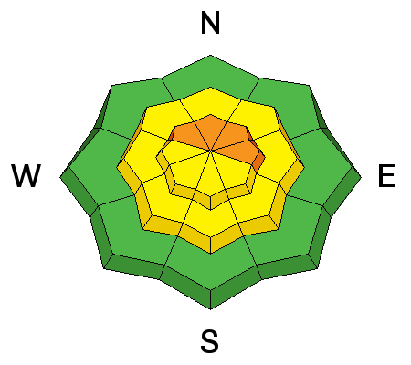
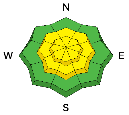
bottom line The avalanche danger is increasing and may reach CONSIDERABLE mid day with continued wind and the onset of heavy snowfall. The danger is most pronounced in the upper elevation northwest through east facing slopes with recent deposits of wind drifted snow. The danger is MODERATE out of the windy areas. Watch for instabilities within the anticipated new snow.
|
 |
special announcement SALE! on all remaining discount lift tickets donated to the Utah Avalanche Center from Snowbasin, the Canyons, Beaver Mountain, Sundance, and Brian Head: The few remaining tickets are being blown out with all proceeds used to pay for avalanche advisories and education. Go here to get your tickets. |
 |
current conditions Strong and blustery southwest winds continued last night and will continue to increase in speed a bit more this morning. Ridgetop temperatures were mild overnight with many stations in the mid 30s. There was quite a bit of wind transported snow happening on Saturday as well as extensive wind damage in the upper elevations. The snow is damp and becoming unsupportable at the lower elevations. |
 |
recent activity There were no avalanches reported from the Ogden area mountains but a number of wind slabs were triggered in the Salt Lake and Provo area mountains:
|
| type | aspect/elevation | characteristics |
|---|

|
|
LIKELIHOOD
 LIKELY
UNLIKELY
SIZE
 LARGE
SMALL
TREND
 INCREASING DANGER
SAME
DECREASING DANGER
|
|
description
Let's take a look at what's going on with the wind slabs. The last storm was a bit windy and we quickly found sensitive wind slabs during the storm. Some of these slabs remained sensitive Friday and again yesterday with some additional wind loading. Some 'near surface facets' may be involved with the lingering instability as recently noted by UDOT forecasters Bill Nalli (AVALANCHE-Pioneer) and Matt Primomo (OBSERVATION-Chablis). This isn't a major avalanche problem but what's happening is when the avalanche danger is not very high, we tend to accept more risk and go into more committing terrain, myself included. It's nice that we are not dealing with the deep slab issue from earlier this season but we can't let our guard down. These types of wind slabs are what killed a skier on Kessler late in the season last year. Obviously, the overnight winds will have continued to enhance the wind slabs, albeit, they're probably more stubborn. They will also get hidden by today's snow making them hard to recognize. Video: Propagation Saw Test on facets 2014-03-29 PST 30/100 (End) from Matt Primomo on Vimeo. |
| type | aspect/elevation | characteristics |
|---|

|
|
LIKELIHOOD
LIKELY
UNLIKELY
SIZE
 LARGE
SMALL
TREND
INCREASING DANGER
SAME
DECREASING DANGER
|
|
description
As with any new snow, we need to anticipate that it may not bond well to the old snow or there may be instabilities within the new snow itself. It is fairly easy to figure out. We look for clean easy shears in the snow by cutting above existing tracks on test slopes, digging quick hand pits, and using shovel tilt tests. This avalanche problem will be most pronounced this afternoon during and right after the higher snowfall rates. |
 |
weather Southerly winds will continue this morning. There may be some pre-frontal moisture with snow flurries this morning. The cold front is expected around noon or even a bit later which is when we'll see heavy snowfall start and last for a few hours before turning more steady and continuing into tonight. Most areas should see around 6 inches or perhaps a bit more in favored locations. We'll have a break in the weather on Monday then more chances for snow Monday night into Wednesday. |
| general announcements Remember your information can save lives. If you see anything we should know about, please participate in the creation of our own community avalanche advisory by submitting snow and avalanche conditions. You can also call us at 801-524-5304 or 800-662-4140, email by clicking HERE, or include #utavy in your tweet or Instagram. If you trigger an avalanche in the backcountry - especially if you are adjacent to a ski area – please call the following teams to alert them to the slide and whether anyone is missing or not. Rescue teams can be exposed to significant hazard when responding to avalanches, and do not want to do so when unneeded. Thanks. Salt Lake and Park City – Alta Central (801-742-2033), Canyons Resort Dispatch (435-615-3322) Snowbasin Resort Dispatch (801-620-1017), Powder Mountain Dispatch (801-745-3772 x 123). Sundance Dispatch (801-223-4150) EMAIL ADVISORY We have switched to a new SLC email advisory system. If you would like to get the daily advisory by email, or if you have been getting the advisory by email since the beginning of the season and wish to continue, you will need to subscribe here. DAWN PATROL Hotline updated daily by 5-530am - 888-999-4019 option 8. Twitter Updates for your mobile phone - DETAILS UDOT canyon closures: LINK TO UDOT Utah Avalanche Center mobile app - Get your advisory on your iPhone along with great navigation and rescue tools.uned. Wasatch Powderbird Guides Blog/Itinerary for the Day. Lost or Found something in the backcountry? - http://nolofo.com/ Discount lift tickets are now available at Backcountry.com - Thanks to Ski Utah and the Utah Resorts. All proceeds go towards paying for Utah Avalanche Center avalanche and mountain weather advisories. To those skinning uphill at resorts: it is your responsibility to know the resort policy on uphill travel. Some allow uphill travel and have guidelines, some don't. Contact the Ski Patrol at each resort for details. IMPORTANT: Before skinning at a resort under new snow conditions, check in with Ski Patrol. Resorts can restrict or cut off access if incompatible with control and grooming operations. Benefit the Utah Avalanche Center when you shop from Backcountry.com or REI: Click this link for Backcountry.com or this link to REI, shop, and they will donate a percent of your purchase price to the UAC. Both offer free shipping (with some conditions) so this costs you nothing! Benefit the Utah Avalanche Center when you buy or sell on ebay - set the Utah Avalanche Center as a favorite non-profit in your ebay account here and click on ebay gives when you buy or sell. You can choose to have your seller fees donated to the UAC, which doesn't cost you a penny. This information does not apply to developed ski areas or highways where avalanche control is normally done. This advisory is from the U.S.D.A. Forest Service, which is solely responsible for its content. This advisory describes general avalanche conditions and local variations always exist. |


_4.jpg)