| During the month of April, Mark Miller will donate $75 to the charity of your choice (5 to chose from, including the Utah Avalanche Center!) Mark Miller Subaru has raised over $300k in the previous 6 Do Good Feel Good events. More Info here |  |
| During the month of April, Mark Miller will donate $75 to the charity of your choice (5 to chose from, including the Utah Avalanche Center!) Mark Miller Subaru has raised over $300k in the previous 6 Do Good Feel Good events. More Info here | |
| Advisory: Ogden Area Mountains | Issued by Bruce Tremper for Friday - March 28, 2014 - 7:02am |
|---|

|
bottom line Avoid: 1) steep slopes with recent wind deposits, 2) slopes where the sun turns the snow wet (and stay out from underneath). Safer terrain: terrain with non-wind drifted snow and gentler slopes with low consequences. We base avalanche danger ratings on both probability and consequences. Today, it will be fairly easy to trigger a sluff, wind slab or wet, loose avalanche but the snow is mostly soft and relatively shallow, which I will call a MODERATE danger. You should avoid high consequence terrain today such as large paths or slopes with obstacles such as trees, rocks or cliffs and slopes that end in terrain traps like gullies.
|
 |
special announcement SALE! on all remaining discount lift tickets donated to the Utah Avalanche Center from Snowbasin, the Canyons, Beaver Mountain, Sundance, and Brian Head: The few remaining tickets are being blown out with all proceeds used to pay for avalanche advisories and education. Go here to get your tickets. |
 |
current conditions The last few showers from this storm are sprinkling the mountains with a bit more snow this morning which should end by mid morning. Yesterday, there was very nice, light powder on a hard, icy crust. Temperatures are in the mid 20's with ridge top winds 15-25 with higher gusts from the west. Storm totals are 10-16 inches in the Cottonwood Canyons with 7 inches on the Park City side, Ogden and Provo area mountains. Snow is medium to low density and it rides fast in gentle terrain. but it's wind affected near the high ridges. |
 |
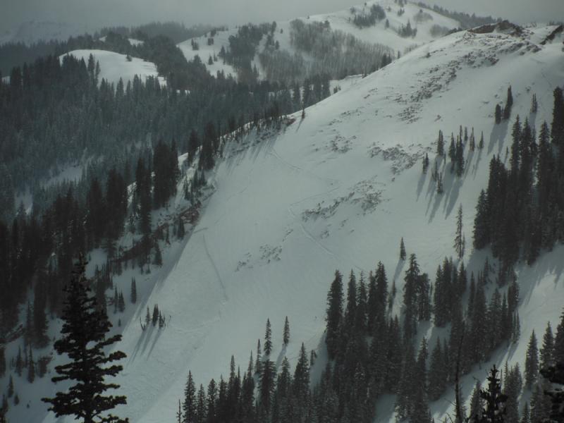
recent activity We heard about a half dozen human triggered wind slabs in the backcountry yesterday, mostly along the upper elevation ridges but one in Dutch Draw near the Canyons Resort occurred down off the ridge and the person skied off the slab. Two others caught and carried skiers, one on the edges of Wolverine Cirque and one on the south face of Superior. For the most part, the snow was well behaved and just sluffed easily on slopes approaching 40 degrees sliding easily on the old, hard icy crust. But in localized areas the wind had its way and created some soft slabs about a foot deep but up to 2 feet deep at high elevations.
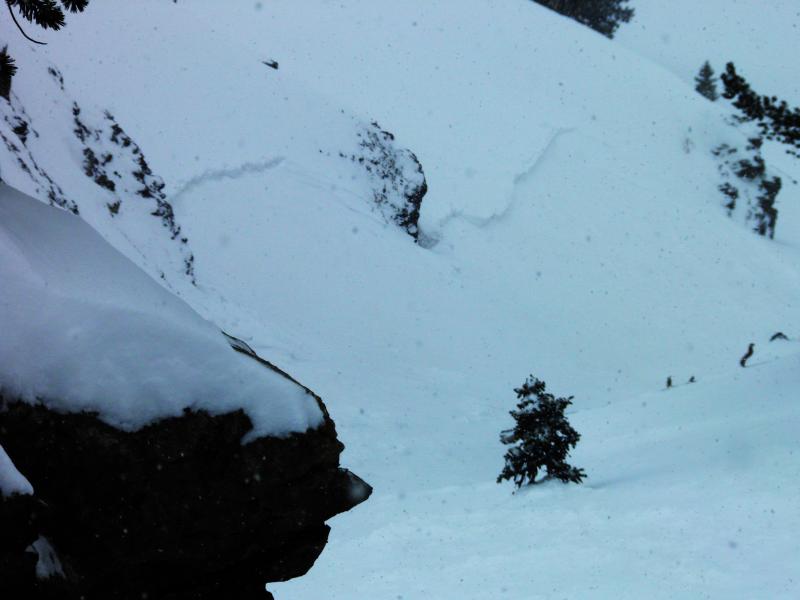
Human triggered soft slab in Dutch Draw. They skied off the slab.
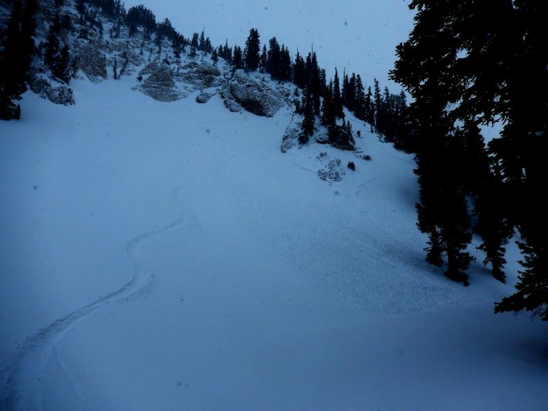
Skier triggered wind slab in Day's Fork.
Skier triggered soft slab on Pioneer Ridge on pre-existing faceted snow. |
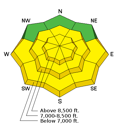
| type | aspect/elevation | characteristics |
|---|

|
|
LIKELIHOOD
 LIKELY
UNLIKELY
SIZE
 LARGE
SMALL
TREND
 INCREASING DANGER
SAME
DECREASING DANGER
|
|
description
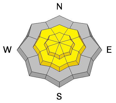
Today, you should continue to find localized, sensitive, deposits of wind drifted snow, mostly along the upper elevation ridges, both from yesterday's wind and continued wind today. Watch for the characteristic, slabby feel and the smooth, rounded shape. The slab character can change quickly and dramatically from one place to another, so they require constant attention. These soft slabs are around a foot deep and they slide easily on the old, icy crust and on the northerly aspects, there may be some faceted snow on the old snow surface, which will make these slabs persistently sensitive. Today is probably not the day for high consequence terrain. Down, out of the wind zone, the snow is much better behaved but it will sluff easily on slopes approaching 40 degrees or steeper. |
| type | aspect/elevation | characteristics |
|---|

|
|
LIKELIHOOD
LIKELY
UNLIKELY
SIZE
LARGE
SMALL
TREND
 INCREASING DANGER
SAME
DECREASING DANGER
|
|
description
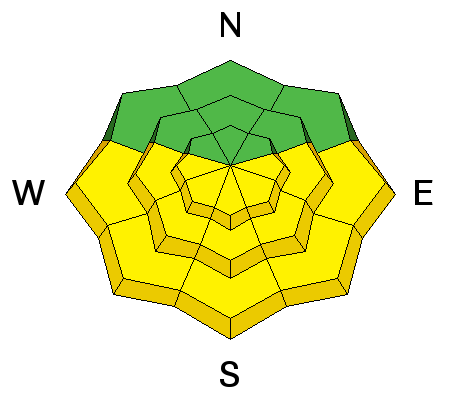
The forecast is for quite a bit of sun later this morning and this afternoon. Our strong, spring sun will change the cold, dry snow to damp or wet snow in a hurry. Watch for pinwheels in the new snow and point-release damp to wet sluffs within the new snow. Be sure to get off of, and out from underneath, steep slopes when they start to get wet. On larger slide paths, these could pile up quite deeply and you should avoid other high consequence terrain. |
 |
weather We will have a few lingering snow showers this morning but skies should be mostly clear by mid day with plenty of sun to turn our dry snow wet in a hurry. Temperatures will rise from the mid 20's into the mid to upper 30's by afternoon. Hopefully, the wind will help to keep things cool. We should continue to see moderate wind along the upper elevation ridges, blowing 20-30 from the west. In advance of yet another storm on Sunday, overnight we will see wind blow from the southwest and steadily increase in speed, becoming strong on Saturday. Sunday's storm looks to be 8-12 inches of additional snow. |
| general announcements Remember your information can save lives. If you see anything we should know about, please participate in the creation of our own community avalanche advisory by submitting snow and avalanche conditions. You can also call us at 801-524-5304 or 800-662-4140, email by clicking HERE, or include #utavy in your tweet or Instagram. If you trigger an avalanche in the backcountry - especially if you are adjacent to a ski area – please call the following teams to alert them to the slide and whether anyone is missing or not. Rescue teams can be exposed to significant hazard when responding to avalanches, and do not want to do so when unneeded. Thanks. Salt Lake and Park City – Alta Central (801-742-2033), Canyons Resort Dispatch (435-615-3322) Snowbasin Resort Dispatch (801-620-1017), Powder Mountain Dispatch (801-745-3772 x 123). Sundance Dispatch (801-223-4150) EMAIL ADVISORY We have switched to a new SLC email advisory system. If you would like to get the daily advisory by email, or if you have been getting the advisory by email since the beginning of the season and wish to continue, you will need to subscribe here. DAWN PATROL Hotline updated daily by 5-530am - 888-999-4019 option 8. Twitter Updates for your mobile phone - DETAILS UDOT canyon closures: LINK TO UDOT Utah Avalanche Center mobile app - Get your advisory on your iPhone along with great navigation and rescue tools.uned. Wasatch Powderbird Guides Blog/Itinerary for the Day. Lost or Found something in the backcountry? - http://nolofo.com/ Discount lift tickets are now available at Backcountry.com - Thanks to Ski Utah and the Utah Resorts. All proceeds go towards paying for Utah Avalanche Center avalanche and mountain weather advisories. To those skinning uphill at resorts: it is your responsibility to know the resort policy on uphill travel. Some allow uphill travel and have guidelines, some don't. Contact the Ski Patrol at each resort for details. IMPORTANT: Before skinning at a resort under new snow conditions, check in with Ski Patrol. Resorts can restrict or cut off access if incompatible with control and grooming operations. Benefit the Utah Avalanche Center when you shop from Backcountry.com or REI: Click this link for Backcountry.com or this link to REI, shop, and they will donate a percent of your purchase price to the UAC. Both offer free shipping (with some conditions) so this costs you nothing! Benefit the Utah Avalanche Center when you buy or sell on ebay - set the Utah Avalanche Center as a favorite non-profit in your ebay account here and click on ebay gives when you buy or sell. You can choose to have your seller fees donated to the UAC, which doesn't cost you a penny. This information does not apply to developed ski areas or highways where avalanche control is normally done. This advisory is from the U.S.D.A. Forest Service, which is solely responsible for its content. This advisory describes general avalanche conditions and local variations always exist. |


_4.jpg)