| During the month of April, Mark Miller will donate $75 to the charity of your choice (5 to chose from, including the Utah Avalanche Center!) Mark Miller Subaru has raised over $300k in the previous 6 Do Good Feel Good events. More Info here |  |
| During the month of April, Mark Miller will donate $75 to the charity of your choice (5 to chose from, including the Utah Avalanche Center!) Mark Miller Subaru has raised over $300k in the previous 6 Do Good Feel Good events. More Info here | |
| Advisory: Ogden Area Mountains | Issued by Brett Kobernik for Friday - March 14, 2014 - 7:15am |
|---|


|
bottom line There is a mostly LOW avalanche danger today. Watch for fresh wind slabs along the high lee sides of ridges. Keep an eye on the sunny slopes as they heat up and move off of and out from under them if they get too wet.
|
 |
current conditions We had a nice cold clear night overnight with most stations reading in the low 20s. West southwest winds increased in speed slightly late Thursday but have tapered off again. There was some snow transport and the wind did do a little damage. |
| type | aspect/elevation | characteristics |
|---|

|
|
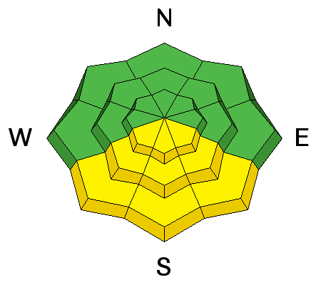
LIKELIHOOD
 LIKELY
UNLIKELY
SIZE
 LARGE
SMALL
TREND
 INCREASING DANGER
SAME
DECREASING DANGER
|
|
description
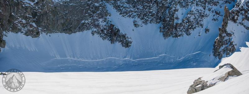
We have fairly safe avalanche conditions right now. You will be hard pressed to find an avalanche in most terrain today. Reviewing some of the recent activity and the related avalanche problem will remind us of areas where we may trigger something today. Wind Slabs: This is a very manageable avalanche problem for those with avalanche training and experience. However, keep in mind that in radical terrain, even a small avalanche may not be manageable as documented in a new avalanche observation from Monte Cristo that some skiers triggered a couple of days ago. DETAILS on a good write up. Persistent Slabs: Low probability unless you are getting into steep radical terrain. A close call in Mineral Fork from two days ago illustrates perfectly how you might still find some older facets that might collapse and fail. DETAILS Wet Avalanches: Even though it will be slightly warmer today than yesterday, I suspect any heat related avalanche activity will be minimal. However, as always in the Spring, watch the sunny slopes as they heat up starting from the southeast, followed by south then southwest late in the day. This avalanche problem increases in danger as the day heats up. Graupel Pooling: This has been noted by observers since the last storm although does not seem to be overly sensitive. It did produce this interesting avalanche in Hogum Fork during the last storm. Photo: Jim Harris
|
 |
weather We'll have a mostly sunny day with temperatures slightly warmer than Thursday and light northwest winds. 8000 foot highs should be in the low 40s and mid 30s along the ridges. A "brush by" storm will clip northern Utah tonight and might give us a few inches of snow. Mild weather builds back in mid day Saturday lasting into Monday. Looks like we'll have another "brush by" storm Monday night with a few inches of snow possible. |
| general announcements Remember your information can save lives. If you see anything we should know about, please participate in the creation of our own community avalanche advisory by submitting snow and avalanche conditions. You can also call us at 801-524-5304 or 800-662-4140, email by clicking HERE, or include #utavy in your tweet or Instagram. If you trigger an avalanche in the backcountry - especially if you are adjacent to a ski area – please call the following teams to alert them to the slide and whether anyone is missing or not. Rescue teams can be exposed to significant hazard when responding to avalanches, and do not want to do so when unneeded. Thanks. Salt Lake and Park City – Alta Central (801-742-2033), Canyons Resort Dispatch (435-615-3322) Snowbasin Resort Dispatch (801-620-1017), Powder Mountain Dispatch (801-745-3772 x 123). Sundance Dispatch (801-223-4150) EMAIL ADVISORY We have switched to a new SLC email advisory system. If you would like to get the daily advisory by email, or if you have been getting the advisory by email since the beginning of the season and wish to continue, you will need to subscribe here. DAWN PATROL Hotline updated daily by 5-530am - 888-999-4019 option 8. Twitter Updates for your mobile phone - DETAILS UDOT canyon closures: LINK TO UDOT Utah Avalanche Center mobile app - Get your advisory on your iPhone along with great navigation and rescue tools.uned. Wasatch Powderbird Guides Blog/Itinerary for the Day. Lost or Found something in the backcountry? - http://nolofo.com/ Discount lift tickets are now available at Backcountry.com - Thanks to Ski Utah and the Utah Resorts. All proceeds go towards paying for Utah Avalanche Center avalanche and mountain weather advisories. To those skinning uphill at resorts: it is your responsibility to know the resort policy on uphill travel. Some allow uphill travel and have guidelines, some don't. Contact the Ski Patrol at each resort for details. IMPORTANT: Before skinning at a resort under new snow conditions, check in with Ski Patrol. Resorts can restrict or cut off access if incompatible with control and grooming operations. Benefit the Utah Avalanche Center when you shop from Backcountry.com or REI: Click this link for Backcountry.com or this link to REI, shop, and they will donate a percent of your purchase price to the UAC. Both offer free shipping (with some conditions) so this costs you nothing! Benefit the Utah Avalanche Center when you buy or sell on ebay - set the Utah Avalanche Center as a favorite non-profit in your ebay account here and click on ebay gives when you buy or sell. You can choose to have your seller fees donated to the UAC, which doesn't cost you a penny. This information does not apply to developed ski areas or highways where avalanche control is normally done. This advisory is from the U.S.D.A. Forest Service, which is solely responsible for its content. This advisory describes general avalanche conditions and local variations always exist. |


_4.jpg)