| During the month of April, Mark Miller will donate $75 to the charity of your choice (5 to chose from, including the Utah Avalanche Center!) Mark Miller Subaru has raised over $300k in the previous 6 Do Good Feel Good events. More Info here |  |
| During the month of April, Mark Miller will donate $75 to the charity of your choice (5 to chose from, including the Utah Avalanche Center!) Mark Miller Subaru has raised over $300k in the previous 6 Do Good Feel Good events. More Info here | |
| Advisory: Ogden Area Mountains | Issued by Evelyn Lees for Sunday - March 9, 2014 - 7:01am |
|---|


|
bottom line The AVALANCHE DANGER is mostly LOW this morning, but will rapidly rise to MODERATE with sun and daytime heating for wet sluffs on steep slopes on all aspects, and almost all elevations. Get off of and out from under steep slopes when the snow becomes wet and soggy. Early starts and finishes are key today. At the upper elevations, a person could trigger a shallow sluff, wind drift or break a cornice and go for a ride. There is also the very isolated chance of triggering a deeper slab avalanche.
|
 |
special announcement Gold’s Hill Fatality… An accident report has been posted for the avalanche fatality that occurred Friday in the Uintas, near Gold Hill in Whitney Basin. Details HERE. It’s the last day of the First annual VertFest - head on up to the Brighton Resort! There will be races, gear demos, a series of backcountry skills clinics, free beacon clinics. The VertFest is a benefit for the Utah Avalanche Center. Click Here for more info. Show Us You Know the Snow: US & Canadian avy groups have a challenge to sidecountry riders: Use your camera to tell a short video story about how your crew gets ready to safely ride beyond the resort boundary. Videos will be posted & promoted by GoPro & other partners. The contest will run till Mar 21. The winner will be determined by a combination of most views & an expert panel. Prizes include: 2 days at Monashee Powder Snowcats, 2 4-day Gold Passes to any US resort, a Backcountry Access Float 22 airbag, gear from Backcountry.com, editing help and support from Sherpas Cinema, & more. Winners will be announced in late March. . Details at knowthesnow.com Please share this with your friends |
 |
current conditions Most Ogden mountain stations did briefly dip to or below freezing overnight, but have since warmed as the winds shifted to the southwest. Many mid elevation stations are in the mid to upper 30s this morning, with the high ridge lines still in the upper 20s. The southwesterly winds are moderate along the high ridge lines this morning, with stations averaging 25 to 35 mph. Despite of the warm temperatures, there should be a good, but short lived, refreeze due to the clear overnight skies. However, the only cold dry snow left is on upper elevation northerly facing slopes; all other slopes will be crusted early, and soften rapidly with sun and day time heating. |
 |
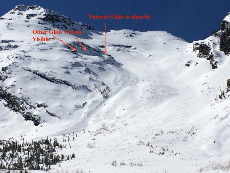
recent activity A great Ogden area observation:
A narrow, but long running glide avalanche was witnessed in Broads Fork, Big Cottonwood Canyon, at 10 am yesterday, with an observation posted HERE and 2 photos below (PC Greg Gagne). In addition, there were reports of a few shallow wind slabs triggered, and minor wet loose sluffs.
|
| type | aspect/elevation | characteristics |
|---|

|

|
LIKELIHOOD
 LIKELY
UNLIKELY
SIZE
 LARGE
SMALL
TREND
 INCREASING DANGER
SAME
DECREASING DANGER
|
|
description
Wet snow avalanches are once again the main concern, so it’s another good day for early starts and early finishes. Very warm temperatures and a mix of direct sun and high thin clouds will heat the snow on all but upper elevation, northerly facing slopes. While winds and afternoon clouds may help to prevent the snow from becoming too sloppy, the snow will heat up today and:
Travel advice: Get off of and out from below any steep slope when the snow becomes wet and sloppy. Especially avoid terrain traps like gullies where even a small slide could pile up debris deeply. |
| type | aspect/elevation | characteristics |
|---|

|

|
LIKELIHOOD
 LIKELY
UNLIKELY
SIZE
LARGE
SMALL
TREND
 INCREASING DANGER
SAME
DECREASING DANGER
|
|
description
Even with a generally LOW danger, avalanche concerns still exist, especially in upper elevation alpine terrain:
|
 |
weather The warm, southwest flow will continue over the area through most of Monday. Clear skies this morning will give way to high thin clouds by mid-day, and then thicker mid-level clouds by this afternoon. Temperatures will soar into the mid-40s at 8,000’ and the mid-30s along the high ridge lines. The currently light southwesterly winds will increase slightly today, with speeds along the high ridgelines reaching averages of 25 mph, with gusts into the 30s. The next cold front should arrive Monday evening, with snow lingering into Tuesday. Storm totals of 5 to 10 inches of snow are possible. For the rest of the week, it looks mostly dry, with temperatures once again becoming unseasonably warm through next weekend. |
| general announcements Remember your information can save lives. If you see anything we should know about, please participate in the creation of our own community avalanche advisory by submitting snow and avalanche conditions. You can also call us at 801-524-5304 or 800-662-4140, email by clicking HERE, or include #utavy in your tweet or Instagram. If you trigger an avalanche in the backcountry - especially if you are adjacent to a ski area – please call the following teams to alert them to the slide and whether anyone is missing or not. Rescue teams can be exposed to significant hazard when responding to avalanches, and do not want to do so when unneeded. Thanks. Salt Lake and Park City – Alta Central (801-742-2033), Canyons Resort Dispatch (435-615-3322) Snowbasin Resort Dispatch (801-620-1017), Powder Mountain Dispatch (801-745-3772 x 123). Sundance Dispatch (801-223-4150) EMAIL ADVISORY We have switched to a new SLC email advisory system. If you would like to get the daily advisory by email, or if you have been getting the advisory by email since the beginning of the season and wish to continue, you will need to subscribe here. DAWN PATROL Hotline updated daily by 5-530am - 888-999-4019 option 8. Twitter Updates for your mobile phone - DETAILS UDOT canyon closures: LINK TO UDOT Utah Avalanche Center mobile app - Get your advisory on your iPhone along with great navigation and rescue tools.uned. Wasatch Powderbird Guides Blog/Itinerary for the Day. Lost or Found something in the backcountry? - http://nolofo.com/ Discount lift tickets are now available at Backcountry.com - Thanks to Ski Utah and the Utah Resorts. All proceeds go towards paying for Utah Avalanche Center avalanche and mountain weather advisories. To those skinning uphill at resorts: it is your responsibility to know the resort policy on uphill travel. Some allow uphill travel and have guidelines, some don't. Contact the Ski Patrol at each resort for details. IMPORTANT: Before skinning at a resort under new snow conditions, check in with Ski Patrol. Resorts can restrict or cut off access if incompatible with control and grooming operations. Benefit the Utah Avalanche Center when you shop from Backcountry.com or REI: Click this link for Backcountry.com or this link to REI, shop, and they will donate a percent of your purchase price to the UAC. Both offer free shipping (with some conditions) so this costs you nothing! Benefit the Utah Avalanche Center when you buy or sell on ebay - set the Utah Avalanche Center as a favorite non-profit in your ebay account here and click on ebay gives when you buy or sell. You can choose to have your seller fees donated to the UAC, which doesn't cost you a penny. This information does not apply to developed ski areas or highways where avalanche control is normally done. This advisory is from the U.S.D.A. Forest Service, which is solely responsible for its content. This advisory describes general avalanche conditions and local variations always exist |


_4.jpg)