| During the month of April, Mark Miller will donate $75 to the charity of your choice (5 to chose from, including the Utah Avalanche Center!) Mark Miller Subaru has raised over $300k in the previous 6 Do Good Feel Good events. More Info here |  |
| During the month of April, Mark Miller will donate $75 to the charity of your choice (5 to chose from, including the Utah Avalanche Center!) Mark Miller Subaru has raised over $300k in the previous 6 Do Good Feel Good events. More Info here | |
| Advisory: Ogden Area Mountains | Issued by Drew Hardesty for Sunday - February 23, 2014 - 6:52am |
|---|

|
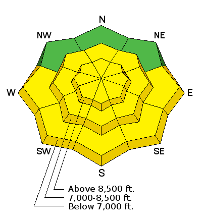
bottom line The danger for both human triggered and natural avalanches is MODERATE for shallow wind drifts and loose wet and dry sluffs in steeper terrain at the mid and upper elevations. These are high probability, low consequence unless in unforgiving terrain. Manageable avalanches for experienced backcountry travelers. A "scary" MODERATE exists for triggering a deeper slab avalanche in thin, steep, rocky terrain in predominantly northwest to east to southeast facing slopes above about 8000'. These are low probability, high consequence avalanches. Unmanageable avalanches for even the most experienced backcountry travelers.
|
 |
special announcement Due to the popularity and response from our first ever Snowshoe Backcountry 101 classes this year, we are running one more this next week. The evening session will be this Wednesday, February 26, with the field day at Brighton on Saturday March 1. Sign up here. |
 |
current conditions Skies are clear. Temperatures this morning are in the upper teens and low 20s. Winds are 15-20mph from the west and northwest but for the most exposed ridgelines where the anemometers keep pace at 35-40mph. The weak little wave from yesterday teased out a trace to two in most locations, with upwards of 6-8" as you move north into the Logan area mountains. Skiing and riding conditions are excellent in the sun and wind sheltered terrain. |
 |
recent activity No significant activity reported from the backcountry yesterday. |
| type | aspect/elevation | characteristics |
|---|

|
|
LIKELIHOOD
 LIKELY
UNLIKELY
SIZE
 LARGE
SMALL
TREND
 INCREASING DANGER
SAME
DECREASING DANGER
|
|
description
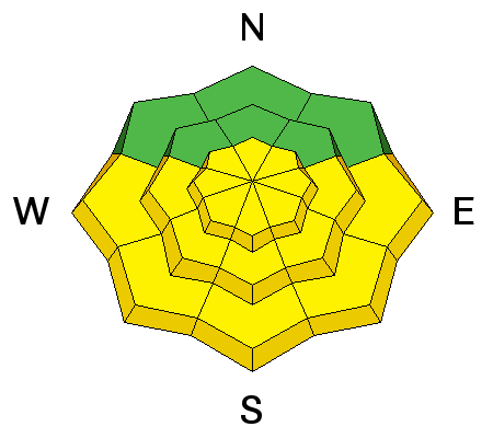
I've lumped both wet and dry into the Loose Snow category for expediency...as travel recommendations are similar. They'll be widespread along the east to south to west facing slopes of all elevations and in the upper elevation northerly terrain. Clear skies and daytime warming will initiate wet point release sluffs in the steepest sunlit terrain today. Skiers and riders should expect to also trigger both wet and dry sluffs in the steepest terrain that should only pose a problem if in very long steep sustained gullies and chutes or if traveling in or above "no-fall terrain". Sluff management techniques include skiing or riding fast across the fall-line from area of safety to area of safety, moving downhill and then laterally to allow the sluff to move by, and pulling up along a rib or spine to allow the loose snow to run past. They also respond to cornice fall as well. |
| type | aspect/elevation | characteristics |
|---|

|
|
LIKELIHOOD
LIKELY
UNLIKELY
SIZE
LARGE
SMALL
TREND
 INCREASING DANGER
SAME
DECREASING DANGER
|
|
description
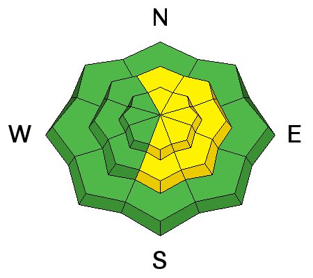
Sustained hourly averages into the 20s and 30s along the exposed ridgelines will provide plenty of sensitive, if shallow wind drifts along the lee of ridgelines, cross-loaded into the lee of spines and sub-ridges, and into many deceleration zones. They'll be most prominent in terrain with an easterly component. It's possible that the clear skies and high relative humidities have fostered the development of surface hoar and a touch of "recystallization' of the surface snow...and I'd plan for any new wind drift deposited on these to be sensitive and potentially triggered at a distance. |
| type | aspect/elevation | characteristics |
|---|

|
|
LIKELIHOOD
 LIKELY
UNLIKELY
SIZE
 LARGE
SMALL
TREND
 INCREASING DANGER
SAME
DECREASING DANGER
|
|
description
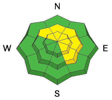
To the best of our knowledge, the last human triggered persistent/deep slab in the backcountry was on the 16th. Since then, there have been few reports of cracking and collapsing...or significant loading (beyond sustained wind in specific terrain). Poor structure has been well documented...though likelihood of triggering seems to have greatly diminished over the past week. Regions more prone would be along the periphery of the Cottonwoods, in shallower areas and in steep, rocky, unsupported terrain features. It's also likely that heavier loads may be needed to crowbar out one of these deeper slides such as more than one snowmobile on the slope, a large cornice drop, another slide from above that steps down, or explosives. Even though the color is yellow, these are all very different animals. To understand more - check out this older Blog Post. And so for these reasons, travel recommendations for deep slabs are completely different than the previous two avalanche problems - see for yourself. |
 |
weather Sunny skies will prevail with moderate west to northwest winds and temps reaching into the low to mid-30s at 8000' and the upper 20s at 10,000'. Look for a brush-by system to the north on Tuesday with a at-this-time good looking quick hitting storm for Thursday and a broader more potent storm for the weekend. |
| general announcements
Remember your information can save lives. If you see anything we should know about, please participate in the creation of our own community avalanche advisory by submitting snow and avalanche conditions. You can also call us at 801-524-5304 or 800-662-4140, email by clicking HERE, or include #utavy in your tweet or Instagram. If you trigger an avalanche in the backcountry - especially if you are adjacent to a ski area – please call the following teams to alert them to the slide and whether anyone is missing or not. Rescue teams can be exposed to significant hazard when responding to avalanches, and do not want to do so when unneeded. Thanks. Salt Lake and Park City – Alta Central (801-742-2033), Canyons Resort Dispatch (435-615-3322) Snowbasin Resort Dispatch (801-620-1017), Powder Mountain Dispatch (801-745-3772 x 123). Sundance Dispatch (801-223-4150) EMAIL ADVISORY We have switched to a new SLC email advisory system. If you would like to get the daily advisory by email, or if you have been getting the advisory by email since the beginning of the season and wish to continue, you will need to subscribe here. DAWN PATROL Hotline updated daily by 5-530am - 888-999-4019 option 8. Twitter Updates for your mobile phone - DETAILS UDOT canyon closures: LINK TO UDOT Utah Avalanche Center mobile app - Get your advisory on your iPhone along with great navigation and rescue tools.uned. Wasatch Powderbird Guides Blog/Itinerary for the Day. Lost or Found something in the backcountry? - http://nolofo.com/ Discount lift tickets are now available at Backcountry.com - Thanks to Ski Utah and the Utah Resorts. All proceeds go towards paying for Utah Avalanche Center avalanche and mountain weather advisories. To those skinning uphill at resorts: it is your responsibility to know the resort policy on uphill travel. Some allow uphill travel and have guidelines, some don't. Contact the Ski Patrol at each resort for details. IMPORTANT: Before skinning at a resort under new snow conditions, check in with Ski Patrol. Resorts can restrict or cut off access if incompatible with control and grooming operations. Benefit the Utah Avalanche Center when you shop from Backcountry.com or REI: Click this link for Backcountry.com or this link to REI, shop, and they will donate a percent of your purchase price to the UAC. Both offer free shipping (with some conditions) so this costs you nothing! Benefit the Utah Avalanche Center when you buy or sell on ebay - set the Utah Avalanche Center as a favorite non-profit in your ebay account here and click on ebay gives when you buy or sell. You can choose to have your seller fees donated to the UAC, which doesn't cost you a penny. This information does not apply to developed ski areas or highways where avalanche control is normally done. This advisory is from the U.S.D.A. Forest Service, which is solely responsible for its content. This advisory describes general avalanche conditions and local variations always exist. |


_4.jpg)