| During the month of April, Mark Miller will donate $75 to the charity of your choice (5 to chose from, including the Utah Avalanche Center!) Mark Miller Subaru has raised over $300k in the previous 6 Do Good Feel Good events. More Info here |  |
| During the month of April, Mark Miller will donate $75 to the charity of your choice (5 to chose from, including the Utah Avalanche Center!) Mark Miller Subaru has raised over $300k in the previous 6 Do Good Feel Good events. More Info here | |
| Advisory: Ogden Area Mountains | Issued by Evelyn Lees for Friday - February 14, 2014 - 7:27am |
|---|

|
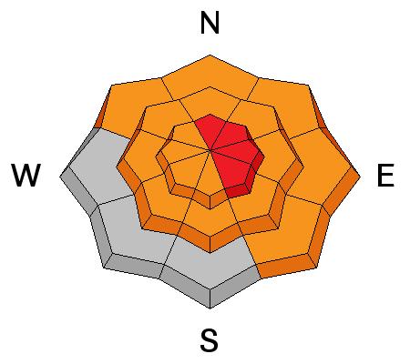
bottom line The avalanche danger is at least a CONSIDERABLE on all aspects and elevations on any slope approaching 35 degrees and steeper. Areas of HIGH DANGER exist on the north through easterly facing slopes above about 9500’, especially on and below slopes newly loaded with drifts of wind blown snow. Leaving the exit gates of one of the mountain resorts? You are stepping through that gate into CONSIDERABLE TO HIGH danger. Those without expert level avalanche skills, including terrain and snowpack evaluation, should avoid backcountry travel today and Saturday.
|
 |
avalanche warning AVALANCHE WARNING FOR THE LOGAN AREA MOUNTAINS, THE WESTERN UINTAS AND THE MANTI-SKYLINE. |
 |
avalanche watch AN AVALANCHE WATCH HAS BEEN ISSUED FOR THE OGDEN, SALT LAKE, PARK CITY AND PROVO AREA MOUNTAINS. DANGEROUS AVALANCHE CONDITIONS EXIST ON MOST ASPECTS AND ELEVATIONS. THE AVALANCHE DANGER IS EXPECTED TO INCREASE THROUGH SATURDAY WITH INCREASING WINDS AND WARMING TEMPERATURES. THOSE WITHOUT EXPERT LEVEL AVALANCHE SKILLS SHOULD AVOID BACKCOUNTRY TRAVEL. |
 |
special announcement Remember, there is safe world-class powder skiing to be had at the resorts right now. You can get donated discount lift tickets here [link to http://www.backcountry.com/Store/catalog/search.jsp?q=utah+avalanche+center&s=u] to benefit the Utah Avalanche Center. This might be a good time to mention that we also have 4 Alta discount lift tickets left over from the Black Diamond Fall Fundraising Party for sale - order here. [link to http://utahavalanchecenter.org/alta-lift-tickets]. Splitboarders: The Wasatch Splitfest will be held in SLC Feb 13-16, with daily tours and a party Saturday night at the Canyon Inn featuring a series of presentations, socializing, post-tour refreshments, and a drawing for great donated gear to benefit the Utah Avalanche Center. The recent tragedies in the backcountry underscore the importance of backcountry education and safety awareness and Forecaster Brett Kobernik will be giving a talk about what is going on in the snow right now. Details here [link to https://www.facebook.com/WasatchSplitfest?fref=ts] |
 |
current conditions Light snow is once again falling in the mountains this morning and temperatures will rival Sochi’s through Saturday. Another quick shot of snow yesterday afternoon has brought storm totals up to about a foot of snow and 1 ½” to 2” water in the Cottonwoods and Ogden area mountains, with about half those amounts elsewhere. Temperatures struggled to get below freezing at many elevations in the Ogden mountains last night, with reading in the mid 20s to low 30s common this morning. The northwesterly winds are temporarily light. The surface snow became wet and sloppy on all aspects up to about 8500’ yesterday, and this morning’s crusts will be short lived as it rapidly returns to the consistency of mashed potatoes with daytime heating. Remnants of dry snow remain on upper elevation, northerly facing slopes. |
 |
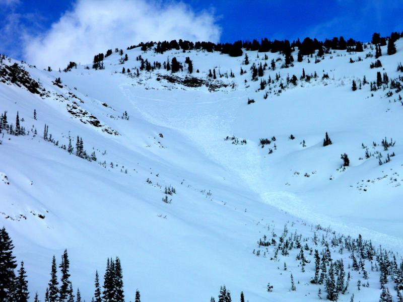
recent activity Resort and highway control work resulted in widespread releases of new snow soft slabs and winds slabs, including a deeper slide in Toledo Bowl – 2 to 4 feet deep and 380’ wide, failing on mid pack facets. (photo below)
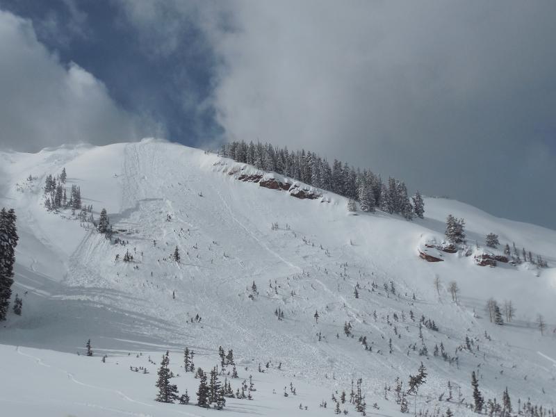
In Santaquin Canyon a snowmobile triggered a road bank, resulting in partial burial. A cornice fall in Dutch Draw triggered a mid-slope slide, failing on facets. (photo below)
There was also a small remotely triggered wind slab in Cardiff. |
| type | aspect/elevation | characteristics |
|---|

|
|
LIKELIHOOD
 LIKELY
UNLIKELY
SIZE
 LARGE
SMALL
TREND
 INCREASING DANGER
SAME
DECREASING DANGER
|
|
description
Increasingly sensitive wind drifts will be forming today as the westerly winds ramp up by late morning, with the high ridges averaging up to 40 mph. These new wind drifts will be very sensitive – natural avalanches will become possible, human triggered slides likely. Cornices will also be very sensitive, easy to trigger or breaking off spontaneously and further back than expected. |
| type | aspect/elevation | characteristics |
|---|

|
|
LIKELIHOOD
 LIKELY
UNLIKELY
SIZE
 LARGE
SMALL
TREND
INCREASING DANGER
SAME
DECREASING DANGER
|
|
description
These are the potential monsters – deep, wide avalanches breaking mid pack or near the ground are possible on many aspects of the mid and upper elevations, running far down the slope. These deep slides can be triggered by a person, or may occur naturally, with a smaller slide being the trigger. The weight of a sluff, wind slab or cornice moving down slope can trigger one of these deep, dangerous slides. These slides can be triggered remotely from a distance, including from below. |
| type | aspect/elevation | characteristics |
|---|

|
|
LIKELIHOOD
LIKELY
UNLIKELY
SIZE
LARGE
SMALL
TREND
INCREASING DANGER
SAME
DECREASING DANGER
|
|
description
The snow pack didn’t have much of a chance to cool overnight, and today’s warming temperatures and rain to 8,500’ will keep the snow wet and weak. The whole smorgasbord of wet snow avalanches are possible -
|
 |
weather A warm front will cross northern Utah today, bringing warming temperatures and increasingly strong westerly winds. 10,000’ highs will warm into the upper 20s, 8000’ temperatures will be in the mid-40s. The westerly winds should ramp up this morning, with most stations in the 15 to 25 mph averages, with gusts in the 40s by noon. The highest ridges and peaks could average 40 mph, with gusts to 70. Snowfall amounts of very dense snow should be minor today: 1-3” south of I-80, 3 to 5” north of I-80. Even warmer on Saturday, with high thin clouds, ahead of a quick moving cold front on Sunday, which will bring cooling temperatures and a quick shot of snow. |
| general announcements Remember your information can save lives. If you see anything we should know about, please participate in the creation of our own community avalanche advisory by submitting snow and avalanche conditions. You can also call us at 801-524-5304 or 800-662-4140, email by clicking HERE, or include #utavy in your tweet or Instagram. If you trigger an avalanche in the backcountry - especially if you are adjacent to a ski area – please call the following teams to alert them to the slide and whether anyone is missing or not. Rescue teams can be exposed to significant hazard when responding to avalanches, and do not want to do so when unneeded. Thanks. Salt Lake and Park City – Alta Central (801-742-2033), Canyons Resort Dispatch (435-615-3322) Snowbasin Resort Dispatch (801-620-1017), Powder Mountain Dispatch (801-745-3772 x 123). Sundance Dispatch (801-223-4150) EMAIL ADVISORY We have switched to a new SLC email advisory system. If you would like to get the daily advisory by email, or if you have been getting the advisory by email since the beginning of the season and wish to continue, you will need to subscribe here. DAWN PATROL Hotline updated daily by 5-530am - 888-999-4019 option 8. Twitter Updates for your mobile phone - DETAILS UDOT canyon closures: LINK TO UDOT Utah Avalanche Center mobile app - Get your advisory on your iPhone along with great navigation and rescue tools.uned. Wasatch Powderbird Guides Blog/Itinerary for the Day. Lost or Found something in the backcountry? - http://nolofo.com/ Discount lift tickets are now available at Backcountry.com - Thanks to Ski Utah and the Utah Resorts. All proceeds go towards paying for Utah Avalanche Center avalanche and mountain weather advisories. To those skinning uphill at resorts: it is your responsibility to know the resort policy on uphill travel. Some allow uphill travel and have guidelines, some don't. Contact the Ski Patrol at each resort for details. IMPORTANT: Before skinning at a resort under new snow conditions, check in with Ski Patrol. Resorts can restrict or cut off access if incompatible with control and grooming operations. Benefit the Utah Avalanche Center when you shop from Backcountry.com or REI: Click this link for Backcountry.com or this link to REI, shop, and they will donate a percent of your purchase price to the UAC. Both offer free shipping (with some conditions) so this costs you nothing! Benefit the Utah Avalanche Center when you buy or sell on ebay - set the Utah Avalanche Center as a favorite non-profit in your ebay account here and click on ebay gives when you buy or sell. You can choose to have your seller fees donated to the UAC, which doesn't cost you a penny. This information does not apply to developed ski areas or highways where avalanche control is normally done. This advisory is from the U.S.D.A. Forest Service, which is solely responsible for its content. This advisory describes general avalanche conditions and local variations always exist. |


_4.jpg)