| During the month of April, Mark Miller will donate $75 to the charity of your choice (5 to chose from, including the Utah Avalanche Center!) Mark Miller Subaru has raised over $300k in the previous 6 Do Good Feel Good events. More Info here |  |
| During the month of April, Mark Miller will donate $75 to the charity of your choice (5 to chose from, including the Utah Avalanche Center!) Mark Miller Subaru has raised over $300k in the previous 6 Do Good Feel Good events. More Info here | |
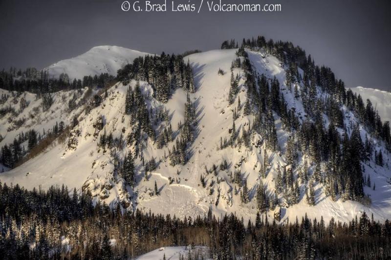
| Advisory: Ogden Area Mountains | Issued by Drew Hardesty for Thursday - February 13, 2014 - 7:20am |
|---|

|
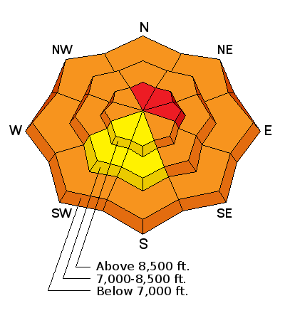
bottom line Most terrain has an overall CONSIDERABLE avalanche danger. Areas of HIGH danger exist in north through east facing terrain above about 8000'. Leaving the exit gates of one of the mountain resorts? You are stepping through that gate into CONSIDERABLE TO HIGH danger. Got your avalanche beacon, shovel, and probe? Good - but it's like wearing your seat belt with a head-on collision with an 18-wheeler. Avalanche danger exists on all aspects and elevations on any slope approaching 35 degrees and steeper. It may be possible to be in the flats and remotely trigger the 4-5' deep avalanche on top of you. Runout zones are to be avoided as well.
|
 |
avalanche warning For the Logan area mountains, SE Idaho, Western Uintas, and Manti-Skyline Plateau south to Interstate 70 - DANGEROUS AVALANCHE CONDITIONS EXIST ON ALL ASPECTS AND ELEVATIONS. AVOID BEING ON OR BENEATH STEEP TERRAIN...AS AVALANCHES MAY BE TRIGGERED FROM BELOW.
|
 |
special avalanche bulletin For the Ogden, Salt Lake, Park City, and Provo area mountains - THIS SPECIAL AVALANCHE ADVISORY IS FOR THE OGDEN, SALT LAKE, PARK CITY AND PROVO AREA MOUNTAINS. DANGEROUS AVALANCHE CONDITIONS EXIST ON MANY ASPECTS AND ELEVATIONS. THOSE WITHOUT EXPERT LEVEL AVALANCHE SKILLS SHOULD AVOID BACKCOUNTRY TRAVEL.
|
 |
special announcement Remember, there is safe world-class powder skiing to be had at the resorts right now. You can get donated discount lift tickets here [link to http://www.backcountry.com/Store/catalog/search.jsp?q=utah+avalanche+center&s=u] to benefit the Utah Avalanche Center. This might be a good time to mention that we also have 4 Alta discount lift tickets left over from the Black Diamond Fall Fundraising Party for sale - order here. [link to http://utahavalanchecenter.org/alta-lift-tickets]. Splitboarders: The Wasatch Splitfest will be held in SLC Feb 13-16, with daily tours and a party Saturday night at the Canyon Inn featuring a series of presentations, socializing, post-tour refreshments, and a drawing for great donated gear to benefit the Utah Avalanche Center. The recent tragedies in the backcountry underscore the importance of backcountry education and safety awareness and Forecaster Brett Kobernik will be giving a talk about what is going on in the snow right now. Details here [link to https://www.facebook.com/WasatchSplitfest?fref=ts] Bruce Tremper will be giving the finale of our Fireside Chats at the Black Diamond store tonight at 7:30. They're free, informal, and educational - and typically these are more high-end avalanche chats that cover current conditions and more. |
 |
current conditions And the atmospheric river continues to flow...most areas picked up another 2-4" overnight pushing new storm totals to about a 6-8" in Ogden, the Cottonwoods, Park City, and the Provo area mountains. Densities exceed 10% - far from cold smoke - but at this point we need the water in any way, shape or form. Rain/snow lines reported at 6500-7000'... Ben Lomond reports 4" and 1.3" snow-water-equivalent in the past 24 hours. Temperatures continue to rise and are in the upper 20s and low 30s. Winds, while gusty from the west yesterday, have calmed a bit and are now in the 15-20mph range along the exposed ridgelines. |
 |
recent activity Most prevalent activity from yesterday were scattered new natural and human triggered loose snow slides and wind drifts generally less than a foot deep or so...however, human triggered persistent slabs continue to be triggered every day - check the Ogden avalanches from the past few days on our Detailed Info/Avalanches page - Tuesday - Bonanza Flats/Mars Hill area - snowmobilers triggered a 4' deep and 100' wide hard slab on a steep ramp at 9800' in east facing terrain...failing on weak facets just beneath a rain/rime crust.
Yesterday - Lake Mary area in the Brighton perimeter - skiers/boarders triggered a 3' deep and 35' wide pocket on an unsupported slope at 9600' on east facing terrain. (photo Jim Harris)
|
| type | aspect/elevation | characteristics |
|---|

|

|
LIKELIHOOD
 LIKELY
UNLIKELY
SIZE
 LARGE
SMALL
TREND
 INCREASING DANGER
SAME
DECREASING DANGER
|
|
description
These persistent and deep slab avalanches are unpredictable, dangerous, and in many cases unsurvivable. 1/3-1/4 of all avalanche fatalities are due to trauma not burial - take note of the slide triggered in the Brighton periphery yesterday. Collapsing is also a sign of instability with our poor structure and - as distinct to most years - not limited to just north and east facing terrain. With remote triggering possible - even from below - it's dangerous to be walking underneath any steep path, great or small. Mid pack sensitivities well represented by Jake Hutchinson, below - ECTP24.SP.2.12.14 from Jake Hutchinson on Vimeo. |
| type | aspect/elevation | characteristics |
|---|

|

|
LIKELIHOOD
 LIKELY
UNLIKELY
SIZE
 LARGE
SMALL
TREND
INCREASING DANGER
SAME
DECREASING DANGER
|
|
description
Old and newly forming wind drifts may be triggered in steep drifted terrain along the lee of ridgelines and sub-ridges and may be up to 18-24" in heavily loaded terrain. Warming temps will help them stabilize, however keep an eye on the winds and continued obvious drifting today. These are most prevalent in areas with an easterly component... Cornices are also growing large and unmanageable. If you can't see the ridgeline/cornice - back off. These yawning cornices - now like hard slabs - have a tendency to break back much farther than you expect. Just ask the snowboarder along the PC ridgeline from two days ago. Remember that dropped cornices (and people falling over with them) put a good thump on the slope...and may be enough to trigger a significantly deeper slab below.
|
| type | aspect/elevation | characteristics |
|---|

|

|
LIKELIHOOD
LIKELY
UNLIKELY
SIZE
LARGE
SMALL
TREND
INCREASING DANGER
SAME
DECREASING DANGER
|
|
description
Rain on snow events typically produce at least wet loose avalanching and with enough percolation, produce wet slab avalanches into weak faceted snow. These may be tricky with fluctuating rain/snow lines...avoid terrain traps if you are in an area that is raining.... |
 |
weather We'll have continued off and on snowfall throughout the day and into tomorrow. Another 2-5" is possible accompanied by 20-25mph winds. Temps will be near 30 at 10,000' and the mid 30s at 8000'. Rapid warming and sun is on tap for Saturday with mountain temps likely in the 40s and 50s! - and the avalanche conditions will be accentuated by these temps/sun. A cold front follows for Sunday with colder storms on the way into next week. |
| general announcements
Remember your information can save lives. If you see anything we should know about, please participate in the creation of our own community avalanche advisory by submitting snow and avalanche conditions. You can also call us at 801-524-5304 or 800-662-4140, email by clicking HERE, or include #utavy in your tweet or Instagram. If you trigger an avalanche in the backcountry - especially if you are adjacent to a ski area – please call the following teams to alert them to the slide and whether anyone is missing or not. Rescue teams can be exposed to significant hazard when responding to avalanches, and do not want to do so when unneeded. Thanks. Salt Lake and Park City – Alta Central (801-742-2033), Canyons Resort Dispatch (435-615-3322) Snowbasin Resort Dispatch (801-620-1017), Powder Mountain Dispatch (801-745-3772 x 123). Sundance Dispatch (801-223-4150) EMAIL ADVISORY We have switched to a new SLC email advisory system. If you would like to get the daily advisory by email, or if you have been getting the advisory by email since the beginning of the season and wish to continue, you will need to subscribe here. DAWN PATROL Hotline updated daily by 5-530am - 888-999-4019 option 8. Twitter Updates for your mobile phone - DETAILS UDOT canyon closures: LINK TO UDOT Utah Avalanche Center mobile app - Get your advisory on your iPhone along with great navigation and rescue tools.uned. Wasatch Powderbird Guides Blog/Itinerary for the Day. Lost or Found something in the backcountry? - http://nolofo.com/ Discount lift tickets are now available at Backcountry.com - Thanks to Ski Utah and the Utah Resorts. All proceeds go towards paying for Utah Avalanche Center avalanche and mountain weather advisories. To those skinning uphill at resorts: it is your responsibility to know the resort policy on uphill travel. Some allow uphill travel and have guidelines, some don't. Contact the Ski Patrol at each resort for details. IMPORTANT: Before skinning at a resort under new snow conditions, check in with Ski Patrol. Resorts can restrict or cut off access if incompatible with control and grooming operations. Benefit the Utah Avalanche Center when you shop from Backcountry.com or REI: Click this link for Backcountry.com or this link to REI, shop, and they will donate a percent of your purchase price to the UAC. Both offer free shipping (with some conditions) so this costs you nothing! Benefit the Utah Avalanche Center when you buy or sell on ebay - set the Utah Avalanche Center as a favorite non-profit in your ebay account here and click on ebay gives when you buy or sell. You can choose to have your seller fees donated to the UAC, which doesn't cost you a penny. This information does not apply to developed ski areas or highways where avalanche control is normally done. This advisory is from the U.S.D.A. Forest Service, which is solely responsible for its content. This advisory describes general avalanche conditions and local variations always exist. |


_4.jpg)