
| During the month of April, Mark Miller will donate $75 to the charity of your choice (5 to chose from, including the Utah Avalanche Center!) Mark Miller Subaru has raised over $300k in the previous 6 Do Good Feel Good events. More Info here |  |
| During the month of April, Mark Miller will donate $75 to the charity of your choice (5 to chose from, including the Utah Avalanche Center!) Mark Miller Subaru has raised over $300k in the previous 6 Do Good Feel Good events. More Info here | |
| Advisory: Ogden Area Mountains | Issued by Brett Kobernik for Wednesday - February 12, 2014 - 7:19am |
|---|

|
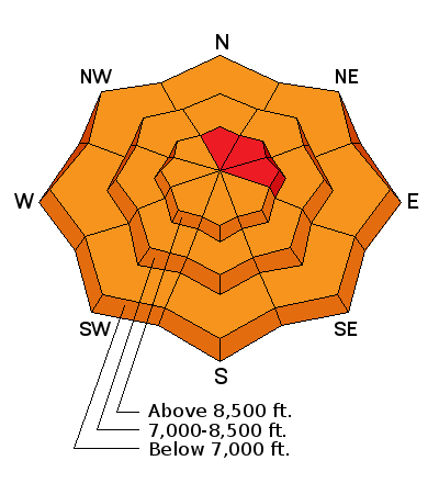
bottom line DANGEROUS AVALANCHE CONDITIONS REMAIN!! The avalanche danger will again be on the rise over the next couple of days. Human triggered avalanches are likely on many slopes and almost certain on steep upper elevation north through east facing slopes. The overall avalanche danger is CONSIDERABLE but areas of HIGH DANGER remain. Those without expert level avalanche skills are urged to avoid going into the mountains at this time.
|
 |
avalanche watch DEEP, DANGEROUS AND POTENTIALLY UNSURVIVABLE AVALANCHES ARE STILL BEING TRIGGERED BY PEOPLE AND THE DANGER WILL INCREASE DURING AND AFTER THE UPCOMING WET AND WINDY STORM WITH RISING TEMPERATURES. PEOPLE WITHOUT EXPERT LEVEL AVALANCHE TRAINING AND EXPERIENCE SHOULD AVOID BACKCOUNTRY TRAVEL OVER THE NEXT COUPLE OF DAYS. AVOID BEING ON AND BELOW ALL STEEP SLOPES AND WATCH FOR ROOFS TO AVALANCHE AS TEMPERATURES INCREASE. |
 |
current conditions Under partly cloudy skies temperatures are just slightly warmer this morning than they were yesterday morning. We had lows in the upper teens to around 20 degrees. Westerly winds bumped in speed slightly late yesterday afternoon but have slowed again as of now. |
 |
recent activity There were large human triggered avalanches breaking into old Also, a snowboarder had a cornice collapse under him and he tumbled onto a steep slope in Dutch's Draw. Luckily, the slope he landed on did not release and produce a larger more dangerous avalanche. DETAILS photo: Trent Meisenheimer |
| type | aspect/elevation | characteristics |
|---|

|
|
LIKELIHOOD
 LIKELY
UNLIKELY
SIZE
 LARGE
SMALL
TREND
 INCREASING DANGER
SAME
DECREASING DANGER
|
|
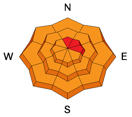
description
It's no time to split hairs with this avalanche threat. It is not wise to try and out smart persistent weak layers. You may not see any 'bullseye' red flags as noted in some observations. It is best to just 'chill' and let things take their course for a bit. Perhaps once this storm moves through and we go through some settlement we might see some improved stability but at this time it's unclear how this will shake out. We anticipate that the avalanche danger will increase over the next couple of days with more snow, wind and warming temperatures. |
| type | aspect/elevation | characteristics |
|---|

|
|
LIKELIHOOD
LIKELY
UNLIKELY
SIZE
 LARGE
SMALL
TREND
INCREASING DANGER
SAME
DECREASING DANGER
|
|
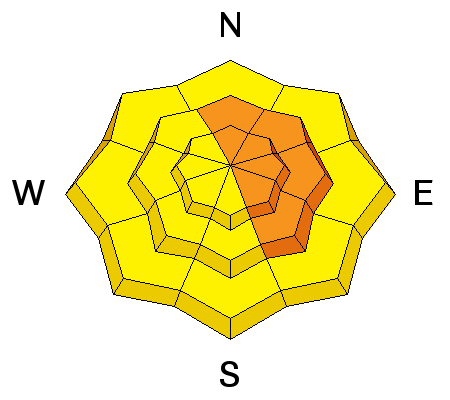
description
Avoid areas with both old and new wind slabs. These on their own may be sensitive but in many areas they will just compound the danger of the buried persistent weak layers by continuing to add more weight on top of the already poor snowpack structure. It's not the time to attempt to use mitigation techniques such as ski cuts. Even using small test slopes by sidehilling a snowmobile or jumping on them with snowshoes is not recommended right now unless they are the smallest and most benign slopes with no consequences if they avalanche. |
 |
weather We should see snow start later this afternoon with 2 to 4 inches of accumulation possible by this evening. Snow densities should be moderate to high. Temperatures will warm to near freezing at 8000 feet and into the mid 20s along the ridges. Rain/snow line should be around 7000 feet. Stiff westerly winds will increase during the day. Stiff westerly winds and periods of snow should continue tonight through Thursday with perhaps around a foot of snow total and around an inch of water give or take. 700mb temps go to +3C by Saturday. What this means is VERY warm temperatures as we move into the weekend. |
| general announcements Remember your information can save lives. If you see anything we should know about, please participate in the creation of our own community avalanche advisory by submitting snow and avalanche conditions. You can also call us at 801-524-5304 or 800-662-4140, email by clicking HERE, or include #utavy in your tweet or Instagram. If you trigger an avalanche in the backcountry - especially if you are adjacent to a ski area – please call the following teams to alert them to the slide and whether anyone is missing or not. Rescue teams can be exposed to significant hazard when responding to avalanches, and do not want to do so when unneeded. Thanks. Salt Lake and Park City – Alta Central (801-742-2033), Canyons Resort Dispatch (435-615-3322) Snowbasin Resort Dispatch (801-620-1017), Powder Mountain Dispatch (801-745-3772 x 123). Sundance Dispatch (801-223-4150) EMAIL ADVISORY We have switched to a new SLC email advisory system. If you would like to get the daily advisory by email, or if you have been getting the advisory by email since the beginning of the season and wish to continue, you will need to subscribe here. DAWN PATROL Hotline updated daily by 5-530am - 888-999-4019 option 8. Twitter Updates for your mobile phone - DETAILS UDOT canyon closures: LINK TO UDOT Utah Avalanche Center mobile app - Get your advisory on your iPhone along with great navigation and rescue tools.uned. Wasatch Powderbird Guides Blog/Itinerary for the Day. Lost or Found something in the backcountry? - http://nolofo.com/ Discount lift tickets are now available at Backcountry.com - Thanks to Ski Utah and the Utah Resorts. All proceeds go towards paying for Utah Avalanche Center avalanche and mountain weather advisories. To those skinning uphill at resorts: it is your responsibility to know the resort policy on uphill travel. Some allow uphill travel and have guidelines, some don't. Contact the Ski Patrol at each resort for details. IMPORTANT: Before skinning at a resort under new snow conditions, check in with Ski Patrol. Resorts can restrict or cut off access if incompatible with control and grooming operations. Benefit the Utah Avalanche Center when you shop from Backcountry.com or REI: Click this link for Backcountry.com or this link to REI, shop, and they will donate a percent of your purchase price to the UAC. Both offer free shipping (with some conditions) so this costs you nothing! Benefit the Utah Avalanche Center when you buy or sell on ebay - set the Utah Avalanche Center as a favorite non-profit in your ebay account here and click on ebay gives when you buy or sell. You can choose to have your seller fees donated to the UAC, which doesn't cost you a penny. This information does not apply to developed ski areas or highways where avalanche control is normally done. This advisory is from the U.S.D.A. Forest Service, which is solely responsible for its content. This advisory describes general avalanche conditions and local variations always exist. |


_4.jpg)
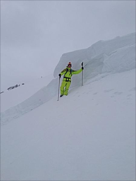 preexisting weak snow in all regions from the Manti Skyline, Western Uintas through the Central Wasatch to Logan yesterday. Here in the Wasatch, two separate groups of skiers came together on a ridgeline in Mineral Fork of Big Cottonwood and the combined weight was enough to initiate a collapse and trigger a very large avalanche from a distance. They were in a safe location on a flat section of a ridge and the avalanche released and ran down a steep slope below them.