
| During the month of April, Mark Miller will donate $75 to the charity of your choice (5 to chose from, including the Utah Avalanche Center!) Mark Miller Subaru has raised over $300k in the previous 6 Do Good Feel Good events. More Info here |  |
| During the month of April, Mark Miller will donate $75 to the charity of your choice (5 to chose from, including the Utah Avalanche Center!) Mark Miller Subaru has raised over $300k in the previous 6 Do Good Feel Good events. More Info here | |
| Advisory: Ogden Area Mountains | Issued by Brett Kobernik for Thursday - February 6, 2014 - 7:17am |
|---|


|
bottom line The avalanche danger starts out MODERATE this morning and will be on the rise through the weekend. Keep a close eye on any wind drifted snow today. The wind may drift enough snow to make the avalanche danger CONSIDERABLE later today. Buried persistent weak layers of snow may collapse under the weight of a person today especially in shallow snowpack areas. Any wind loading in these areas will enhance the persistent slab avalanche concern. ANTICIPATE RISING AVALANCHE DANGER THROUGH THE WEEKEND.
|
 |
avalanche watch THIS AVALANCHE WATCH IS FOR ALL THE MOUNTAINS OF NORTHERN UTAH, WESTERN UINTAS AND THE WASATCH PLATEAU. A WINTER STORM WITH AN EXTENDED PERIOD OF SNOWFALL, INTENSIFYING WEST WIND, AND GRADUALLY WARMING TEMPERATURES WILL OVERLOAD EXISTING WEAK LAYERS OF SNOW. THIS WILL CREATE DANGEROUS AVALANCHE CONDITIONS IN THE BACKCOUNTRY. DRIFTING SNOW WILL CAUSE THE AVALANCHE DANGER TO RISE THROUGHOUT TODAY AND OVERNIGHT. DANGEROUS AVALANCHE CONDITIONS WILL LIKELY DEVELOP BY FRIDAY AND LAST THROUGH THE WEEKEND. |
 |
current conditions Winds have bumped up in speed slightly since Wednesday and are in the moderate speed category from the west along the mid elevation ridges. They're gusting to 50 along the highest locations. Temperatures are mostly in the mid teens. Riding conditions remain excellent. There's been light snowfall noted in a few locations this morning. |
 |
recent activity No avalanches were reported in the Ogden area mountains but there were a number of human triggered avalanches on Wednesday in the Salt Lake region. It appears that some may have involved older weak faceted snow. Two skiers were caught and carried and ended up uninjured on north facing Mt Superior. One snowboarder was caught, carried, and uninjured on a west facing slope in White Pine of Little Cottonwood. A snowboarder remotely triggered a small slab avalanche in Porter Fork and one more human triggered avalanche was reported from Little Water Peak.
It seems a number of us have gotten a little too complacent over the last week or so with the snowpack not really growling at us too much even with the addition of a good amount of snow. This is very easy to do and I try hard to not let this happen to myself. Here is a quote from one of the people who was caught yesterday: 'I started to get the impression that everything was safe as I have seen no signs the past two weeks'. Thanks for that Scott, you're not the only one. |
| type | aspect/elevation | characteristics |
|---|

|
|
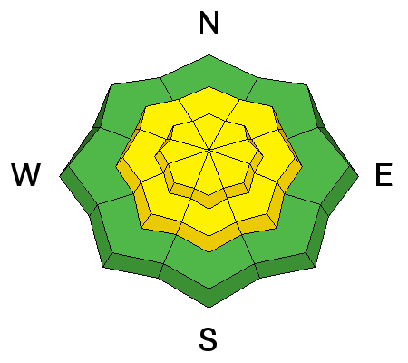
LIKELIHOOD
 LIKELY
UNLIKELY
SIZE
 LARGE
SMALL
TREND
 INCREASING DANGER
SAME
DECREASING DANGER
|
|
description
With the bump in wind speeds, you'll note that the rose for this problem covers more area today than yesterday. While northwest through east facing slopes are the most likely places for a wind slab to form, they can form around terrain features on all aspects due to variability in how the wind is channeled through the terrain. You should note that the likelihood of triggering one of these is higher than yesterday as well. Pay close attention to any visible drifting. Watch for large 'pillowy' looking areas of snow. Keep an eye out for any cracking as you travel around. |
| type | aspect/elevation | characteristics |
|---|

|
|
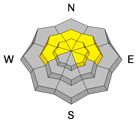
LIKELIHOOD
 LIKELY
UNLIKELY
SIZE
LARGE
SMALL
TREND
INCREASING DANGER
SAME
DECREASING DANGER
|
|
description
The persistent avalanche problem should still be considered today and will no doubt demand our attention as the snow and wind move in Friday. If the storm holds together as it looks like it may, the buried persistent faceted weak layers are almost sure to come to life and produce dangerous avalanche conditions this weekend. Weak layers include old facets from November and December as well as more recent issues revolving around a couple of rain crusts. |
 |
weather We'll have snow showers today perhaps accumulating a few inches of snow by late this afternoon. Winds will be from the west southwest in the moderate speed category with strong speeds along the highest terrain. Temperatures will be in the teens. Snowfall continues Friday. Temperatures warm a bit more on Friday with continued southwest winds before things really ramp up late Friday into Saturday. Winds become stronger and snowfall intensifies. Temperatures continue to warm with snow densities and snow levels rising. Snow should continue into Monday with a few periods of more intense snowfall during that time. If the storm holds together, this could be a significant snow and avalanche event for the mountains. Water totals could be 1.5 to 3.5 inches with around two feet of snow or more. |
| general announcements Remember your information can save lives. If you see anything we should know about, please participate in the creation of our own community avalanche advisory by submitting snow and avalanche conditions. You can also call us at 801-524-5304 or 800-662-4140, email by clicking HERE, or include #utavy in your tweet or Instagram. If you trigger an avalanche in the backcountry - especially if you are adjacent to a ski area – please call the following teams to alert them to the slide and whether anyone is missing or not. Rescue teams can be exposed to significant hazard when responding to avalanches, and do not want to do so when unneeded. Thanks. Salt Lake and Park City – Alta Central (801-742-2033), Canyons Resort Dispatch (435-615-3322) Snowbasin Resort Dispatch (801-620-1017), Powder Mountain Dispatch (801-745-3772 x 123). Sundance Dispatch (801-223-4150) EMAIL ADVISORY We have switched to a new SLC email advisory system. If you would like to get the daily advisory by email, or if you have been getting the advisory by email since the beginning of the season and wish to continue, you will need to subscribe here. DAWN PATROL Hotline updated daily by 5-530am - 888-999-4019 option 8. Twitter Updates for your mobile phone - DETAILS UDOT canyon closures: LINK TO UDOT Utah Avalanche Center mobile app - Get your advisory on your iPhone along with great navigation and rescue tools.uned. Wasatch Powderbird Guides Blog/Itinerary for the Day. Lost or Found something in the backcountry? - http://nolofo.com/ Discount lift tickets are now available at Backcountry.com - Thanks to Ski Utah and the Utah Resorts. All proceeds go towards paying for Utah Avalanche Center avalanche and mountain weather advisories. To those skinning uphill at resorts: it is your responsibility to know the resort policy on uphill travel. Some allow uphill travel and have guidelines, some don't. Contact the Ski Patrol at each resort for details. IMPORTANT: Before skinning at a resort under new snow conditions, check in with Ski Patrol. Resorts can restrict or cut off access if incompatible with control and grooming operations. Benefit the Utah Avalanche Center when you shop from Backcountry.com or REI: Click this link for Backcountry.com or this link to REI, shop, and they will donate a percent of your purchase price to the UAC. Both offer free shipping (with some conditions) so this costs you nothing! Benefit the Utah Avalanche Center when you buy or sell on ebay - set the Utah Avalanche Center as a favorite non-profit in your ebay account here and click on ebay gives when you buy or sell. You can choose to have your seller fees donated to the UAC, which doesn't cost you a penny. This information does not apply to developed ski areas or highways where avalanche control is normally done. This advisory is from the U.S.D.A. Forest Service, which is solely responsible for its content. This advisory describes general avalanche conditions and local variations always exist. |


_4.jpg)