| During the month of April, Mark Miller will donate $75 to the charity of your choice (5 to chose from, including the Utah Avalanche Center!) Mark Miller Subaru has raised over $300k in the previous 6 Do Good Feel Good events. More Info here |  |
| During the month of April, Mark Miller will donate $75 to the charity of your choice (5 to chose from, including the Utah Avalanche Center!) Mark Miller Subaru has raised over $300k in the previous 6 Do Good Feel Good events. More Info here | |
| Advisory: Ogden Area Mountains | Issued by Drew Hardesty for Wednesday - January 29, 2014 - 7:05am |
|---|

|
bottom line The danger will rise dramatically over the next several days. The danger will rise to MODERATE today for
....with the overall danger rising toward CONSIDERABLE by tonight and perhaps HIGH by tomorrow. Mind the AVALANCHE WATCH for today...we may be in AVALANCHE WARNING criteria for tomorrow -
|
 |
avalanche watch THIS AVALANCHE WATCH IS FOR ALL THE MOUNTAINS OF NORTHERN AND CENTRAL UTAH, TO INCLUDE THE WESTERN UINTA MOUNTAINS...AND AS FAR SOUTH AS THE FISHLAKE PLATEAU AND ALONG THE I-70 CORRIDOR. EXPECTED HEAVY SNOWFALL AND STRONG WINDS WILL CREATE DANGEROUS AVALANCHE CONDITIONS THROUGH THE REST OF THE WEEK AND INTO THE WEEKEND. |
 |
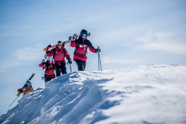
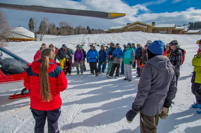
special announcement We have a custom UAC graphic Chimera Unicorn Chaser splitboard, a pair of donated BD 165 cm Element skis, and Fritschi Diamir Explore bindings, all new, all donated, for sale on Ebay. Great way to get a great deal and support a great cause. Big Thanks to Chimera, Black Diamond, and a private donor. CLICK HERE TO VIEW THE DETAILS - AUCTION ENDS TOMORROW AT 11AM!!! Huge thanks to Snowbasin and all the amazing athletes for bringing the stoke and hosting this year's FreeRide Avalanche Workshop. Strong work by our own Craig Gordon, Trent Meisenheimer and others!
Freeride 1- Snowbasin patrol leads the charge up the ridge for this years FreeRide Workshop Freeride 2- Freeride athletes learn how to work around an air ambulance |
 |
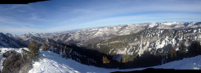
current conditions A powerful winter storm is on the doorstep. (I know most of you looked up at the date stamp to see if it was April Fools...but afraid not). What looks to be a wet, warm and windy event is rapidly approaching and we're already seeing radar echoes in the Logan area and north of the Great Salt Lake. More in the weather forecast below, but suffice it to say, this is like water to a dying man. Skies are overcast, temps have been on the rise overnight and are in the 20s (and still warming), and winds are blowing from the west at 35-40mph, gusting to 50. These wind speeds seem exclusive to the most exposed anemometers. Snow surface conditions have been fair at best - one can ride through wind, temperature, and rime crusts - not to mention other tracks - all within the span of a few hundred feet. And that's in places that actually have snow. View below from the Benson/Reed ridgeline looking north.
This is gonna get interesting. |
 |
recent activity No activity of note but for some shallow wind slabs pried out with explosives in the Provo area mountains and some facet sluffing in steep terrain along the Park City ridgeline. |
| type | aspect/elevation | characteristics |
|---|

|

|
LIKELIHOOD
 LIKELY
UNLIKELY
SIZE
 LARGE
SMALL
TREND
 INCREASING DANGER
SAME
DECREASING DANGER
|
|
description
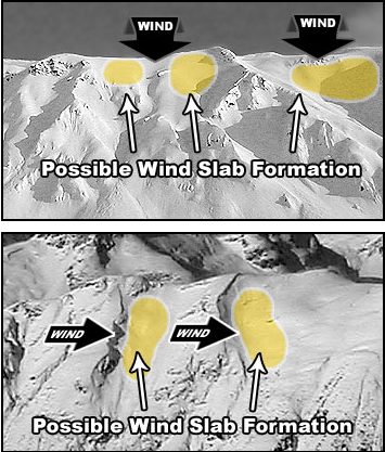
While I expect the warm new snow to bond fairly well to the warm, predominantly rough corrugated old snow surfaces, wind drifts are a different situation altogether. There is not a great deal of old snow to blow around, but that which remains - along with whatever comes out of the sky today - will be easily transported by expected westerly ridgetop winds of 30-50mph winds (highest averages pencilled in for the most exposed ridges and those along 11,000'.) Shallow new wind drifts will load quickly and more extensively by the afternoon and will be found predominantly on steep north through east through south facing terrain...with emphasis on areas with an easterly component... Be suspect of
|
| type | aspect/elevation | characteristics |
|---|

|

|
LIKELIHOOD
LIKELY
UNLIKELY
SIZE
LARGE
SMALL
TREND
INCREASING DANGER
SAME
DECREASING DANGER
|
|
description
What - A rising rain-snow line to perhaps 8500' by this afternoon/evening will create unstable snow at the lower elevations. Wet loose sluffs and rollerballs - both natural and human triggered will become more likely as rain develops and at all elevations up to the rain/snow line. Where - It's the snow in the shady cold areas that are most likely to sluff - northwest through north through northeasterly facing terrain as well as steep-walled gullies - Avoid being in and underneath steep terrain traps such as Cutler Creek, Black Canyon, Malan's and the other terrain near North Ogden Divide (as an example). WARNING - many of the ice climbing routes are in classic avalanche runout zones and are prone to flushing with wet debris. We suffered one such fatality in January 1997 in Provo Canyon. |
| type | aspect/elevation | characteristics |
|---|

|

|
LIKELIHOOD
 LIKELY
UNLIKELY
SIZE
 LARGE
SMALL
TREND
INCREASING DANGER
SAME
DECREASING DANGER
|
|
description
The persistent/deep slab dragon is mostly dormant but would expect it to roar to life once again if snow forecast totals of 12-18" verifies. By tomorrow, avoidance of this suspect terrain - northwest through east above 8000' will again be key and guilty until proven innocent. |
 |
weather Should be a wild 48 hours. Precipitation should begin at any moment with a rising rain/snow line to perhaps 8500' by late afternoon. Winds will increase in ferocity over the course of the day with the westerlies reaching hourly averages of 40-50mph and gusts to 75 by the afternoon, if not earlier. Temps will rise to 30 degrees at 10,000' and the mid to upper 30s at 8000'. There is a tremendous amount of moisture associated with this system - and while snow numbers may not be that impressive, the water numbers will be (or are likely to be). I'd expect 3-5" soggy inches today before the cold front arrives tonight where I suspect things really get going. I would anticipate 12-18" of snow for the event through late Thursday with upwards of 2" of precipitation for areas like Ben Lomond in the Ogden area mountains and the upper reaches of Big Cottonwood canyon. |
| general announcements
Remember your information can save lives. If you see anything we should know about, please participate in the creation of our own community avalanche advisory by submitting snow and avalanche conditions. You can also call us at 801-524-5304 or 800-662-4140, email by clicking HERE, or include #utavy in your tweet or Instagram. If you trigger an avalanche in the backcountry - especially if you are adjacent to a ski area – please call the following teams to alert them to the slide and whether anyone is missing or not. Rescue teams can be exposed to significant hazard when responding to avalanches, and do not want to do so when unneeded. Thanks. Salt Lake and Park City – Alta Central (801-742-2033), Canyons Resort Dispatch (435-615-3322) Snowbasin Resort Dispatch (801-620-1017), Powder Mountain Dispatch (801-745-3772 x 123). Sundance Dispatch (801-223-4150) EMAIL ADVISORY We have switched to a new SLC email advisory system. If you would like to get the daily advisory by email, or if you have been getting the advisory by email since the beginning of the season and wish to continue, you will need to subscribe here. DAWN PATROL Hotline updated daily by 5-530am - 888-999-4019 option 8. Twitter Updates for your mobile phone - DETAILS UDOT canyon closures: LINK TO UDOT Utah Avalanche Center mobile app - Get your advisory on your iPhone along with great navigation and rescue tools.uned. Wasatch Powderbird Guides Blog/Itinerary for the Day. Lost or Found something in the backcountry? - http://nolofo.com/ Discount lift tickets are now available at Backcountry.com - Thanks to Ski Utah and the Utah Resorts. All proceeds go towards paying for Utah Avalanche Center avalanche and mountain weather advisories. To those skinning uphill at resorts: it is your responsibility to know the resort policy on uphill travel. Some allow uphill travel and have guidelines, some don't. Contact the Ski Patrol at each resort for details. IMPORTANT: Before skinning at a resort under new snow conditions, check in with Ski Patrol. Resorts can restrict or cut off access if incompatible with control and grooming operations. Benefit the Utah Avalanche Center when you shop from Backcountry.com or REI: Click this link for Backcountry.com or this link to REI, shop, and they will donate a percent of your purchase price to the UAC. Both offer free shipping (with some conditions) so this costs you nothing! Benefit the Utah Avalanche Center when you buy or sell on ebay - set the Utah Avalanche Center as a favorite non-profit in your ebay account here and click on ebay gives when you buy or sell. You can choose to have your seller fees donated to the UAC, which doesn't cost you a penny. This information does not apply to developed ski areas or highways where avalanche control is normally done. This advisory is from the U.S.D.A. Forest Service, which is solely responsible for its content. This advisory describes general avalanche conditions and local variations always exist. |


_4.jpg)