
| During the month of April, Mark Miller will donate $75 to the charity of your choice (5 to chose from, including the Utah Avalanche Center!) Mark Miller Subaru has raised over $300k in the previous 6 Do Good Feel Good events. More Info here |  |
| During the month of April, Mark Miller will donate $75 to the charity of your choice (5 to chose from, including the Utah Avalanche Center!) Mark Miller Subaru has raised over $300k in the previous 6 Do Good Feel Good events. More Info here | |
| Advisory: Ogden Area Mountains | Issued by Brett Kobernik for Tuesday - January 28, 2014 - 7:08am |
|---|

|
bottom line The avalanche danger is generally LOW, with Pockets of MODERATE danger on steep, upper elevation slopes, facing north through east. On these slopes, human triggered avalanches are possible. With the upcoming storm, anticipate a rising avalanche danger through the end of the week.
|
 |
special announcement We have a custom UAC graphic Chimera Unicorn Chaser splitboard, a pair of donated BD 165 cm Element skis, and Fritschi Diamir Explore bindings, all new, all donated, for sale on Ebay. Great way to get a great deal and support a great cause. Big Thanks to Chimera, Black Diamond, and a private donor. CLICK HERE TO VIEW THE DETAILS |
 |
current conditions Westerly winds have slowed down and temperatures have dropped into the low to mid teens. The snow surface remains variable from place to place with wind crusts, sun crusts and some soft recrystalized snow if you hunt around in the most sheltered locations. |
| type | aspect/elevation | characteristics |
|---|

|

|
LIKELIHOOD
 LIKELY
UNLIKELY
SIZE
 LARGE
SMALL
TREND
 INCREASING DANGER
SAME
DECREASING DANGER
|
|
description
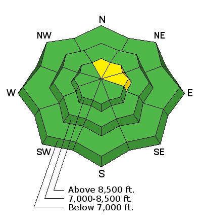
There is still an isolated chance that a person could trigger a slab avalanche. The most likely spots are along the lee sides of upper ridges that have had wind deposited snow. With the abundance of weak snow around, it is likely that many of these wind slabs are sitting on faceted snow that may collapse under the weight of a person. The persistent slab avalanche danger will most likely increase over the next few days as a moist and windy storm moves through. |
| type | aspect/elevation | characteristics |
|---|

|
|
LIKELIHOOD
LIKELY
UNLIKELY
SIZE
 LARGE
SMALL
TREND
 INCREASING DANGER
SAME
DECREASING DANGER
|
|
description
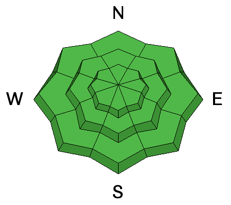
Out of the radical terrain, the snowpack is generally stable, but even with a mostly low danger, human triggered slides are still possible in isolated areas. Use normal caution, with the following considerations:
|
 |
weather Temperatures will rebound today from last nights fairly cool readings. Highs should get into the mid to upper 20s at 8000 feet and low 20s along the ridges. Northwest winds will be in the moderate speed range along the ridges. Slightly gusty along the ridges is what I anticipate. It does look like a storm will impact our area starting Wednesday and lingering into the weekend. It looks warm and windy to start then perhaps cooling Thursday. Weather models advertise a healthy amount of water with this storm which could translate to a foot of snow or better by the end of the week. |
| general announcements Remember your information can save lives. If you see anything we should know about, please participate in the creation of our own community avalanche advisory by submitting snow and avalanche conditions. You can also call us at 801-524-5304 or 800-662-4140, email by clicking HERE, or include #utavy in your tweet or Instagram. If you trigger an avalanche in the backcountry - especially if you are adjacent to a ski area – please call the following teams to alert them to the slide and whether anyone is missing or not. Rescue teams can be exposed to significant hazard when responding to avalanches, and do not want to do so when unneeded. Thanks. Salt Lake and Park City – Alta Central (801-742-2033), Canyons Resort Dispatch (435-615-3322) Snowbasin Resort Dispatch (801-620-1017), Powder Mountain Dispatch (801-745-3772 x 123). Sundance Dispatch (801-223-4150) EMAIL ADVISORY We have switched to a new SLC email advisory system. If you would like to get the daily advisory by email, or if you have been getting the advisory by email since the beginning of the season and wish to continue, you will need to subscribe here. DAWN PATROL Hotline updated daily by 5-530am - 888-999-4019 option 8. Twitter Updates for your mobile phone - DETAILS UDOT canyon closures: LINK TO UDOT Utah Avalanche Center mobile app - Get your advisory on your iPhone along with great navigation and rescue tools.uned. Wasatch Powderbird Guides Blog/Itinerary for the Day. Lost or Found something in the backcountry? - http://nolofo.com/ Discount lift tickets are now available at Backcountry.com - Thanks to Ski Utah and the Utah Resorts. All proceeds go towards paying for Utah Avalanche Center avalanche and mountain weather advisories. To those skinning uphill at resorts: it is your responsibility to know the resort policy on uphill travel. Some allow uphill travel and have guidelines, some don't. Contact the Ski Patrol at each resort for details. IMPORTANT: Before skinning at a resort under new snow conditions, check in with Ski Patrol. Resorts can restrict or cut off access if incompatible with control and grooming operations. Benefit the Utah Avalanche Center when you shop from Backcountry.com or REI: Click this link for Backcountry.com or this link to REI, shop, and they will donate a percent of your purchase price to the UAC. Both offer free shipping (with some conditions) so this costs you nothing! Benefit the Utah Avalanche Center when you buy or sell on ebay - set the Utah Avalanche Center as a favorite non-profit in your ebay account here and click on ebay gives when you buy or sell. You can choose to have your seller fees donated to the UAC, which doesn't cost you a penny. This information does not apply to developed ski areas or highways where avalanche control is normally done. This advisory is from the U.S.D.A. Forest Service, which is solely responsible for its content. This advisory describes general avalanche conditions and local variations always exist.
|


_4.jpg)