| During the month of April, Mark Miller will donate $75 to the charity of your choice (5 to chose from, including the Utah Avalanche Center!) Mark Miller Subaru has raised over $300k in the previous 6 Do Good Feel Good events. More Info here |  |
| During the month of April, Mark Miller will donate $75 to the charity of your choice (5 to chose from, including the Utah Avalanche Center!) Mark Miller Subaru has raised over $300k in the previous 6 Do Good Feel Good events. More Info here | |
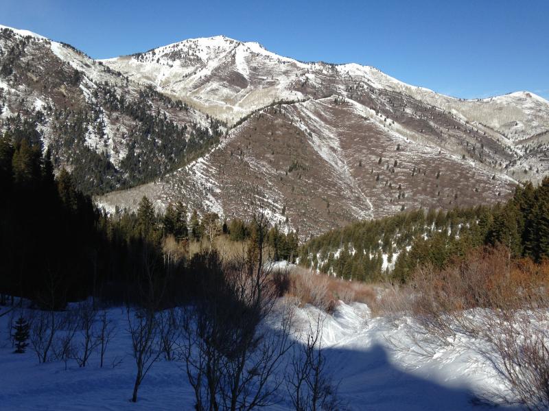
| Advisory: Ogden Area Mountains | Issued by Evelyn Lees for Friday - January 24, 2014 - 6:53am |
|---|

|
bottom line The avalanche danger is generally LOW, with pockets of MODERATE on upper elevation slopes facing northwest through east. On these slopes, the concern is triggering a slab avalanche. Avoiding terrain steeper than about 35 degrees will reduce your chance of triggering a slide. If you are traveling further afield, the avalanche danger is significantly higher in the Logan, western Uintas and Manti Skyline area mountains, so check out their specific forecasts.
|
 |
special announcement
FOCUS GROUP PARTICIPANTS NEEDED! We are trying to learn more about sidecountry riding and need your help. If you are between 17 – 30 years old, sometimes use lifts to get into the backcountry, and have little or no formal avalanche training, we want you to be a part of a focus group in SLC Feb 4. This will help us learn how to make avalanche education more relevant to you and those you ride with. We'll have FREE SKULLCANDY GEAR and pizza for all who join us for 2 hours. Hit us up if you think you fit the bill, at [email protected]. PLEASE SHARE THIS with people you think might fit that description. |
 |
current conditions Under clear skies, mid and upper elevation temperatures are about 10 degrees warmer than yesterday morning, mostly in the 20s. However, there are a few teens down in the basement, along the creeks and the canyon bottoms. The winds are just shifting back to the northwest, and very light, less than 10 mph. The high ridge lines of the Ogden mountains had about 12 hours of significant easterly winds yesterday, with speeds in the 30s, 40s and 50s. Some cold, soft snow remains on mid and upper elevation northerly facing slopes, and while mostly supportable, in shallow areas it crumbles to the touch like a dried out sandcastle. The extensive frozen crusts on the sunny slopes will be slow to soften, or “corn up”, today, with steeper south and west facing slopes your best bet. Looking at the dry, south facing slopes of Big Cottonwood.
|
 |
recent activity No backcountry avalanche activity reported from the forecast area in the past few days. |
| type | aspect/elevation | characteristics |
|---|

|
|
LIKELIHOOD
 LIKELY
UNLIKELY
SIZE
 LARGE
SMALL
TREND
 INCREASING DANGER
SAME
DECREASING DANGER
|
|
description
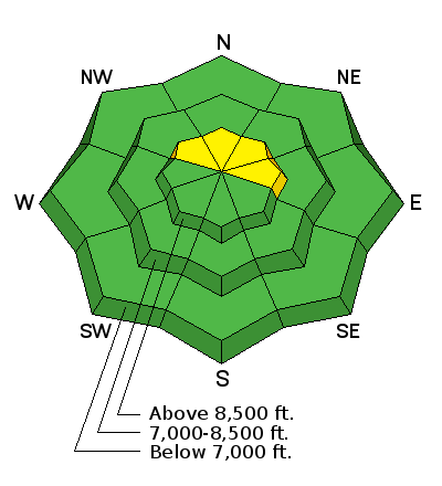
There are only isolated places where a person could trigger one of these deep slab avalanches – think steep, upper elevation terrain, on slopes facing northwest through east. Avoid the steepest portions of the slope and thinner snowpack areas, such as a rocky spot or a steeper break over. Have a cautious approach to aggressive terrain, and think defensively, with an escape route planned and by trying avoided the line with the worst consequences. |
| type | aspect/elevation | characteristics |
|---|

|

|
LIKELIHOOD
LIKELY
UNLIKELY
SIZE
 LARGE
SMALL
TREND
 INCREASING DANGER
SAME
DECREASING DANGER
|
|
description
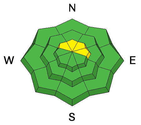
The snowpack is generally stable, but even with a low danger, human triggered slides are still possible in isolated areas. Use normal caution, with the following considerations:
|
 |
weather The mind-numbing high pressure continues – it will be another clear, sunny day with temperatures warming into the low 30s at 8000’ and in the upper 20s at 10,000’. The northwesterly winds will be very light, with gusts rarely above 20 mph, even along the highest ridgelines. The next chance for snow still looks to be about a week away. |
| general announcements This information does not apply to developed ski areas or highways where avalanche control is normally done. This advisory is from the U.S.D.A. Forest Service, which is solely responsible for its content. This advisory describes general avalanche conditions and local variations always exist. If you trigger an avalanche in the backcountry - especially if you are adjacent to a ski area – please call the following teams to alert them to the slide and whether anyone is missing or not. Rescue teams can be exposed to significant hazard when responding to avalanches, and do not want to do so when unneeded. Thanks. Salt Lake and Park City – Alta Central (801-742-2033), Canyons Resort Dispatch (435-615-3322) Snowbasin Resort Dispatch (801-620-1017), Powder Mountain Dispatch (801-745-3772 x 123). Sundance Dispatch (801-223-4150) EMAIL ADVISORY We have switched to a new SLC email advisory system. If you would like to get the daily advisory by email, or if you have been getting the advisory by email since the beginning of the season and wish to continue, you will need to subscribe here. DAWN PATROL Hotline updated daily by 5-530am - 888-999-4019 option 8. Twitter Updates for your mobile phone - DETAILS UDOT canyon closures: LINK TO UDOT Utah Avalanche Center mobile app - Get your advisory on your iPhone along with great navigation and rescue tools.uned. Wasatch Powderbird Guides Blog/Itinerary for the Day. Lost or Found something in the backcountry? - http://nolofo.com/ Discount lift tickets are now available at Backcountry.com - Thanks to Ski Utah and the Utah Resorts. All proceeds go towards paying for Utah Avalanche Center avalanche and mountain weather advisories. To those skinning uphill at resorts: it is your responsibility to know the resort policy on uphill travel. Some allow uphill travel and have guidelines, some don't. Contact the Ski Patrol at each resort for details. IMPORTANT: Before skinning at a resort under new snow conditions, check in with Ski Patrol. Resorts can restrict or cut off access if incompatible with control and grooming operations. Benefit the Utah Avalanche Center when you shop from Backcountry.com or REI: Click this link for Backcountry.com or this link to REI, shop, and they will donate a percent of your purchase price to the UAC. Both offer free shipping (with some conditions) so this costs you nothing! Benefit the Utah Avalanche Center when you buy or sell on ebay - set the Utah Avalanche Center as a favorite non-profit in your ebay account here and click on ebay gives when you buy or sell. You can choose to have your seller fees donated to the UAC, which doesn't cost you a penny. Remember your information can save lives. If you see anything we should know about, please participate in the creation of our own community avalanche advisory by submitting snow and avalanche conditions. You can also call us at 801-524-5304 or 800-662-4140, email by clicking HERE, or include #utavy in your tweet or Instagram. |


_4.jpg)