| During the month of April, Mark Miller will donate $75 to the charity of your choice (5 to chose from, including the Utah Avalanche Center!) Mark Miller Subaru has raised over $300k in the previous 6 Do Good Feel Good events. More Info here |  |
| During the month of April, Mark Miller will donate $75 to the charity of your choice (5 to chose from, including the Utah Avalanche Center!) Mark Miller Subaru has raised over $300k in the previous 6 Do Good Feel Good events. More Info here | |
| Advisory: Ogden Area Mountains | Issued by Drew Hardesty for Saturday - January 18, 2014 - 7:12am |
|---|

|
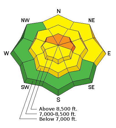
bottom line Most areas have a MODERATE avalanche danger. Areas of CONSIDERABLE danger exist in localized terrain within the northwest through east facing slopes above about 8000'. While natural avalanches are unlikely, human triggered slides, even remotely triggered slides, are possible, pulling out 1-3' deep or more and a couple hundred feet wide. Wet avalanche activity will rise toward MODERATE with daytime heating on the steep sunlit slopes. Diving in to steep northwest to east facing terrain? Be good to make sure your partners will be quick to Switch To Receive. The smart and savvy backcountry traveler will look for mid-elevation sheltered terrain well less than 35 degrees in steepness with nothing steeper above.
|
 |
special announcement The Snowbasin Freeride Avalanche Workshop will be held Jan 26-28. This is an avalanche & mountain safety skills workshop for freeride skiers & snowboarders riding & filming big lines. Details and Registration here. Brought to you by the Utah Avalanche Center, Snowbasin, Salomon, Atomic, & Suunto. We are switching to a new SLC email advisory system. If you would like to get the daily advisory by email, or if you have been getting the advisory by email since the beginning of the season and wish to continue, you will need to subscribe here. |
 |
current conditions Skies are clear, northwesterly winds are less than 15mph, temps are in the mid-20s. Riding conditions are pretty good - sure there are a few areas of wind and sun damage, but otherwise, things are holding up nicely. With direct sun and daytime warming, the southerly aspects are softening for a smooth ride home. Before heading out today, pause...just for a moment. Check out our latest blog post - I Just Can't Help Myself... |
 |
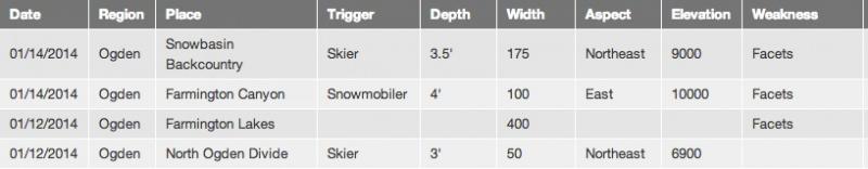
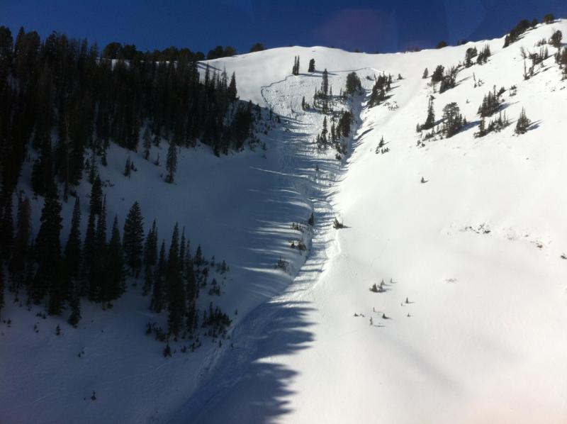
recent activity List of recent avalanche activity below - note these on easterly aspects that likely were heavily wind loaded. The North Ogden Divide avalanche - noteworthy b/c of its low elevation suggests a weak snowpack exists down low as well...though this terrain funnels wind and was overloaded by the westerly wind event.
A couple items of interest from SLC and Provo - (name-link takes you to the wbskiing.com map location).
|
| type | aspect/elevation | characteristics |
|---|

|
|
LIKELIHOOD
 LIKELY
UNLIKELY
SIZE
 LARGE
SMALL
TREND
 INCREASING DANGER
SAME
DECREASING DANGER
|
|
description
Likelihood is slowly decreasing, size is unchanged. It's still possible for a person to collapse the December/January slab into the November facets. In many areas where the overall snowpack is generally 3' or less, the early Nov/late Nov facets have become distinguishable only in size and shape and it's arguable - as it's a Persistent Slab here and a Deep Slab there...but in reality the travel recommendations are the same - Unmanageable avalanche conditions because of dangerous consequences and high uncertainty. These are best managed through avoidance. Standard stability tests work poorly such as test slopes, slope cuts, previous tracks, cornice drops and snow profiles. Typically confined to particular aspects and elevations (as depicted in the current avalanche forecast). Avoid this terrain or choose slopes gentler than 30 degrees in steepness including locally-connected terrain. Remote triggering possible, even from the valley below. Give runout zones a wide berth. If caught, these avalanches are difficult to survive. For more on our Draft Travel Recommendations for each Avalanche Problem, click here - |
| type | aspect/elevation | characteristics |
|---|

|
|
LIKELIHOOD
LIKELY
UNLIKELY
SIZE
 LARGE
SMALL
TREND
 INCREASING DANGER
SAME
DECREASING DANGER
|
|
description
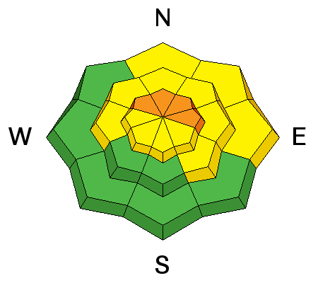
Be off of the steep sunlit aspects after they start to become soft and unsupportable. A few days of this weather has allowed for a healthy melt-freeze cycle; the trick is to not over-stay your welcome during the melt-phase. If you start to see roller-balls, pin-wheels or some wet loose activity, it's time to change aspects or head for the car. Some wet activity may gouge down into our more structured facet/crust snowpack, creating a more dangerous scenario. An outlier, but thin, structured snowpacks on the southerly aspects may pose a problem at some point this winter/spring. |
 |
weather Grim. High pressure will increase its stranglehold on the intermountain west through the end of the month. The Euro-model depicts a little rogue storm moving through late Thursday while the GFS sends it way, way south through Mexico. Temps will rise to the low to mid-30s at 10,000' and about 10 degrees warmer at 8000'. Winds'll remain generally light from the northwest. |
| general announcements
This information does not apply to developed ski areas or highways where avalanche control is normally done. This advisory is from the U.S.D.A. Forest Service, which is solely responsible for its content. This advisory describes general avalanche conditions and local variations always occur. If you trigger an avalanche in the backcountry - especially if you are adjacent to a ski area – please call the following teams to alert them to the slide and whether anyone is missing or not. Rescue teams can be exposed to significant hazard when responding to avalanches, and do not want to do so when unneeded. Thanks. Salt Lake and Park City – Alta Central (801-742-2033), Canyons Resort Dispatch (435-615-3322) Snowbasin Resort Dispatch (801-620-1017), Powder Mountain Dispatch (801-745-3772 x 123). Sundance Dispatch (801-223-4150) EMAIL ADVISORY Get the Salt Lake avalanche advisory emailed to you every morning. CLICK HERE FOR DETAILS DAWN PATROL Hotline updated daily by 5-530am - 888-999-4019 option 8. Twitter Updates for your mobile phone - DETAILS UDOT canyon closures: LINK TO UDOT Utah Avalanche Center mobile app - Get your advisory on your iPhone along with great navigation and rescue tools.uned. Wasatch Powderbird Guides Blog/Itinerary for the Day. Lost or Found something in the backcountry? - http://nolofo.com/ Discount lift tickets are now available at Backcountry.com - Thanks to Ski Utah and the Utah Resorts. All proceeds go towards paying for Utah Avalanche Center avalanche and mountain weather advisories. To those skinning uphill at resorts: it is your responsibility to know the resort policy on uphill travel. Some allow uphill travel and have guidelines, some don't. Contact the Ski Patrol at each resort for details. IMPORTANT: Before skinning at a resort under new snow conditions, check in with Ski Patrol. Resorts can restrict or cut off access if incompatible with control and grooming operations. Benefit the Utah Avalanche Center when you shop from Backcountry.com or REI: Click this link for Backcountry.com or this link to REI, shop, and they will donate a percent of your purchase price to the UAC. Both offer free shipping (with some conditions) so this costs you nothing! Benefit the Utah Avalanche Center when you buy or sell on ebay - set the Utah Avalanche Center as a favorite non-profit in your ebay account here and click on ebay gives when you buy or sell. You can choose to have your seller fees donated to the UAC, which doesn't cost you a penny. Remember your information can save lives. If you see anything we should know about, please participate in the creation of our own community avalanche advisory by submitting snow and avalanche conditions. You can also call us at 801-524-5304 or 800-662-4140, email by clicking HERE, or include #utavy in your tweet or Instagram. |


_4.jpg)