| During the month of April, Mark Miller will donate $75 to the charity of your choice (5 to chose from, including the Utah Avalanche Center!) Mark Miller Subaru has raised over $300k in the previous 6 Do Good Feel Good events. More Info here |  |
| During the month of April, Mark Miller will donate $75 to the charity of your choice (5 to chose from, including the Utah Avalanche Center!) Mark Miller Subaru has raised over $300k in the previous 6 Do Good Feel Good events. More Info here | |
| Advisory: Ogden Area Mountains | Issued by Bruce Tremper for Thursday - January 16, 2014 - 7:12am |
|---|

|
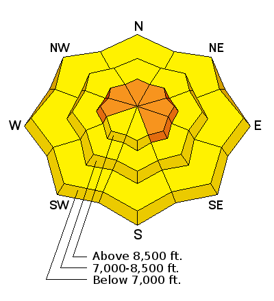
bottom line The avalanche danger remains at Level 3 (CONSIDERABLE) – large avalanches are possible in specific terrain. Although the probability of triggering an avalanche is small, if you do, the avalanche will be very large, deep and difficult to survive. This deep slab problem is most pronounced on northwest through north through easterly facing slopes, above about 9,500. The avalanche danger for wet slides will rise to MODERATE on and below steep sunny slopes as the day heats up. Even on the more dangerous aspects, you can always find much safer terrain on slopes less steep than about 33 degrees, not directly below or connected to the side of a steeper slope.
|
 |
avalanche warning An avalanche warning remains in effect for the western Uinta Mountains and the Logan area mountains. |
 |
special announcement The Snowbasin Freeride Avalanche Workshop will be held Jan 26-28. This is an avalanche & mountain safety skills workshop for freeride skiers & snowboarders riding & filming big lines. Details and Registration here. Brought to you by the Utah Avalanche Center, Snowbasin, Salomon, Atomic, & Suunto We are switching to a new SLC email advisory system. If you would like to get the daily advisory by email, or if you have been getting the advisory by email since the beginning of the season and wish to continue, you will need to subscribe here. |
 |
current conditions With a big, fat, full moon in the sky this morning, the weather remains clear with the overnight lows around 20 and the daytime highs near freezing. Ridge top wind is moderate from the west, northwest. There is still lots of soft, dense, recrystallized snow and surface hoar on the northerly-facing, shady slopes with plenty of sun crusts on south facing and some wind-damaged snow near the ridges. |
 |
recent activity We did not hear about any avalanches triggered in the backcountry of the Wasatch Range yesterday but three different resort were still able to trigger large, deep avalanches with explosives, going 3-6 feet deep and 100 or more feet wide including one at Snowbasin. One other controlled avalanche occurred in the western Uinta Mountains. These are the classic, low probability - high consequence avalanches.
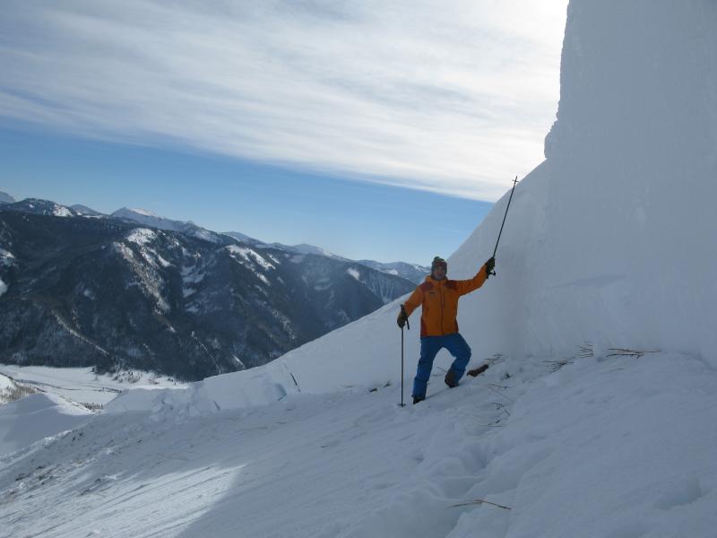
Explosive-triggered, deep slab in Weber Canyon of the western Uinta Mountains. This is similar to other explosive-triggered slides produced in the Wasatch Range yesterday. Check out the VIDEO. While you're at it, here are a couple great videos from the very close calls in the Logan area mountains from Sunday and Monday: KSL interview with snowmobiler survivors near the Utah-Idaho border Utah Avalanche Center forecasters investigate the huge avalanche on Logan Peak.
|
| type | aspect/elevation | characteristics |
|---|

|
|
LIKELIHOOD
 LIKELY
UNLIKELY
SIZE
 LARGE
SMALL
TREND
 INCREASING DANGER
SAME
DECREASING DANGER
|
|
description
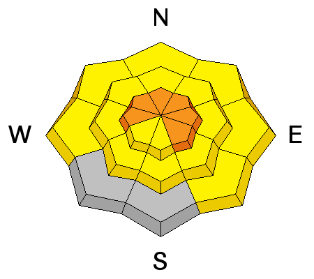
It's just one of those years. Three different ski resorts in the Wasatch Range triggered large, deep slabs with explosives yesterday, so the potential for large, deep, very dangerous avalanches continues. These are the classic, hard-to-trigger avalanches but if you do, they will be very large and very difficult to survive. The good news is that the Wasatch Range seems more stable than the Logan and western Uinta Mountains where there has been much more widespread avalanche activity from the last storm with several very close calls. The Wasatch Range seems to have a deeper, and more stable, snowpack than outside the Wasatch in the historically thinner snowpack areas. Most areas have a Level 2 (Moderate) danger but a Level 3 (Considerable) danger remains on the upper elevation shady aspects especially on slopes with wind deposits from the high winds over the weekend, which reactivated the deeply buried layers of depth hoar and faceted snow deep in the snowpack. |
| type | aspect/elevation | characteristics |
|---|

|
|
LIKELIHOOD
LIKELY
UNLIKELY
SIZE
 LARGE
SMALL
TREND
 INCREASING DANGER
SAME
DECREASING DANGER
|
|
description
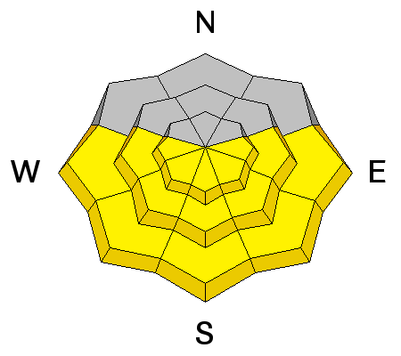
Most of the wet avalanche activity likely occurred over the past couple days, but temperatures will continue to warm as the high pressure builds in and we may see a few more roller balls and wet, loose sluffs today. |
 |
weather The forecast will likely lull you to sleep over the next couple weeks. Clear and warm up above the inversion layer in the valleys. Daytime highs should be just above freezing with overnight lows around 20 degrees. Ridge top winds will be moderate from the northwest 10 mph, gusting to 20. Unfortunately, we don't see any storms or snow as far as the eye can see--at least 10 days in our case. Zzzzzzz. |
| general announcements This information does not apply to developed ski areas or highways where avalanche control is normally done. This advisory is from the U.S.D.A. Forest Service, which is solely responsible for its content. This advisory describes general avalanche conditions and local variations always occur. If you trigger an avalanche in the backcountry - especially if you are adjacent to a ski area – please call the following teams to alert them to the slide and whether anyone is missing or not. Rescue teams can be exposed to significant hazard when responding to avalanches, and do not want to do so when unneeded. Thanks. Salt Lake and Park City – Alta Central (801-742-2033), Canyons Resort Dispatch (435-615-3322) Snowbasin Resort Dispatch (801-620-1017), Powder Mountain Dispatch (801-745-3772 x 123). Sundance Dispatch (801-223-4150) EMAIL ADVISORY Get the Salt Lake avalanche advisory emailed to you every morning. CLICK HERE FOR DETAILS DAWN PATROL Hotline updated daily by 5-530am - 888-999-4019 option 8. Twitter Updates for your mobile phone - DETAILS UDOT canyon closures: LINK TO UDOT Utah Avalanche Center mobile app - Get your advisory on your iPhone along with great navigation and rescue tools.uned. Wasatch Powderbird Guides Blog/Itinerary for the Day. They'll be up and running later this winter - Lost or Found something in the backcountry? - http://nolofo.com/ Discount lift tickets are now available at Backcountry.com - Thanks to Ski Utah and the Utah Resorts. All proceeds go towards paying for Utah Avalanche Center avalanche and mountain weather advisories. To those skinning uphill at resorts: it is your responsibility to know the resort policy on uphill travel. Some allow uphill travel and have guidelines, some don't. Contact the Ski Patrol at each resort for details. IMPORTANT: Before skinning at a resort under new snow conditions, check in with Ski Patrol. Resorts can restrict or cut off access if incompatible with control and grooming operations. Benefit the Utah Avalanche Center when you shop from Backcountry.com or REI: Click this link for Backcountry.com or this link to REI, shop, and they will donate a percent of your purchase price to the UAC. Both offer free shipping (with some conditions) so this costs you nothing! Benefit the Utah Avalanche Center when you buy or sell on ebay - set the Utah Avalanche Center as a favorite non-profit in your ebay account here and click on ebay gives when you buy or sell. You can choose to have your seller fees donated to the UAC, which doesn't cost you a penny. Remember your information can save lives. If you see anything we should know about, please participate in the creation of our own community avalanche advisory by submitting snow and avalanche conditions. You can also call us at 801-524-5304 or 800-662-4140, email by clicking HERE, or include #utavy in your tweet or Instagram. Ski Utah mobile snow updates: |


_4.jpg)