| During the month of April, Mark Miller will donate $75 to the charity of your choice (5 to chose from, including the Utah Avalanche Center!) Mark Miller Subaru has raised over $300k in the previous 6 Do Good Feel Good events. More Info here |  |
| During the month of April, Mark Miller will donate $75 to the charity of your choice (5 to chose from, including the Utah Avalanche Center!) Mark Miller Subaru has raised over $300k in the previous 6 Do Good Feel Good events. More Info here | |
| Advisory: Ogden Area Mountains | Issued by Bruce Tremper for Monday - January 6, 2014 - 6:59am |
|---|

|
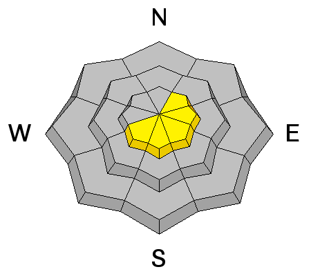
bottom line There is an overall Level 2 (MODERATE) (Yellow) avalanche danger today. Be cautious of steep slopes with recent wind deposits, which will usually look smooth and rounded. Also, fresh cornices may be sensitive along the upper elevation ridge lines. Never approach a drop off along a ridge without either first checking it out from safe angle or wearing a belay rope.
|
 |
special announcement I will give a Science of Avalanches talk tomorrow night, Tuesday, January 7th at 6:00 pm in Ogden at Gear:30. |
 |
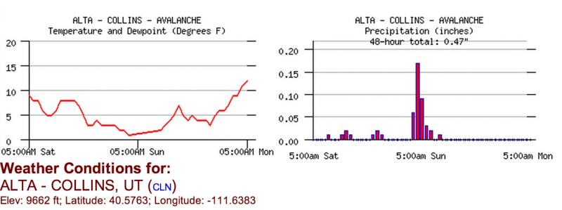
current conditions It's amazing how much 4 inches of low density, new snow can improve our grim conditions. Riding conditions are quite good (for a year like this). You can still feel the extremely variable, old snow surface beneath, which is soft, faceted snow on the shady aspects, sun crusts on the sunny aspects and old wind slabs in the upper elevation, wind exposed terrain. It was mighty chilly yesterday with temperatures just above zero and a stiff wind from the northwest--good training conditions for the Midwest right now. But temperatures have warmed 10 degrees since yesterday and they are now in the lower teens.
This is a 2-day chart for Alta Collins weather station. The present time is on the right side of each graph. |
 |
recent activity We did not hear about any significant activity from either the backcountry or the resorts on Sunday. The only report of note was a natural, cornice fall in the Monitors along the Park City ridge line. It occurred when the strong northwest wind built fresh, soft cornices along the ridge and a small piece broke off and created a small slide within the new snow below it. Parts of it gouged down into old faceted snow but did not create a slab. |
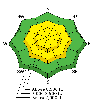
| type | aspect/elevation | characteristics |
|---|

|
|
LIKELIHOOD
 LIKELY
UNLIKELY
SIZE
 LARGE
SMALL
TREND
 INCREASING DANGER
SAME
DECREASING DANGER
|
|
description
The stiff wind from the northwest over the past couple days blew the 4 inches of low density, new snow into soft, shallow drifts in localized areas. Some of these cracked under the weight of a person but most remained soft and relatively benign. These wind slabs represent a relatively minor problem in most areas, but as usual, be cautious of steep slopes with recent wind deposits, which look smooth and rounded. Tutorial of wind slabs from the Encyclopedia. Click on Wind Slab.
|
| type | aspect/elevation | characteristics |
|---|

|
|
LIKELIHOOD
LIKELY
UNLIKELY
SIZE
LARGE
SMALL
TREND
INCREASING DANGER
SAME
DECREASING DANGER
|
|
description
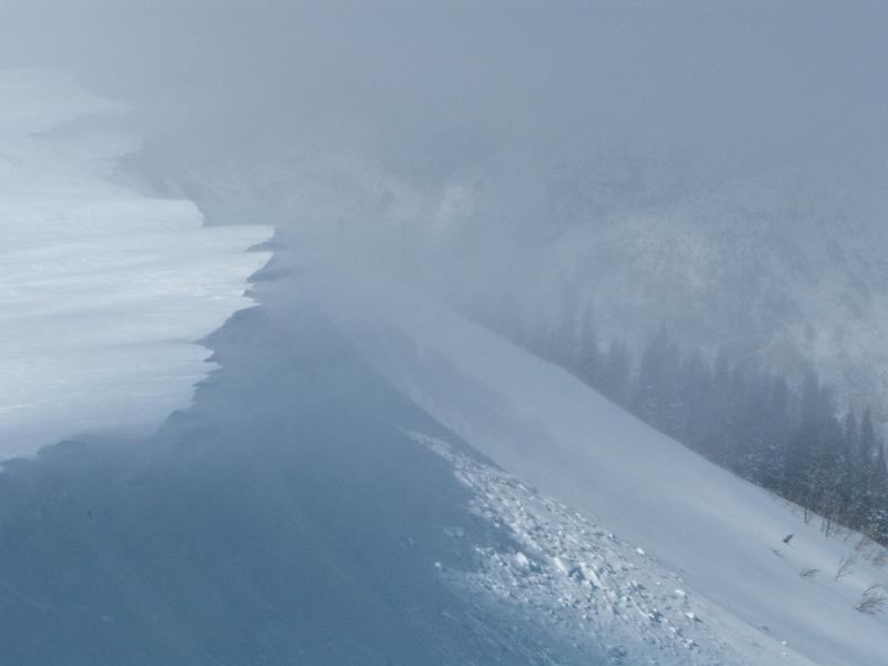
You may find some soft, sensitive, fresh cornices along the upper elevation ridges. As usual, never approach a drop off on a ridge without first checking it out from another angle or wearing a belay rope.
Example of a fresh, soft cornice from new snow and wind. |
 |
weather Temperatures will continue to warm today. The day time high should climb from the single digits and low teens this morning up to near freezing at 8,000'. Skies should remain clear. Ridge top winds should continue to blow 20, gusting to 30 from the northwest but they should slowly decrease throughout the day. We will have temperatures near freezing again on Tuesday with some increasing high clouds. The extended forecast calls for several weak, weather impulses Wednesday through the weekend. At this time, they will probably not produce much significant snow. The strongest and windiest of these will arrive this weekend, which may be enough to bring some increased avalanche danger. Stay tuned. |
| general announcements This information does not apply to developed ski areas or highways where avalanche control is normally done. This advisory is from the U.S.D.A. Forest Service, which is solely responsible for its content. This advisory describes general avalanche conditions and local variations always occur. If you trigger an avalanche in the backcountry - especially if you are adjacent to a ski area – please call the following teams to alert them to the slide and whether anyone is missing or not. Rescue teams can be exposed to significant hazard when responding to avalanches, and do not want to do so when unneeded. Thanks. Salt Lake and Park City – Alta Central (801-742-2033), Canyons Resort Dispatch (435-615-3322) Snowbasin Resort Dispatch (801-620-1017), Powder Mountain Dispatch (801-745-3772 x 123). Sundance Dispatch (801-231-4150) EMAIL ADVISORY Get the Salt Lake avalanche advisory emailed to you every morning. CLICK HERE FOR DETAILS DAWN PATROL Hotline updated daily by 5-530am - 888-999-4019 option 8. Twitter Updates for your mobile phone - DETAILS UDOT canyon closures: LINK TO UDOT Utah Avalanche Center mobile app - Get your advisory on your iPhone along with great navigation and rescue tools.uned. Wasatch Powderbird Guides Blog/Itinerary for the Day. They'll be up and running later this winter - Lost or Found something in the backcountry? - http://nolofo.com/ Discount lift tickets are now available at Backcountry.com - Thanks to Ski Utah and the Utah Resorts. All proceeds go towards paying for Utah Avalanche Center avalanche and mountain weather advisories. To those skinning uphill at resorts: it is your responsibility to know the resort policy on uphill travel. Some allow uphill travel and have guidelines, some don't. Contact the Ski Patrol at each resort for details. IMPORTANT: Before skinning at a resort under new snow conditions, check in with Ski Patrol. Resorts can restrict or cut off access if incompatible with control and grooming operations. Benefit the Utah Avalanche Center when you shop from Backcountry.com or REI: Click this link for Backcountry.com or this link to REI, shop, and they will donate a percent of your purchase price to the UAC. Both offer free shipping (with some conditions) so this costs you nothing! Benefit the Utah Avalanche Center when you buy or sell on ebay - set the Utah Avalanche Center as a favorite non-profit in your ebay account here and click on ebay gives when you buy or sell. You can choose to have your seller fees donated to the UAC, which doesn't cost you a penny. Remember your information can save lives. If you see anything we should know about, please participate in the creation of our own community avalanche advisory by submitting snow and avalanche conditions. You can also call us at 801-524-5304 or 800-662-4140, email by clicking HERE, or include #utavy in your tweet or Instagram. Ski Utah mobile snow updates: |


_4.jpg)