
| During the month of April, Mark Miller will donate $75 to the charity of your choice (5 to chose from, including the Utah Avalanche Center!) Mark Miller Subaru has raised over $300k in the previous 6 Do Good Feel Good events. More Info here |  |
| During the month of April, Mark Miller will donate $75 to the charity of your choice (5 to chose from, including the Utah Avalanche Center!) Mark Miller Subaru has raised over $300k in the previous 6 Do Good Feel Good events. More Info here | |
| Advisory: Ogden Area Mountains | Issued by Evelyn Lees for Wednesday - January 1, 2014 - 7:05am |
|---|


|
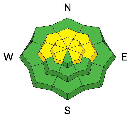
bottom line The avalanche danger is MODERATE on mid and upper elevation, west through north through easterly facing slopes. Large avalanche are possible in isolated areas (Danger Scale). The chance of triggering a slide is not high, but the consequences if you get caught are – a deep slide, breaking out near the ground. Avoiding travel on steep slopes facing west through north through east avoids most of the problem slopes. Wind drifts will be more wide spread today, and should be avoided on all steep slopes. A triggered wind drift has the potential to release a deeper, larger slide.
|
 |
special announcement The Utah Avalanche Center along with the Montana State University Ski Tracks project combines GPS technology with detailed logbook surveys completed by participants to help us understand how and why decisions are made in the winter backcountry. Participants will use a free smartphone app to record and send us their ski routes then, they will complete a simple online survey telling us some of the features of their tour. For more information visit: www.montana.edu/snowscience/tracks |
 |
current conditions
A little nano-storm slipped through northern Utah late yesterday, dropping a trace to an inch of snow. In its wake, it is a blustery start to the New Year, with northwesterly winds in the 20 to 25 mph range, and gusting to the 30’s. Wind speeds are significantly higher in the upper elevation exposed terrain, with averages to 40 mph and gusts into the 60s. Temperatures are fairly mild, upper teens along the high ridges to low 30’s in the valley bottoms. If it feels like we were gyped of snow in November and December, the numbers concur – map below is % of average precipitation for the last 60 days.
|
 |
recent activity No avalanches were reported from the backcountry yesterday, though a Cottonwood resort had significant activity from avalanche reduction work – a couple of large explosive released slides, on westerly facing slopes. These started as soft slabs, but then gouged to the facets on the ground. |
| type | aspect/elevation | characteristics |
|---|

|
|
LIKELIHOOD
 LIKELY
UNLIKELY
SIZE
 LARGE
SMALL
TREND
 INCREASING DANGER
SAME
DECREASING DANGER
|
|
description
We continue to have a dangerous pattern. While there is only an isolated possibility of triggering a slide on one of the weak layers mid pack or near the ground, any slide triggered would be “high consequence” – eventually breaking out near the ground, resulting in a rough rocky ride, with debris deep enough to bury a person. Potential triggers of these slides include people, smaller slides such loose snow sluffs, new or old wind drifts or any shallow surface slide. Avoiding travel the steep west through north through easterly facing slopes above about 9,500 feet avoids most of the problem areas. |
| type | aspect/elevation | characteristics |
|---|

|
|
LIKELIHOOD
 LIKELY
UNLIKELY
SIZE
 LARGE
SMALL
TREND
 INCREASING DANGER
SAME
DECREASING DANGER
|
|
description
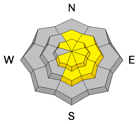
Today’s strong winds will be drifting the snow, layering it into denser slabs that will be sitting on weak snow or slick crusts. These new drifts will be cracky, and break out under the weight of a person. Once any new wind slab releases and moves down slope, it has the potential to gouge or step down into the more deeply buried weak layers, creating a much larger slide. The higher you go in elevation, the deeper and more widespread the wind drifts will be. |
 |
weather Skies will gradually clear today, though the northwesterly winds will remain mildly annoying - 15 to 25 mph averages, with gusts to 40. But if you’re heading to the high ridgelines, hold on to your hats – averages to 40 mph, with gusts in the 60s at times. 10,000’ temperatures will warm slightly into the low to mid 20s. We’re looking at a warming trend into Friday, with another micro-storm possible Friday night. |
| general announcements This information does not apply to developed ski areas or highways where avalanche control is normally done. This advisory is from the U.S.D.A. Forest Service, which is solely responsible for its content. This advisory describes general avalanche conditions and local variations always occur. If you trigger an avalanche in the backcountry - especially if you are adjacent to a ski area – please call the following teams to alert them to the slide and whether anyone is missing or not. Rescue teams can be exposed to significant hazard when responding to avalanches, and do not want to do so when unneeded. Thanks. Salt Lake and Park City – Alta Central (801-742-2033), Canyons Resort Dispatch (435-615-3322) Snowbasin Resort Dispatch (801-620-1017), Powder Mountain Dispatch (801-745-3772 x 123). Sundance Dispatch (801-231-4150) EMAIL ADVISORY Get the Salt Lake avalanche advisory emailed to you every morning. CLICK HERE FOR DETAILS DAWN PATROL Hotline updated daily by 5-530am - 888-999-4019 option 8. Twitter Updates for your mobile phone - DETAILS UDOT canyon closures: LINK TO UDOT Utah Avalanche Center mobile app - Get your advisory on your iPhone along with great navigation and rescue tools. We'll soon be lining up a new automated emailed advisory delivery system - stay tuned. Wasatch Powderbird Guides Blog/Itinerary for the Day. They'll be up and running later this winter - Lost or Found something in the backcountry? - http://nolofo.com/ Discount lift tickets are now available at Backcountry.com - Thanks to Ski Utah and the Utah Resorts. All proceeds go towards paying for Utah Avalanche Center avalanche and mountain weather advisories. To those skinning uphill at resorts: it is your responsibility to know the resort policy on uphill travel. Some allow uphill travel and have guidelines, some don't. Contact the Ski Patrol at each resort for details. IMPORTANT: Before skinning at a resort under new snow conditions, check in with Ski Patrol. Resorts can restrict or cut off access if incompatible with control and grooming operations. Benefit the Utah Avalanche Center when you shop from Backcountry.com or REI: Click this link for Backcountry.com or this link to REI, shop, and they will donate a percent of your purchase price to the UAC. Both offer free shipping (with some conditions) so this costs you nothing! Benefit the Utah Avalanche Center when you buy or sell on ebay - set the Utah Avalanche Center as a favorite non-profit in your ebay account here and click on ebay gives when you buy or sell. You can choose to have your seller fees donated to the UAC, which doesn't cost you a penny. Remember your information can save lives. If you see anything we should know about, please participate in the creation of our own community avalanche advisory by submitting snow and avalanche conditions. You can also call us at 801-524-5304 or 800-662-4140, email by clicking HERE, or include #utavy in your tweet or Instagram. Ski Utah mobile snow updates: |


_4.jpg)
