| During the month of April, Mark Miller will donate $75 to the charity of your choice (5 to chose from, including the Utah Avalanche Center!) Mark Miller Subaru has raised over $300k in the previous 6 Do Good Feel Good events. More Info here |  |
| During the month of April, Mark Miller will donate $75 to the charity of your choice (5 to chose from, including the Utah Avalanche Center!) Mark Miller Subaru has raised over $300k in the previous 6 Do Good Feel Good events. More Info here | |
| Advisory: Ogden Area Mountains | Issued by Bruce Tremper for Monday - December 30, 2013 - 7:19am |
|---|

|
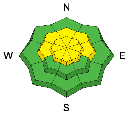
bottom line Level 2 (Moderate) avalanche danger still lingers on upper elevation, northwest, north, northeast and east facing slopes. These avalanches are difficult to trigger but they will be large and dangerous if you do. Also avoid the isolated hard wind deposits mostly along the higher ridge lines. Usually-safe slopes: Most southerly-facing slopes and other slopes less steep than 30 degrees not locally-connected to steeper terrain. Always use low-risk travel procedures when traveling in avalanche terrain, carry and practice with your avalanche gear, and continually reevaluate your plans and terrain choices.
|
 |
special announcement The Utah Avalanche Center along with the Montana State University Ski Tracks project combines GPS technology with detailed logbook surveys completed by participants to help us understand how and why decisions are made in the winter backcountry. Participants will use a free smartphone app to record and send us their ski routes then, they will complete a simple online survey telling us some of the features of their tour. For more information visit: www.montana.edu/snowscience/tracks |
 |
current conditions We've had some stiff wind overnight from the northwest blowing 52, gusting to 66, on the highest peak with about half that speed on most ridge tops. Temperatures are in the mid teens. We had a few clouds overnight. Snow surface conditions are extremely variable ranging from hard, frozen sun crust on sunny slopes, hard, wind-damaged snow along the ridges with lots of soft, faceted snow and surface hoar on the wind and sun sheltered slopes. Most of these slopes are still supportable but on some, you are sink into bottomless depth hoar to the ground. Total snow depth is 2-3 feet with occasionally deeper snow in the upper Cottonwood Canyons. |
 |
recent activity We did not hear about any recent avalanches from the backcountry yesterday, but most people avoided the more bold lines. Avalanche mitigation work with explosives at the resorts continued to produce a couple large, deep slabs, one class 3 in un-skied, high elevation, north-facing terrain and another slide to the ground at Park City. You can see all the backcountry observations on our All the Good Stuff page.
|
| type | aspect/elevation | characteristics |
|---|

|
|
LIKELIHOOD
 LIKELY
UNLIKELY
SIZE
 LARGE
SMALL
TREND
 INCREASING DANGER
SAME
DECREASING DANGER
|
|
description
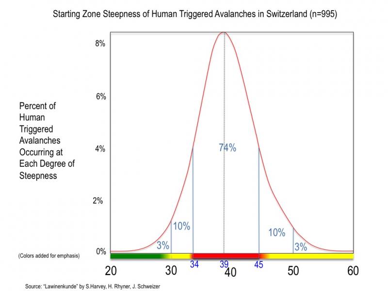
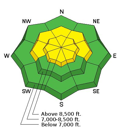
We have lowered the avalanche danger rating to Level 2 (Moderate) danger or less on all slopes in the Ogden area mountains. Avalanche danger depends on BOTH probability and consequences. The consequences remain the same; the slabs are not only large and deep but in this shallow snowpack, any avalanche will rake your through the rocks and logs on the ground. The probability, however, continues to diminish. It's been a week since we've had any significant loading and the strong temperature gradient continues to rot away the entire snowpack including the overlying slab. So the snowpack has kind of a dead feeling, like thumping an over-ripe watermelon. With both old and new wind drifts on the upper elevation terrain, there may be enough new load and energy to trigger dangerous slabs there. Most of the smart folks continue to avoid upper elevation slopes that face northwest, north, northeast and east that approach 35 degrees and steeper.
Bonus tutorial: |
| type | aspect/elevation | characteristics |
|---|

|
|
LIKELIHOOD
LIKELY
UNLIKELY
SIZE
 LARGE
SMALL
TREND
 INCREASING DANGER
SAME
DECREASING DANGER
|
|
description
Although there was not a lot of snow to blow around, the strong winds from the northwest overnight likely created some fresh wind slabs. As always avoid any steep slope with recent wind deposits, which often look smooth and rounded. These slabs will probably be quite hard. |
 |
weather We will have warming temperatures today, rising up to just below freezing. Ridge top winds will diminish and turn more westerly and southwesterly tonight. We will have variable clouds today. We have a weak disturbance for Tuesday, which will bring us mostly clouds and perhaps an occasional snowflake or two. Winds are forecasted to pick up with this disturbance as well and blow from the southwest to northwest. The extended forecast calls for a return to high pressure and--glimmer of hope--it looks like a cold blast of air might arrive in about a week but the computer models continue to be very uncertain. |
| general announcements This information does not apply to developed ski areas or highways where avalanche control is normally done. This advisory is from the U.S.D.A. Forest Service, which is solely responsible for its content. This advisory describes general avalanche conditions and local variations always occur. If you trigger an avalanche in the backcountry - especially if you are adjacent to a ski area – please call the following teams to alert them to the slide and whether anyone is missing or not. Rescue teams can be exposed to significant hazard when responding to avalanches, and do not want to do so when unneeded. Thanks. Salt Lake and Park City – Alta Central (801-742-2033), Canyons Resort Dispatch (435-615-3322) Snowbasin Resort Dispatch (801-620-1017), Powder Mountain Dispatch (801-745-3772 x 123). Sundance Dispatch (801-231-4150) DAWN PATROL Hotline updated daily by 5-530am - 888-999-4019 option 8. Twitter Updates for your mobile phone - DETAILS UDOT canyon closures: LINK TO UDOT Utah Avalanche Center mobile app - Get your advisory on your iPhone along with great navigation and rescue tools. We'll soon be lining up a new automated emailed advisory delivery system - stay tuned. Wasatch Powderbird Guides Blog/Itinerary for the Day. They'll be up and running later this winter - Lost or Found something in the backcountry? - http://nolofo.com/ Discount lift tickets are now available at Backcountry.com - Thanks to Ski Utah and the Utah Resorts. All proceeds go towards paying for Utah Avalanche Center avalanche and mountain weather advisories. To those skinning uphill at resorts: it is your responsibility to know the resort policy on uphill travel. Some allow uphill travel and have guidelines, some don't. Contact the Ski Patrol at each resort for details. IMPORTANT: Before skinning at a resort under new snow conditions, check in with Ski Patrol. Resorts can restrict or cut off access if incompatible with control and grooming operations. Benefit the Utah Avalanche Center when you shop from Backcountry.com or REI: Click this link for Backcountry.com or this link to REI, shop, and they will donate a percent of your purchase price to the UAC. Both offer free shipping (with some conditions) so this costs you nothing! Benefit the Utah Avalanche Center when you buy or sell on ebay - set the Utah Avalanche Center as a favorite non-profit in your ebay account here and click on ebay gives when you buy or sell. You can choose to have your seller fees donated to the UAC, which doesn't cost you a penny. Remember your information can save lives. If you see anything we should know about, please participate in the creation of our own community avalanche advisory by submitting snow and avalanche conditions. You can also call us at 801-524-5304 or 800-662-4140, email by clicking HERE, or include #utavy in your tweet or Instagram. |


_4.jpg)