
| During the month of April, Mark Miller will donate $75 to the charity of your choice (5 to chose from, including the Utah Avalanche Center!) Mark Miller Subaru has raised over $300k in the previous 6 Do Good Feel Good events. More Info here |  |
| During the month of April, Mark Miller will donate $75 to the charity of your choice (5 to chose from, including the Utah Avalanche Center!) Mark Miller Subaru has raised over $300k in the previous 6 Do Good Feel Good events. More Info here | |
| Advisory: Ogden Area Mountains | Issued by Evelyn Lees for Sunday - December 15, 2013 - 7:20am |
|---|

|
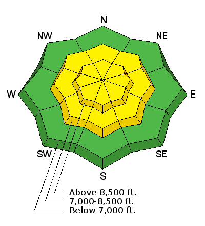
bottom line MODERATE means HUMAN-TRIGGERED AVALANCHES ARE POSSIBLE. The avalanche danger Is MODERATE on all steep mid and upper elevation slopes that have new drifts of wind-blown snow. There is also a MODERATE danger for triggering a deeper, more dangerous slide on west through north through easterly facing slopes, above about 9,000, on mid pack weaknesses. Triggered slides will be dangerous - up to 150’ wide, 2’ deep, with stepped up consequences due to the potential for a long, rocky ride. Continue to recreate on lower angle slopes, less steep than about 35 degrees, in wind sheltered terrain.
|
 |
current conditions Skies are clear in the mountains this morning, with temperatures in the Ogden mountains in the teens and low 20s. ridge lines. The northwesterly winds have increased – along the Ogden ridges, speeds are averaging 20 to 30 mph, with gusts to 40. Sunny slopes are crusted and we’re adding another insulting round of wind damage today – hard and soft breakable wind drifts. Riming was also reported from the Ogden area mountains yesterday. Once again, the best bet for soft snow will probably be on shady, mid elevation wind sheltered slopes. |
 |
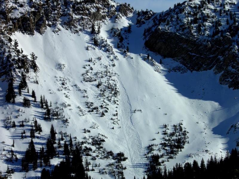
recent activity No new avalanches reported from the Ogden area mountains yesterday. In the Salt Lake mountains, there was one human triggered slide reported yesterday – a soft slab about 15” deep, widening to 60 feet, in Holy Toledo, a northwest facing slope in upper Cardiff Fork at 10,200. One person was carried, and stopped on top mid track, with no injuries. Collapsing was reported from the Gobbler's/Mill Creek area, west facing aspects on the Park City side, and in White Pine in Little Cottonwood Canyon.
|
| type | aspect/elevation | characteristics |
|---|

|
|
LIKELIHOOD
 LIKELY
UNLIKELY
SIZE
 LARGE
SMALL
TREND
 INCREASING DANGER
SAME
DECREASING DANGER
|
|
description
The snowpack continues to be teetering on the edge with this avalanche problem - very poor snowpack structure and collapsing are indications of the mid-pack faceted weak layer that can barely handle the load above. Today, especially avoid any of the west through north through easterly facing slopes with new drifts of wind-blown snow. The extra weight of the new wind drifts may be just enough to tip the balance toward instability once again. The chances of triggering a slide aren’t high, but the consequences if you do are. The slides that could be triggered on the faceted mid pack weak layers are Class 2’s –one to two feet deep, long running, large enough to carry a person and entraining enough snow to bury a person. |
| type | aspect/elevation | characteristics |
|---|

|
|
LIKELIHOOD
 LIKELY
UNLIKELY
SIZE
LARGE
SMALL
TREND
 INCREASING DANGER
SAME
DECREASING DANGER
|
|
description
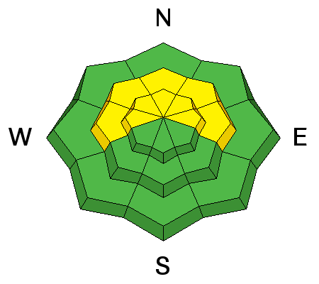
The latest headline is the new wind slabs being formed by the
|
 |
weather Clear skies and lots of sun in the mountains today, with temperatures in the low 30s at the low to mid elevations, and warming into the mid 20’s at the upper elevations. The northwesterly winds will remain annoying throughout the day -20 to 30 mph averages, with speeds across the highest ridges downright offensive at times - 40 mph averages, with stronger gusts. Winds speeds will gradually decrease this afternoon into tonight. The high pressure strangle hold on northern Utah will continue; the hoped for Thursday storm is looking weaker all the time. |
| general announcements This information does not apply to developed ski areas or highways where avalanche control is normally done. This advisory is from the U.S.D.A. Forest Service, which is solely responsible for its content. This advisory describes general avalanche conditions and local variations always occur. If you trigger an avalanche in the backcountry - especially if you are adjacent to a ski area – please call the following teams to alert them to the slide and whether anyone is missing or not. Rescue teams can be exposed to significant hazard when responding to avalanches, and do not want to do so when unneeded. Thanks. Salt Lake and Park City – Alta Central (801-742-2033), Canyons Resort Dispatch (435-615-3322) Snowbasin Resort Dispatch (801-620-1017), Powder Mountain Dispatch (801-745-3772 x 123). Sundance Dispatch (801-231-4150) Twitter Updates for your mobile phone - DETAILS UDOT canyon closures: LINK TO UDOT Utah Avalanche Center mobile app - Get your advisory on your iPhone along with great navigation and rescue tools. We'll soon be lining up a new automated emailed advisory delivery system - stay tuned. Wasatch Powderbird Guides Blog/Itinerary for the Day. They'll be up and running later this winter - Discount lift tickets are now available at Backcountry.com - Thanks to Ski Utah and the Utah Resorts. All proceeds go towards paying for Utah Avalanche Center avalanche and mountain weather advisories. To those skinning uphill at resorts: it is your responsibility to know the resort policy on uphill travel. Some allow uphill travel and have guidelines, some don't. Contact the Ski Patrol at each resort for details. IMPORTANT: Before skinning at a resort under new snow conditions, check in with Ski Patrol. Resorts can restrict or cut off access if incompatible with control and grooming operations. Benefit the Utah Avalanche Center when you shop from Backcountry.com or REI: Click this link for Backcountry.com or this link to REI, shop, and they will donate a percent of your purchase price to the UAC. Both offer free shipping (with some conditions) so this costs you nothing! Benefit the Utah Avalanche Center when you buy or sell on ebay - set the Utah Avalanche Center as a favorite non-profit in your ebay account here and click on ebay gives when you buy or sell. You can choose to have your seller fees donated to the UAC, which doesn't cost you a penny. Remember your information can save lives. If you see anything we should know about, please participate in the creation of our own community avalanche advisory by submitting snow and avalanche conditions. You can also call us at 801-524-5304 or 800-662-4140, email by clicking HERE, or include #utavy in your tweet or Instagram. |


_4.jpg)
 northwesterly winds. The wind-blown snow is landing on a variety of old snow surfaces - slick crusts, loose faceted snow, or a combination of facets on a hard bed surface. These drifts will be cracky and you may be able to trigger them from a distance. They will be most widespread along ridgelines, on easterly facing slopes, but also cross loaded along gully walls, around sub ridges, and on break overs on both mid and upper elevation slopes. Image of Cross Loading, from our