| During the month of April, Mark Miller will donate $75 to the charity of your choice (5 to chose from, including the Utah Avalanche Center!) Mark Miller Subaru has raised over $300k in the previous 6 Do Good Feel Good events. More Info here |  |
| During the month of April, Mark Miller will donate $75 to the charity of your choice (5 to chose from, including the Utah Avalanche Center!) Mark Miller Subaru has raised over $300k in the previous 6 Do Good Feel Good events. More Info here | |
| Advisory: Ogden Area Mountains | Issued by Bruce Tremper for Friday - December 13, 2013 - 6:55am |
|---|

|
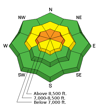
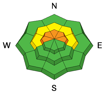
bottom line The overall avalanche danger is Level 2 (MODERATE) however there is still a Level 3 (CONSIDERABLE) avalanche danger on slopes steeper than 35 degrees that face the north half of the compass plus east facing slopes. Low probability - high consequence avalanche conditions still persist on these slopes and will likely persist through the weekend.
|
 |
special announcement For an excellent, first person account of the Grizzly Gulch avalanche incident last Monday, December 9th, check out her blog post. |
 |
current conditions Clouds are just starting to reach northern Utah this morning with light snow showers expected today. Ridge top winds have picked up a bit and are blowing 20, gusting to 30 along the highest peaks. Temperatures are in the mid teens and got up to nearly 40 degrees yesterday. Snow surface conditions remain a mixed bag with soft, settled, recrystallized snow on the northerly-facing slopes, wind damage in upper elevation, wind exposed terrain and refrozen sun crusts and lots of rocks on most of the southerly-facing slopes. |
 |
recent activity We did not hear about any significant avalanche activity from the backcountry yesterday with relatively minor activity from the resorts.
|
| type | aspect/elevation | characteristics |
|---|

|
|
LIKELIHOOD
 LIKELY
UNLIKELY
SIZE
 LARGE
SMALL
TREND
 INCREASING DANGER
SAME
DECREASING DANGER
|
|
description
This past week we have seen how persistent weak layers got their name. Like Clair Isrealson from Canada puts it, "Dealing with depth hoar is like when your crazy aunt comes for a visit; she just stays forever and you just never know when she's going to snap." After the flurry of activity on Sunday and Monday, things have SLOWLY become more dormant. Yet many people have reported widespread, sensitive, collapsing snow in the many areas. Check out Cam McKenzie's excellent observation from White Pine yesterday and especially check out his videos of larger Extended Column Tests. Yah, that's what I'm talkin' about. Plus, the intrepid Mark White experienced lots of collapsing yesterday in Cardiff Fork. It's a Dirty Harry situation with low probability and high consequences. How lucky do you feel? Interestingly enough, yesterday, I visited Mill Creek where I found more snow cover than in the Cottonwood Canyons and a more stable snowpack. I have no idea why. Our first-string observer, Greg Gagne found the same thing. Although most of the snowpack is Level 2 (Moderate) avalanche danger, I'm still calling it a Level 3 (Considerable) danger on slopes that face the north half of the compass above about 8,500', especially in places that did not see a lot of tracks during November when the weak layer was formed. |
| type | aspect/elevation | characteristics |
|---|

|
|
LIKELIHOOD
LIKELY
UNLIKELY
SIZE
 LARGE
SMALL
TREND
 INCREASING DANGER
SAME
DECREASING DANGER
|
|
description
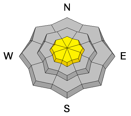
With increasing wind today we may see a few sensitive wind slabs in the upper elevation, wind exposed terrain. As always, avoid any steep slope with recent wind deposits, which often look smooth and rounded. |
 |
weather Today you can experience the rare phenomenon of snow simultaneously produced from two different kinds of weather. First, small snow grains are falling out of the thick layer of smog stuck in the valleys and second, some higher clouds will produce very light snow showers in the mountains. Hey, weather geeks have to keep themselves entertained somehow. This weak system passing by will increase the winds in the mountains and they will blow from the west 30, gusting to 40 along the high peaks and half that on most ridges. Today, the temperature should rise from the mid teens to the mid 20's. The extended forecast is depressing with continued smog in the valleys and warm, sunny weather in the mountains until about a week from today when a cold front will blow out the smog and bring some snow to the mountains. |
| general announcements
This information does not apply to developed ski areas or highways where avalanche control is normally done. This advisory is from the U.S.D.A. Forest Service, which is solely responsible for its content. This advisory describes general avalanche conditions and local variations always occur. If you trigger an avalanche in the backcountry - especially if you are adjacent to a ski area – please call the following teams to alert them to the slide and whether anyone is missing or not. Rescue teams can be exposed to significant hazard when responding to avalanches, and do not want to do so when unneeded. Thanks. Salt Lake and Park City – Alta Central (801-742-2033), Canyons Resort Dispatch (435-615-3322) Snowbasin Resort Dispatch (801-620-1017), Powder Mountain Dispatch (801-745-3772 x 123). Sundance Dispatch (801-231-4150) Twitter Updates for your mobile phone - DETAILS UDOT canyon closures: LINK TO UDOT Utah Avalanche Center mobile app - Get your advisory on your iPhone along with great navigation and rescue tools. We'll soon be lining up a new automated emailed advisory delivery system - stay tuned. Wasatch Powderbird Guides Blog/Itinerary for the Day. They'll be up and running later this winter - Discount lift tickets are now available at Backcountry.com - Thanks to Ski Utah and the Utah Resorts. All proceeds go towards paying for Utah Avalanche Center avalanche and mountain weather advisories. To those skinning uphill at resorts: it is your responsibility to know the resort policy on uphill travel. Some allow uphill travel and have guidelines, some don't. Contact the Ski Patrol at each resort for details. IMPORTANT: Before skinning at a resort under new snow conditions, check in with Ski Patrol. Resorts can restrict or cut off access if incompatible with control and grooming operations. Benefit the Utah Avalanche Center when you shop from Backcountry.com or REI: Click this link for Backcountry.com or this link to REI, shop, and they will donate a percent of your purchase price to the UAC. Both offer free shipping (with some conditions) so this costs you nothing! Benefit the Utah Avalanche Center when you buy or sell on ebay - set the Utah Avalanche Center as a favorite non-profit in your ebay account here and click on ebay gives when you buy or sell. You can choose to have your seller fees donated to the UAC, which doesn't cost you a penny. Remember your information can save lives. If you see anything we should know about, please participate in the creation of our own community avalanche advisory by submitting snow and avalanche conditions. You can also call us at 801-524-5304 or 800-662-4140, email by clicking HERE, or include #utavy in your tweet or Instagram. |


_4.jpg)